
-
 4295 Hits
-
 81.18% Score
-
 13 Votes
|
|
Mountain/Rock |
|---|---|
|
|
46.71229°N / 11.12266°E |
|
|
Hiking |
|
|
Spring, Summer, Fall |
|
|
7516 ft / 2291 m |
|
|
Overview

Mutspitz, rising above Merano
Lower on the slopes of Mutspitz there are of course also many other combinations for hiking. They can end at the uper station of the cable car, or you can descend all the way down to Tirol village. What we tried, but were not allowed (crowd in cable car), was to take to the upper station mountain bikes.
And the final overview note - not far away from Mutspitz there is the beautiful area of Spronser lakes. They lie in the upper part of the long Spronser Tal (valley), bordering Mutspitz on the northeast. In summer, when days are longer, you can continue from Mutspitz to Taufenscharte, then further on to the lakes and then either return on the southern side over the Hochgangschartl, 2441 m, or descend by Spronser valley and then cross the slopes of Mutspitz, also reaching the upper station of cable car. But the area of Spronser lakes already belongs to the summit of Spronser Roetelspitz / Cima Rossa, 2625 m.
Summit Panorama
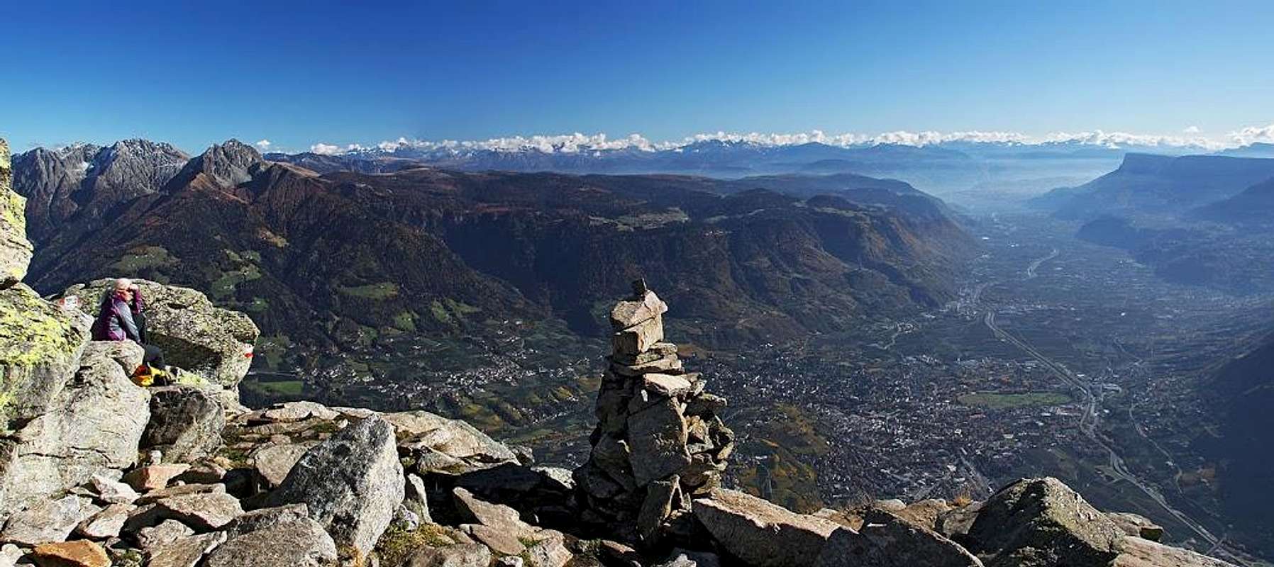
Southern panorama

Tschigot and Lodner

Western views
Tirol Castle

Tirol castle
Getting There
Hochmut farm
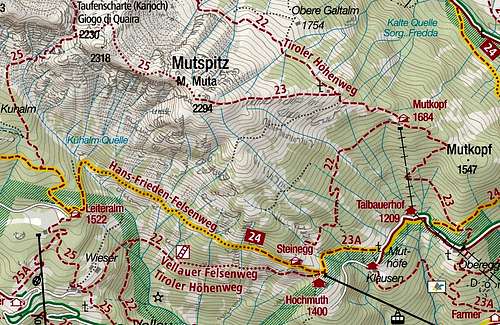
1. As said, the most popular and convenient is the cable car to the famous farm of Hochmut (also: Hochmuth), 1351 m. The lower station, 680 m, is in the village Tirol (Dorf Tirol / Tirolo), just north of Merano. You can drive there by car, or use the city transport. See on the web till when in the season the cable car is operating (usually till the end of October). It is said that when there is no crowd, they take on cable car also mountain bikes. That would allow you to buy only one way ticket and on return enjoy a fine bike descent.
2. The second option would be to use the chair lift and then cable car from Algund/Lagundo to Leiteralm, 1522 m. It operates in summer time.
3. Finally, one could start the tour also in the valley of Spronser Tal. But that's quite low, 1070 m.
Routes Overview


Eastern views
1. From Hochmut
The trailhead is at the famous farm (and restaurant), near the upper station of cable car, 1351 m. From there we take a comfortable path uphills (towards the NW). In a few switchbacks it brings us to the Steinegg restaurant, 1439 m, where we turn right, leaving the Meraner high path and following the path No. 22. It crosses the slopes towards the NE, going mostly through dense woods and ascending only gently. It's all the time very easy and comfortable (difficulty T2/T1). After 1 hour from cable car we reach the hut of Mutkopf, 1684 m, standing on the long SE ridge of Mutspitz.

On the SE ridge

On the SE ridge
2. Taufenscharte Round Tour
Continuing of the main ridge is more demanding, the path is marked as of "black difficulty", so one degree harder than the ascent route. It first follows the ridge, then avoids the last summit by the right and descends into the notch, 2230 m. There you turn left and descend by the path No. 25 to Leiteralm, from where you go by the Hans-Frieden-Felsenweg to the upper cable car station. Also this path has a few protected places. For the whole round tour you can count 5 hours of walk.
3. From Spronser Tal
From the lower station of material cable way the Meraner Hohenweg (No. 24) goes southwards and then around the Mutkopf up to the Mutkopf house. Then you continue on top by the SE ridge.
Red Tape
No limitations.When To Ascend?
| Mutspitz is mostly ascended during the dry seasons. Follow the cable car schedule. In winter, when the cable car is not operating, the ascents are very long and high and also the summit part of the ascent ridge can become dangerous. | Click for weather forecast |
Mountain Huts

Once more Hochmut
Steinegg, 1439 m. Only a restaurant. 10 min from the cable car.
Mutkopf, 1684 m. Only a restaurant. 1 h from the cable car.
Leiteralm, 1522 m. Reachable by cable car.
Bockerhuette, 1628 m. North of Mutspitz, reachable by the Spronser Tal path.