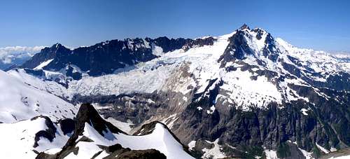
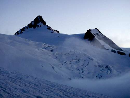
Shuksan is an amazingly complex peak. The summit block towers over 9 separately named glaciers (6 if you don't count upper, lower, east, west divisions) and is commonly referred to as "the pyramid". Shuksan is the fifth highest non-volcanic mountain in Washington State. I have heard claims that it is also the most photographed mountain in the world, even more than the Matterhorn or Cerro Torre. At first I didn't believe it, but then after seeing it in countless hotel rooms in Europe and North America, painted on the side of a building in east Africa, and posted above an ice-cream parlor in southwest Bolivia, I started to believe.
The North Face, 2007
My Shadow And Alpenglow On The Mountain, 2010
For years I have felt certain that my mountaineering obsession would one day draw me to this mountain, but for some reason I didn't feel the acute urgency that I sometimes contract with other mountains. Then this July, I climbed Olympus and Bonanza within a 6 day stretch, both of which involve massive elevation gain, glacier crossings, and rock climbing. After those climbs, I felt a new confidence in my own abilities. Shuksan came to the forefront of my mind. Although most parties take 2 to 3 days on the Sulfide Glacier route, I wanted to make a one-day ascent. This would require a very strong team. For a few weeks I discussed the idea with my friends Matt and Colleen. We were all agreed and keen to give it our best shot. We waited for an ideal weather window.
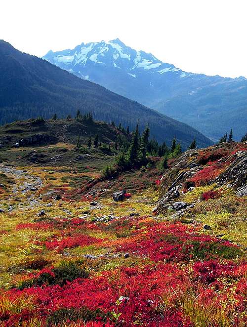
Shuksan In Fall, 2006
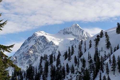
Shuksan In Winter, 2007
Friday July 22, 2011
Sunny skies predicted in the forecast. After work, we drove to the trailhead at 2400 feet, and set our alarms for 1:00 am. I put my sleeping bag on the ground next to the car and slept for a couple of hours.
Saturday July 23, 2011
When I got up, I scarffed down a quick breakfast. By 1:35 am, we were moving along the trail with our headlamps, crossing streams in the dark. Eventually we rose above the snow line and the trail disappeared. It was harder to follow the route through the snow in dense forest. Organic debris from the trees made boot tracks harder to follow in the dark. (I later found out that a search and rescue operation was launched the same day to find a lost climber on this section of the trail). With paper maps and two GPS devices we were able to find our way to the top of Shannon Ridge. We stumbled upon a campsite where a disgruntled man, half hanging out of his tent, told us "you want to go that way" before turning over and going back to sleep.
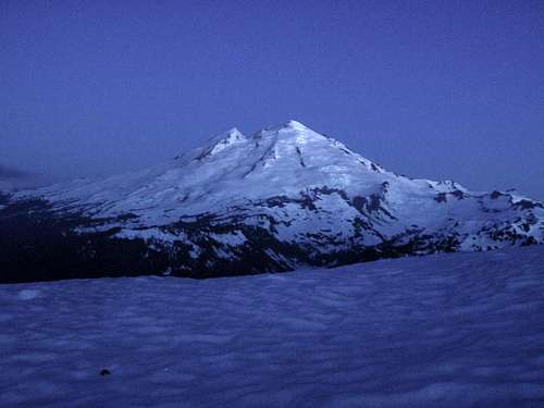
Mount Baker Before Dawn
Mount Baker After Dawn
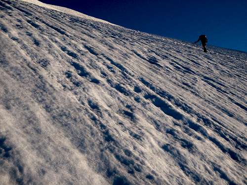
On the ridge crest the trees thinned out and soon we were on open snow. Shannon Ridge was looming large in front of us, but there wasn't enough light to make out any details. We followed old boot tracks up to a pass and crossed through cliff bands to the east side of the ridge, passing more tents as we went. When we reached 5500 feet I noticed the sky to the east was growing brighter. It would just be another hour or so until sunrise. We could see a pink halo tracing the horizon as solar rays illuminated the atmosphere. To the west I could see Mount Baker. I used my ice axe as a tripod in the snow to take some long exposures. Then the first rays of light hit the volcano and it turned pink. I was the first one to notice it and I made a bunch of obnoxious excited noises. Matt and Colleen climbed up to my vantage point to see what all the fuss was about.
Nearing The Glacier
Scenic Camp Spot
We continued to climb on snow, as near to the ridge crest as the cliffs and rock formations allowed. We were now on the edge of the massive Sulfide Glacier. To cross the glacier safely and head straight for the summit pyramid would necessitate roping up. But that was not our plan. I have several friends who had assured me that if you contour the far left edge of the glacier, there is no danger of a crevasse fall. These friends of mine have literally thousands of ascents worth of experience and one of them has climbed Shuksan 5 times, so I trusted their advice. Our route was not as direct as the standard Sulfide crossing, but it would be faster without taking the time to rope up.
The Summit Pyramid And Crevasses
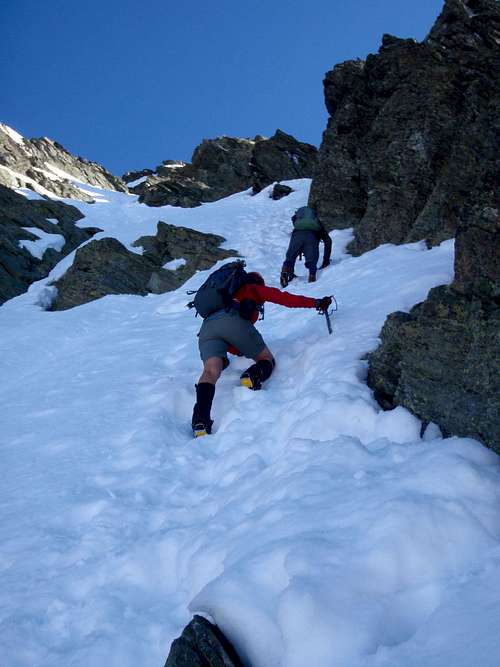
Climbing Steep Snow
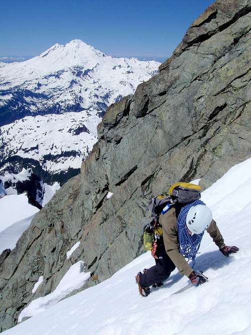
Just before the sun hit the snow, we passed an amazing camp site. Two tents stood erected in the center of four rock pinnacles which jutted out of the ridge at different angles, resembling the petals of an opening flower. As a backdrop, the predawn horizon was still shining pink. I swore to myself that if I ever climbed Shuksan a second time, I would bring my tent and pitch it right there. We climbed up through a thin layer of clouds and then the sunlight touched down around us turning the snow yellow and the shaded areas blue. We could see the pyramid now, standing tall above the glacier. It looked impossibly steep, but I reminded myself that this was an optical illusion, caused by looking directly at a steep slope. We could see that most of the standard scramble route up the central gully on the south face was still filled in with snow. Unusually cold and wet weather in Washington this year has made many of our climbing routes at least one month behind schedule for normal melted-out conditions.
The Objective
The Pyramid
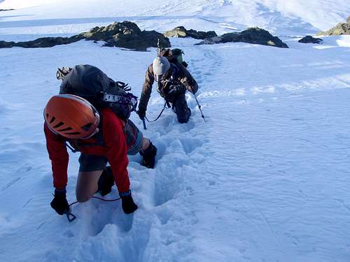
We reached the base of the pyramid and were careful to traverse over to the right side so we could get around the bergschrund that was partly open. Having passed so many tents, we couldn't help but wonder where everyone else was. For as far as we could see, there was no one on the glacier coming up behind us. What happened to good old-fashioned alpine starts? We climbed up the base of the central gully following the steps that were already kicked in. The slope now exceeded 60 degrees. The whole south face of the pyramid was still in shadow and the snow was as hard as ice. It was frozen so hard that we couldn't even jam our ice axes through the crust layer. There was no choice but to seek out the holes where others had previously placed their axes. But in some places, no such holes were available. In those spots we swung our axes like ice-tools, jamming the picks in as deep as we could for security.
Climbing The Base Of The Pyramid
On The Rock Rib
The slope grew steeper again and the steps ended at a rock rib. We scrambled up the rib and our crampons screeched and skidded on the rocks. On the other side of the rib the steps continued on icy snow. We were now about half way up the pyramid. I could feel that the air was thinner here. I usually notice altitude somewhere between 8000 and 9000 feet as a shortness of breath and a slight dizziness that comes with exertion. The slope was growing steeper, approaching 70 degrees. We had to climb through one bottle-neck where the snow was only a foot wide, with rock ribs on either side. The snow was thin and we had to exercise extreme caution.
Above The Rock Rib
Above I could see the remainder of the central gully up to the left. There were no steps going that way. Instead they turned to the right and ended on the southeast ridge of the pyramid. We were still in shade and the snow was like concrete. To climb the gully we would have to rely only on the front points of our crampons. Without proper ice-tools it was not a safe option. But the southeast ridge? That route was said to be anywhere from YDS 5.4 to 5.6 and extremely exposed. It was recommended to bring your rock shoes if attempting that route and nobody in our group had anticipated we would need them.
Exposure In The Bottleneck
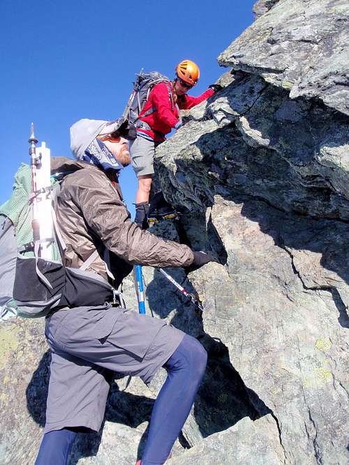
We climbed up off of the snow and scrambled a short way before coming to a near vertical wall, 35 feet high. Matt scouted ahead along a small ledge which looked like it might go around the wall on the east face of the pyramid. The drop behind him was 1000 feet down to the Crystal Glacier. He came back and told us it was no good. I could tell from the tone in his voice that I didn't want to investigate it myself. I put my pack down so that I could climb up the base of the wall and see if there was any way to protect it. I was hoping to find a horn or a crack or just anything. The rock was all down-sloping without any major features. You would have to be pretty creative to set an anchor on this wall. 10 feet up the wall I could see what lay ahead and I didn't like it. A slip there would be fatal. I down-climbed back to the group. Colleen and Matt had to tell me where to put my feet as I couldn't see anything below an overhang.
At The Base Of The Wall
We talked about what we should do. Colleen's GPS was reading 9000 feet, just 130 shy of the summit. It seemed we had 3 options. The first option was for one of us climb this wall unprotected and see if there was anything above it that would serve as a belay station. I asked if either of them felt bold enough to do that since they both have a lot more rock climbing experience than me. After all, this was only my third time on rock. Neither of them liked the looks of it. Matt was worried about what he might find above the wall. What if he got up there and there was no place to set up a belay or rappel? It was a valid point. Option number two was that we rappel back down to the gully and try to follow the steep exposed snow up to the summit or over to the southwest ridge which didn't look any better. But that wouldn't be safe until the snow had been in the sun long enough to soften up, a matter of several hours. Our last choice would be to turn around. I certainly didn't want to do that. There wasn't a cloud in the sky and it was still early morning. "The hell with it", I thought, we can sit here and wait if that's what we have to do.
Climbing The Wall
But then we heard voices below us. There was another party coming up. We waited to see what they would do. I felt a little embarrassed to be sitting around at 9000 feet, unsure of our next step. The two young men appeared and climbed right past us, unprotected all the way up the wall. We asked them if they could see any anchor points near the top and they said yes. Excellent! We wouldn't have to wait for the snow after all. Matt climbed up unprotected following the same line as the other guys. Next, Colleen climbed up with a belay, and I went last. We all left our packs and crampons at the base of the wall. I scrambled a little higher and was surprised to see that the summit was not an exact point as it appears from afar but an elongated ridge with a couple of high points. We went to the highest one which was still shrouded in snow. I could now see many parties down on the Sulfide Glacier approaching the pyramid. I smiled to myself. It's about time those lazy bums got moving.
Climbing Up To The Summit
I looked at Mount Baker and remembered how small Shuksan had seemed from that summit, even though Baker is only 1300 feet higher. Right below us on the north face was the incredible Hanging Glacier, riddled with enormous crevasses. I stared at Mount Larrabee to the north and recalled fond memories of that climb with my friend Beau. And there was Tomyhoi! Where I met Greg Slayden for the first time when he invited me to join the expedition to South America. To the south were the giant volcanoes, Glacier Peak and Mount Rainier, also memorable climbs. We spent some time trying to guess which ones were Hozomeen and Jack Mountain. Then I spotted Mox Peaks. That sent a chill up my spine. Many climbers say the Mox grouping is the most dangerous on the Washington Top 100 . Point 8501, also known as "Hardest Mox" saw its first ascent just three years ago.
Colleen Makes The First Rappel
The Third Rappel
It was time to go down. We wanted to get off the ridge before it was choked with multiple parties. We rappelled down the wall and collected our gear. Two more rappels on snow brought us part way down the gully. Several other parties passed us on the way up. We down-climbed the lower half of the pyramid, facing in. The snow had softened up a little but was not good enough for plunge-stepping. At the base of the pyramid we retraced our steps around the bergschrund and over to the far edge of the glacier. It was early afternoon and the blinding light from the snow was making us hot. The reflection burned the underside of my nose and inside my mouth. Matt ran out of water and then Colleen did as well. Mine was last to go. I filled my hat with snow several times and let the water drip down over my head and body, soaking my clothes. I've learned that this can lower body temperature and slow sweat production when drinking water is scarce.
Down-Climbing
There were a number of nice glissade slopes on the way back to Shannon Ridge. I made full use of that. I remembered to retrieve my trail runner shoes at the pass but unfortunately I blew right past my water filter which I had stashed next to the last stream in the woods. Matt and Colleen had to wait for me as I climbed back up to find it. Back in the parking lot, we ate food for an hour and then laid back down on the ground for a second night on the dirt. After 15 miles and nearly 16 hours of climbing, we were so tired. We didn't feel like driving anywhere. From the very beginning, I suspected this would be the case. But who cares! We climbed Shuksan in a day. And honestly, I'm more content sleeping outside in the forest than I am in my own bed.
I tried to climb this early in my career, and the summit pyramid intimidated the hell out of me and my partner. We got halfway up and scooted away, tail between legs! Nice pictures of the final climb.
Yeah, it was 1999, I'd been "climbing" (aka pretending) for about a year. Well if I get back there for a visit some summer (who knows when) I've definitely got some things I want to do. I think Shuksan by the Fisher Chimneys, which is the favorite route of a friend of mine, I've got to take him up on the recommendation.
Congratulations - looks a fantastic route on a great mountain. You sure get around - I enjoyed your TR which included Aconcagua & Ojos seemingly just a short while ago!
What next - an 8000er?
Thank you! It's been a great year for me so far. I'm really happy to get so many kudos through this site. What's next? Well, a lot of peaks here in the Cascades to start but I'd really like to Ckeck out Mera in Nepal and Damavand in Iran. I'm not sure I want to venture much higher than I already have though. Life around 23,000 feet is not much fun.
Thanks. I hope others can be inspired to climb Shuksan. It's one of the few heavily glaciated peaks around here that has a safe route where it's not necessary to rope-up.
Yes, we're both raising the bar in terms of the peaks we're climbing. It's excting that we can learn to be better climbers by going on trips together. See you at the trail head tonight.
Parents refers to a larger category under which an object falls. For example, theAconcagua mountain page has the 'Aconcagua Group' and the 'Seven Summits' asparents and is a parent itself to many routes, photos, and Trip Reports.


Comments
Post a Comment