
-
 5669 Hits
-
 83.5% Score
-
 17 Votes
|
|
Mountain/Rock |
|---|---|
|
|
49.12145°N / 7.77085°E |
|
|
Sport Climbing |
|
|
1115 ft / 340 m |
|
|
Overview
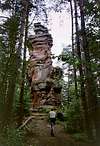
 Napoleon North Face Napoleon North Face |
Napoleon (also Napoleonsfels, sometimes Spitzfels) - a famous name for one of the most beautiful towers of the Südpfalz climbing area. This page's object is a standalone crag, truly standalone since there is no crag around, which is located on top of the Retschelstein mountain to the west of the village of Bruchweiler-Bärenbach. Hidden amongst trees the crag is nearly invisible until you are within about 100m of it. There is a popular hiking route going nearby,in fact there is a hiking trail intersection to the west of Napoleon, from where a narrow path leads straight to the rock, looming among the trees. Experience this path during sunset and you won't be able to forget Napoleon anymore.
The tower leans slightly to the north, its surface is nicely structured, offering multiple hand and footholds. Not many routes have been established on Napoleon, probably due to the fact that is quite hidden among the forest. To the west of the crag a tall mushroom-like structure serves as the base for most of the climbs, which either follow the west ridge or turn onto ledges through the north and south faces.
What's in a name? It is hard to find information about the name of the crag. Two versions exist, trying to explain it: either a) a detachment of the French revolutionary army camped their, honouring their general by naming the tower or b) the tower resembles the late French Emperor in profile. As for b), I'm not able to see the resemblance but maybe you're more lucky when looking at the pictures of this page.
|


Climbing Routes on Napoleon
 West face mushroom: Base for most climbs
Napoleon, though being a very popular destination among hikers has not overly many routes. The longish access routes might be to blame but more probably the abundance of crags nearby, where you can park your car directly underneath the cliff.
The following "table" has a link to the tour database of the PK, where you can find the grades for the free routes plus additional information. Here is the link to the complete route database.
| Feature | Routes link | Summary |
| Napoleon | Napoleon | 7 routes with variations ranging from 2 - 7+ |
Getting There
 Napoleon north-east
The shortest access to Napoleon is from Bruchweiler-Bärenbach. There is a small road which runs westward from the village to the farm buildings of Reiningshof as well as to the Pfälzerwaldhütte. Where the road forks for these two destinations a hiking trail starts right in between the two roads, which heads upwards to Napoleon. There also is a route from Dahn, but it is lengthy, taking about 45min.
To reach Bruchweiler-Bärenbach, follow one of the following itineraries (from the closest airports).
From Frankfurt
There are two possible routes which both take equally long- Via Ludwigshafen
- From Frankfurt take motorway A5 southward to Darmstadt.
- There change to A67 south.
- At Viernheimer Dreieck turn onto A6 west. Leav
- e it at Frankenthaler Kreuz for A61 south.
- At Mutterstädter Kreuz take A65 south until you reach Landau.
- At Landau turn on B10 west.
- At Hinterweidental turn onto B427 south which will take you through Dahn to Bruchweiler-Bärenbach
- Via Kaiserslautern
- From Frankfurt take motorway A3 west
- At Mönchhofdreieck turn onto A67 south
- At Rüsselsheimer Dreieck take A60 west
- At Kreuz Mainz Süd take A63 south
- At Kreuz Kaiserslautern turn onto A6 west
- At Kreuz Landstuhl turn onto A62 south
- At Pirmasens turn onto B10 east
- At Hinterweidental take B427 south to Bruchweiler Bärenbach
From Stuttgart
- Take motorway A8 to Karlsruhe
- At Karlsruher Dreieck turn north onto A5
- Tke the next exit to head for A65
- At Kandel you can leave onto B427 which will lead you directly to the north of Bruchweiler Bärenbach. At the intersection with L489 turn south to get to the village.
Red Tape
 Polygonia c-album, Comma Butterfly
The sandstone of Südpfalz forms lots of caves and overhangs. Though this makes it most interesting for climbers, two species of birds of prey compete for this habitat: the peregrine falcons and the eagle owls. Both are endangered and wherever there is a eagle owl pair found nesting in the sandstone the crag will immediately be closed. Generally this closure lasts from the beginning of each year through Aug. 1st. If breeding is not successful the closures will be canceled even before that date. For a list of closures see the Closure List of PK.
The use of magnesia is not allowed in the whole Südpfalz region. This is rather a directive or an arrangement than an outright law. Thus you probably will get away with using it but do so only when absolutely necessary. Magnesia closes the pores which you find in the sandstone and together they form a smooth surface which will get very slippery in wet conditions. The rule of thumb is to use magnesia in the highest difficulty sections and only extremely sparingly.
A list of guidelines can be found here (in German).
Accommodation
In the two villages of Bruchweiler and Bärenbach you can find pensions, apartments and restaurants. Have a look at the official site for more info. There is a campground in the village, and the one at Neudahner Weiher, north of Dahn is not far.Weather Conditions
The following link is for the town of Dahn:Maps & Books
Maps
As for maps there is a good overview map (1:50000) by Kompass Verlag but the best ones are the official topographic maps by the state government of Rheinland Pfalz, scaled 1:50000, 1:25000 and 1:5000. All official maps can be found on the web page of Landesvermessungsamt Rheinland Pfalz
1:50000
- Naturpark Pfälzer Wald
Kompass Map WK766
ISBN: 3-85491-523-3
- Pirmasens Süd
LVA RLP Map L6910
ISBN: 3-89637-193-2
1:25000
Books
Here are a number of climbing guidebooks on the region of Südpfalz. The best one is the one by U. Daigger and H.-J. Cron, complete with many topos. However, it is hard to get by and often out of print almost immediately after a new edition has been published. Currently it is available here.
- Hiking
- Pfälzerwald
B. & J.-Th. Titz
Rother Verlag
ISBN: 3-7633-4268-0 - Klettern im Buntsandstein
U. Daigger, H.-J. Cron
Westpfälzische Verlagsdruckerei St. Ingbert
ISBN: 3-00-015457-4
- Pfalz ++, Klettern im Buntsandstein
R. Burkard, P. Weinrich
Published privately
- Klettern im Naturpark Pfälzerwald
Naturfreunde Lambrecht
Published privately - Pfalz & Nordvogesen en bloc
A. Wenner, Y. Corby, I. Bald
Panico Verlag
ISBN: 3-936740-19-4
Climbing