
-
 4971 Hits
-
 77.47% Score
-
 8 Votes
|
|
Route |
|---|---|
|
|
50.70036°N / 115.30272°W |
|
|
Mountaineering |
|
|
Spring |
|
|
One to two days |
|
|
5.3 (YDS) |
|
|
III |
|
|
III |
|
|
Overview
Mount Maude is a reclusive summit, high along the continental divide, nestled against the Haig Glacier, in the high country of Kananaskis. Named in 1918 for Major General Sir Frederick Stanley Maude, a British commander who captured Baghdad during WW I. Considering the position of this mountain, it has a relatively low elevation of 3042m (9981ft.).The high altitude glacial plateau, the Haig Glacier (average elevation of 2700m, 8860 ft.), flanks the northern and eastern aspects of Mt. Maude, which is dramatically different from the southern and west slopes. The gentle southern slopes of Mt. Maude fall down to North Kananaskis Pass, Maude Lake (2350m, 7700 ft.) and Maude Brook. The western aspect drops considerably to Leroy Creek.
A vague trip report on a Calgary, Alberta based webpage for backcountry skiing was the inspiration for this ascent, unfortunately an upgrade to Biglines.com in late 2014 removed this article. Old link, " www.biglines.com/articles/maude-peak-peak-week "
A Beautiful swooping snow/ice line directly from the glacier to a deep notch in the North Ridge of Mt. Maude. This route is best done in spring or early summer when the ramp is covered in snow, and with cold temperatures, since the base of the ramp has a large bergschrund, and the surrounding ridgelines and faces are composed of loose, crappy choss looking for any chance to fall. First known complete ascent of face and ridge to the summit by Kevin Barton and Jason Wilcox in June 2009.
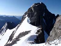
 Route Shown on NE Face/North Ridge of Mount Maude
Approach
Very likely anyone visiting Mt. Maude will approach from Alberta and Peter Lougheed Provincial Park. Access to North Kananaskis Pass, or the southern terminus of the Haig Glacier, would be from the busy summer trail along the north shore of Upper Kananaskis Lake, then heading north along the Upper Kananaskis River towards Turbine Canyon Campground, Maude Lake or North Kananaskis Pass. Maude Lake is approximately 17 kilometres from the trailhead at the North Interlakes Parking Lot. Overnight camping is available at Turbine Canyon Campground (15 km from trailhead) which requires a backcountry camping permit with prepayment and a reservation. This backcountry campground is very busy in the prime summer months.Access to the northern aspect of Mt. Maude requires extensive glacier travel and considerable approach time on these glaciers and should only be attempted by experienced mountaineers. Trailhead parking is located along the Smith-Dorrien road, approximately 20 km north of the Kananaskis Lakes area, at the Burstall Pass trailhead. Hike or ski the trail towards French Creek, head south along the creek to the French Glacier to the Mt. French/Mt. Robertson col (col approximately 11km from trailhead). The summit of Mt. Maude is about 2 km south of the col.
 French / Robertson Col from Mt. Maude
Once in British Columbia, bivy sites (snow on glacier) are available. On the northern outlier of Mt. Maude a snow/ice couloir extends from the Haig Glacier up to the nearly the summit of the northern outlier. The line is about 400 metres of snow or ice, with a large bergschrund on southern bottom edge of the couloir.
Route Description
North East Face/North Ridge, Alpine III, 5.3The northern outlier of Mt. Maude has a beautiful snow/ice ramp that extends from the Haig Glacier up to the nearly the summit of the outlier. The line is about 400 metres tall with a big bergschrund on southern bottom edge of the ramp.
 Ramp on NE Face of Mount Maude
The ramp is best climbed in the spring or early summer when snow conditions and cooler temperatures prevail. The route is threatened by rock fall from ridgelines and adjacent faces. With good snow conditions, the ramp is very straight forward, and can usually be soloed.
Once past the large bergschrund, the bottom third of the ramp is low angle (35 to 40 degrees), the middle third at about 45 to 50 degrees and steep at the top with about 55 to 60 degrees.
 Nearing top of snow ramp.
Once at the top of the ramp, an exposed traverse to climber’s left reaches the start of the North Ridge. The ridge is exposed with steep snow and several steep, and loose, rock steps. Early summer is definitely the time to climb this route since the snow made the ridge more interesting and aesthetic.
 Deep notch at start of North Ridge climb.
The summit ridge is crux of the route, but can be climbed with a running belay with rock protection on the way up and the way down. The rock steps varied in difficulty, with a rating of 5.2 to 5.3, on very poor quality rock; knifeblades are recommended for protection. Downclimb the snow ramp, beware of schrund near bottom of ramp.
 Descending Snow Ramp on Mount Maude
Essential Gear
We used two short technical axes, including one with a hammer for driving pitons. We wore crampons for the entire climb and descent. Between the two of us were carried about 10 ice screws, (we didn’t bring any snow pro), a selection of pitons (mostly used knifeblades) and wires (we didn’t use our wires) and a 60m rope. We had an assortment of draws or slings for running and direct belays, about 10 runners.Standard glacier rescue gear and high altitude camping gear; rain/snow storm shell, down jacket, climbing boots, crampons, helmet (a must!), harness, slings.
We did not have to rap any sections and did not leave any gear or slings on the route or descent.
 Jason enjoying the sun on the summit of Mt. Maude
External Links
Up to date information about Peter Lougheed Provincial Park available at:Peter Lougheed Provincial Park
Up to date information about Height of the Rockies Provincial Park available at:
Height of the Rockies Provincial Park