
-
 87565 Hits
-
 88.19% Score
-
 26 Votes
|
|
Route |
|---|---|
|
|
51.14500°N / 116.261°W |
|
|
Hiking |
|
|
Overview
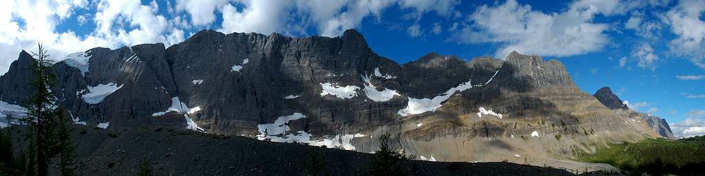
The Rockwall Trail in British Columbia’s Kootenay National Park is widely considered to be one of the premier multiday treks found anywhere. The 55.6 km trail leads one under 30 km of an almost unbroken wall of limestone cliffs towering 900m (2950 feet) above their base in places. In addition to the obviously majestic alpine scenery this massive limestone wall provides, the trail is also punctuated with hanging glaciers, stunning wildflower meadows, larch forests, one of the highest waterfalls in the Canadian Rockies, and three high alpine passes. When British backpacker Chris Townsend did his 1988 trek from the Canada/U.S. border north along the entire length of the Canadian Rockies, he described the Rockwall as the best trail he had walked in the mountain parks.
The Rockwall is the eastern escarpment of the Vermilion Range in the Canadian Rocky Mountains. The Vermilion Range and Kootenay National Park are representative of the ranges on the western edge of the Rocky Mountains.
The north end of the hike passes by ochre beds and paint pots which were used by the Ktunaxa, Stoney, and Blackfoot tribes to make dyes and paints used in ceremonies and for trade. Later, the Europeans also harvested the ochre from this area as a pigment base for paints (after the 1920’s, this activity was phased out with the protection of the land in mind). Also at the north end of the hike is Helmet Falls, one of the highest waterfalls in the Canadian Rockies at an estimated height of 352m (1154 feet). Originating from the meltwater of the Washmawapta Icefield, the headwaters of Helmet Creek almost immediately make their dramatic plummet to the valley floor at Helmet Falls. The falls themselves and mountain amphitheater it is situated in are truly breathtaking. At the south end of the hike is Floe Lake, an amazingly beautiful location named after the ice floes breaking off into the lake from the small glacier above it. Hiking between the Floe Lake Trailhead and Floe Lake take you through the burns of the 2003 fires and the regeneration which has been underway since. In between these highlights at the north and south ends of the trek, lies the Rockwall itself and possibly what hiking the trail is known best for – its continuous gain and loss of elevation. The trail is continuously rising and falling as it goes over three different passes - Rockwall Pass, Tumbling Pass, and Numa Pass. Tumbling Glacier and Wolverine Pass (a gap in the Rockwall leading to the west) are yet other remarkable sights found along the journey of the Rockwall Trail. Most everyone is expecting the amazing alpine scenery found along the trail, but perhaps not all will expect the impressive meadows of wildflowers which are common along the way. Particularly interesting is the variety of paintbrush which can be observed. Pink, pink and white, and even yellow paintbrush are to be seen. The trail really is one of the most spectacular backcountry destinations there is. It is a very popular trail in peak season, however, Parks Canada does limit the numbers of people on it at any time by only issuing a certain number of permits for the campgrounds.

The history of the Rockwall begins in 1923 when an outfitter by the name of Walter Nixon guided some dignitaries up to Tumbling Pass and Wolverine Plateau by horseback. Consensus among the group being that it was the most scenic ride in the alpine that they had ever done, discussion began on forming an organization which would give riders the opportunity to do rides like this themselves. The next year, with the support of the Canadian Pacific Railway (looking to broaden its draw of tourists to the mountains), the Trail Riders of the Canadian Rockies was formed. Nixon returned to the Rockwall area in the fall of 1924 to cut some of the first trail along this amazing escarpment to prepare for the organization’s planned ride there for the following summer. The area continued to grow in popularity as trails were established up the creek drainages leading into the range. Although known to some hikers and backpackers, the area primarily remained the playground of horseback riders for another four decades. In 1969, when the Rockwall Trail was included in the proposed plan for the Great Divide Trail, the area began its further recognition among hikers as the amazing trek in the mountains that it is.
The Rockwall Trail is most commonly done from south to north, however, there doesn't seem to be any particular reasonings behind this being the case. In fact, there can be a couple of arguments made for doing it north to south. For one, there is a slight elevation loss when hiking the trail in a southerly direction. The appeal of this factor may seem negligible, especially given all the passes that are gone over. Nevertheless, there is a net elevation loss when going south. Secondly, despite the incredible scenery along the entire length of the trail, some of the most beautiful sights lay waiting at the southern end of the trail. If there is a favourable weather forecast, you may wish to leave Numa Pass and Floe Lake until the end of your trip. Typically, people hiking the entire trail take 3-5 days to complete it. There are options to do smaller sections of the Rockwall Trail or to extend your trip to go beyond only the Rockwall. These options are discussed in “The Trail” section below.
The closest full service towns to the Rockwall Trail are Radium Hot Springs (just south of Kootenay National Park's southern entrance) and Banff (33km east of Kootenay National Park's northern entrance).
As mentioned earlier, the Rockwall Trail is part of the Great Divide Trail, a somewhat informal collection of trails, cut lines, and roads running 1198.4 km (745 miles) from Waterton Lakes National Park at the Canada/US border up to Kakwa Lake Provincial Park in BC (north of Jasper National Park). This incredible route crosses the continental divide a minimum of 30 times.
“Hiking Canada's Great Divide Trail” by Dustin Lynx
Getting There
The Rockwall Trail is accessed by one of four creek drainages to the east (Helmet Creek, Tumbling Creek, Numa Creek, or Floe Creek) or by Wolverine Pass from the west. For those doing the entire trail, you will either begin at the Floe Lake Trailhead (for those hiking south to north) or the Paint Pots Trailhead (for those hiking north to south). Both are located on Highway 93 South – the only major road running through Kootenay National Park.
If you are approaching from the Trans-Canada Highway, turn south at Castle Junction in Banff National Park onto Highway 93 South. Drive approximately 19 km to the Paint Pots Trailhead parking lot or a further 13 km to the Floe Lake Trailhead parking lot. Both parking lots are clearly signed.
From the south, take the turnoff into Kootenay National Park from the town of Radium. Drive to the northern part of the park, watching for the signs for the Floe Lake Trailhead or the Paint Pots Trailhead - depending on your chosen starting point.
The Rockwall trail is not a loop, however, after hiking its 55.6 km, you will only be 13 km from where you began. Two vehicles or hitchhiking will be needed to get you from one trailhead to the other.

The Trail
Topo map: 82 N/1 Mount Goodsir
Length: 55.6 km
Lowest Elevation: Floe Lake Trailhead on Highway 93 at approx. 1325 m (4350 feet)
Highest Elevation: Numa Pass Summit at 2355 m (7725 feet)
The Rockwall Trail is a distinct path which is easy to follow, provided that snow is not obscuring the trail. All junctions with other trails are clearly signed showing directions and distances. Five campsites are found along the way and there are rangers' cabins at Helmet Falls, Floe Lake, and near the Wolverine Pass junction.
Kootenay National Park Map (shows all campsites)
Hiking the entire Rockwall Trail is an incredible experience with new and exciting scenery everyday. However, trails starting from the highway that run up the Numa Creek and Tumbling Creek drainages allow for shorter trips or early exits if some need arises.
The following are descriptions of the trail from the perspective of starting at the Paint Pots Trailhead in the north.
(All distances are my best approximations as there is much contradictory information out there. Even in the case of adding up all the distances on Parks Canada maps, these distances do not correspond with their listed total distance for the trail. Nor do they correspond with their written descriptions of distances. After comparing all data out there with the maps and making it add up to a proper total distance, I feel pretty comfortable with the numbers I have given.)
Paint Pots Trailhead to Helmet Falls Campground
Distance: Approx. 14.7 km
Elevation Gain: 350 m (1150 feet)
If starting from the north, a first time hiker of the Rockwall may worry about doing the longest daily distance on the first day while carrying all their supplies needed for the entire hike. However, this should not be much of a concern. With only 1150 feet of gradual elevation gain, you may look back on this as being one of the easier days on the trip! Much of this day is spent hiking through the trees. You do get occasional views ahead to the mountains and Helmet Creek is certainly a beautiful creek to be hiking along.
From the Paint Pots Trailhead, cross the Vermilion River and follow the interpretive trail to the richly coloured paint pots. Stay left at the junction leading to Marble Canyon and stay right when the junction for the Tumbling Creek Trail is reached. As mentioned previously, all the junctions along the trail are well signed with directions and distances. Approximately 6 km from the highway, you will turn left onto the Helmet Creek Trail which will take you to the Helmet Falls Campground and eventually on to the Rockwall. Shortly after turning onto the Helmet Creek Trail, you will reach the first of the campgrounds along the way – the Helmet/Ochre Junction Campground. This campground does not receive the same traffic as the next four. You have not covered much ground yet and most of the hike done so far has been over relatively flat ground. For most, the Rockwall is beckoning and they must carry on. The Helmet/Ochre Junction Campground is a perfect spot to have lunch, rest the legs, and refill water bottles.
The Helmet Creek Trail ends at the junction of the Goodsir Pass Trail and the Rockwall Trail. Turn left and Helmet Falls Campground is only a short ways further. With a total vertical drop of 352m (1154 feet), Helmet Falls is certainly one of the surprises for many doing the Rockwall Trail. It is an amazing destination in itself. And the mountain amphitheater which surrounds it makes it all the more remarkable. Limestone Peak, Helmet Mountain, and Sharp Mountain frame the scene and it is worth getting up early to see these mountains as the first rays of light hit them in the morning. Above and out of sight, the Washmawapta Icefield and Glacier feed the waterfall.
Helmet Falls Campground to Tumbling Creek Campground
Distance: Approx. 12.5 km
Elevation Gain to Top of Rockwall Pass: 410 m (1350 feet)
Elevation Loss from Top of Rockwall Pass to Tumbling Creek Campground: 260 m (850 feet)
For those feeling motivated to do so, you can begin this day by taking a side trail that leads you right to the base of Helmet Falls. Take your backpacks and gear along when leaving the campground – the side trail to the waterfall branches off of the main trail. Shortly after this, the climb up Rockwall Pass begins. You hike through some nice stands of larch trees along the way. When you finally break out of the trees, you see the Rockwall for the first time and the incredible scenery which will accompany you all the way to Floe Lake. It really is an awesome sight. From here to Wolverine Pass, you have an uninterrupted wall of limestone rock to the west of you, culminating at Mount Drysdale at the southern end of the wall. Above the Rockwall and out of sight is the Washmawapta Icefield. Between Mount Drysdale and Mount Gray to the south of it is the one break in the limestone bulwark along the length of the Rockwall Trail. This is Wolverine Pass. Through it you can see the Purcell Mountain Range to the west of you. After hiking past Wolverine Pass, the trail makes its way downwards to the next in the line of beautiful campsites at Tumbling Creek.

Tumbling Creek Campground to Numa Creek Campground
Distance: Approx. 7.7 km
Elevation Gains to Top of Tumbling Pass: 335 m (1100 feet)
Elevation Loss from Top of Tumbling Pass to Numa Creek Campground: 715 m (2350 feet)
The scenery at the start of this day is dominated by Tumbling Glacier and the quite impressive lateral moraine showing how large this glacier used to be. After making your way up and over Tumbling Pass, there is a steep descent down the south side of the pass. You will encounter a few creek crossings here. For the most part, they are not problematic, however, hiking poles can always be useful in these situations.
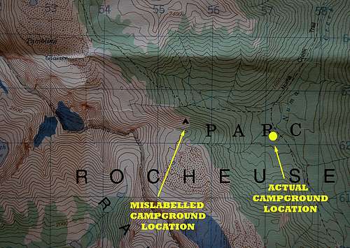
On the Mount Goodsir 82 N/1 1:50,000 topographic map, the position shown for the Numa Creek campground is incorrect. The map makes the campground appear to be located off the trail and indicates that it is to your right as you descend down the south side of Tumbling Pass. Ignore where the map says it is and continue down the trail. Carry on past the Numa Creek Trail junction and you will find yourself walking through the campground with no detours needed. There is even a sign at the Numa Creek Trail junction telling you which way to go and that you are almost there. For hikers coming from the south, there won’t be any issue as you will find yourself walking through the camp before you would even realize the map was incorrect.

Numa Creek Campground to Floe Lake Campground
Distance: Approx. 10.0 km
Elevation Gains to Top of Numa Pass: 755 m (2475 feet)
Elevation Loss from Top of Numa Pass to Floe Lake: 250 m (825 feet)
After spending the start of the morning in the trees, this day ends by going up and over Numa Pass, the highest point along the Rockwall Trail at 2355 m (7725 feet). The scenery is spectacular as you head up into the alpine, hiking between Foster Peak to the SW and Numa Mountain to the NE. Being up in the alpine, the trail going over Numa Pass is open and exposed to any elements the weather may throw at you. Snow will often linger on the trail here into late summer and can certainly reappear in early fall. Here, as with anywhere on the trail, precipitation in the form of snow can occur in any month of the year. Markers alongside the trail help people find their way for when there is snow in the higher reaches of Numa Pass. The name Numa comes from the Cree word for thunder. With that in mind, it seems fitting that Numa Mountain was previously named Roaring Mountain.
This section of the trail ends with the hike down to Floe Lake. If conditions are clear, the view down to the lake is stunning. Floe Lake, the last in the line of campgrounds along the trail, is a magical spot. Ice floes which calve off of the small glacier there can be seen in the lake and give the lake its name. It is the perfect spot to spend the last night on the trail.

Floe Lake Campground to Floe Lake Trailhead
Distance: Approx. 10.7 km
Elevation Loss: 700 m (2300 feet)
An interesting feature of this day is hiking through the burns from the 2003 fires and the regeneration which has taken place since. People should be alert to the hazard of treefall in these sections, especially when it is windy. If you find yourself fatigued on your hike down, do not get overly excited by the tease of the first sight of the highway – you have a long ways to go from that point!

Options for shorter trips: As has been mentioned more than once already, the trails in the Numa Creek and Tumbling Creek drainages connect the highway and the Rockwall Trail and allow for shorter trips or early exits if some need arises. Taking the Tumbling Creek Trail from the Rockwall Trail leads one back to the Ochre Creek Trail – essentially making a loop back to the Paint Pots Trailhead. The 6.6 km long Numa Creek Trail provides an easy access to the Rockwall Trail.
Options for longer trips: For those wishing to add some more distance to their Rockwall Trail experience, several options exist. The junction of Helmet Creek Trail and the Rockwall Trail in the north is also the junction for the Goodsir Pass Trail leading into Yoho National Park. Many hikers will simply hike to Goodsir Pass from the junction for the views to be found there and then return to continue their Rockwall trip. Or for a more adventurous alternative, the hike can be started in Yoho for those heading south, or ended in Yoho for those going north. After going over Goodsir Pass, there is the option of continuing on to the Trans-Canada Highway following the Ottertail River or cutting towards the north and on to McArthur Pass and the Lake O'Hara area.
Hikers wanting to continue on from the southern end of the Rockwall Trail can cross Highway 93 at the Floe Lake Trailhead and hike up the Hawk Creek Trail to Ball Pass on the border of Banff National Park. From Ball Pass, the hiking options that can be accessed in Banff National Park and Mount Assiniboine Provincial Park are too numerous to mention.
The ultimate continuation is to do the Rockwall Trail as part of the Great Divide Trail, a somewhat informal collection of trails, cut lines, and roads running 1198.4 km (745 miles) from Waterton Lakes National Park at the Canada/US border up to Kakwa Lake Provincial Park in BC (north of Jasper National Park).
Alternative Access to the Rockwall Trail: Wolverine Pass
Permits, Red Tape, & Other Useful Information
Everyone doing the Rockwall Trail needs a backcountry camping/wilderness permit for each night they are on the trail. As of 2011, these permits were $9.80/person/night (annual permits are also available for purchase). There is also a non-refundable application fee of $11.70 for the whole group. This fee is not charged if you make your booking the day you are beginning your trip. However, reserving campsites ahead of time is strongly recommended due to the popularity of the trail and the quota put on the number of hikers on the trail by Parks Canada. Parks Canada imposes these quotas to enhance the experience of hikers and to minimize the environmental strains put on the area. Reservations may be made as much as three months in advance of your trip. Groups sizes can be no larger than ten people.
To reserve and purchase permits, Kootenay National Park's contact information is:
Telephone: 250-347-9505
E-mail: kootenay.info@pc.gc.ca
Furthermore, upon arriving at the park, a park entry pass will need to be purchased for everyone in the group.
A breakdown of the fees charged by the park can be found here:
Kootenay National Park Fees
There are no requirements to formally check in with Parks Canada before and after your trip. However, if you do fill out a Voluntary Safety Registration at a Parks Canada Visitor Centre beforehand, then you are required by law to register your return upon finishing your trip, so as to prevent a costly and unnecessary search.
Dogs are allowed on the Rockwall Trail, but they must be on a leash at all times.
Bikes are not allowed on the Rockwall Trail.
Campfires are not allowed anywhere on the trail, with the exception of the Numa Creek Campground.
Pack out everything you bring in- including garbage, food waste, diapers, tampons, and sanitary napkins. Simply put – you pack it in, you pack it out.
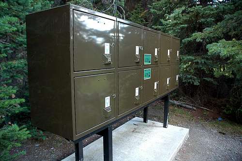
Do not approach or feed wildlife – large or small. It is against the law to feed any wildlife. It negatively affects their health, their natural behavior, and exposes yourself to potential danger. When at the campgrounds, keep all food and items with scent (i.e. toothpaste, garbage) in the metal cabinets provided.
Leave natural things as you found them for others to enjoy. By law, you are not allowed to remove rocks, fossils, wildflowers, or any other natural artifact you may find from the park.
Obey any closures due to safety or environmental reasons.
Firearms are not allowed on the trail.
Anglers require a National Park Fishing Permit.
Help the parks and call 1-888-WARDENS if you see anyone violating park regulations.
Other Random Things to Know
I have purposely chosen to limit the scope of this page and to not try to make it a comprehensive blueprint for all the preparations needed and all the essential gear required for taking on a multiday hike. Many books and websites exist out there for this purpose and that information will have to be found elsewhere. Nevertheless, here are some extra tidbits of useful information that go beyond that found in the regulations basics spoken about above.
Leave a detailed itinerary of your plans with either friends or family including an estimation of when you expect to finish the hike. Also provide them with contact information of who to contact in the scenario that you are not heard from when expected. As mentioned above, there are no requirements to formally check in with Parks Canada before and after your trip. However, if you do fill out a Voluntary Safety Registration at a Parks Canada Visitor Centre beforehand, then you are required by law to register your return upon finishing your trip, so as to prevent a costly and unnecessary search.
Water sources are numerous along the trail, including at all the campsites. Nevertheless, be prepared for your needs for the trail ahead – especially when hiking up the passes. A water filter is needed for the trip. Many of the creeks are quite laden with silt and water filters may need to be backwashed a time or two during the trip.
Plan clothing for every weather condition and base these plans on dressing in layers.
Don't forget your permits!
Hiking poles can be useful for creek crossings and saving your knees on longer treks.
Kootenay National Park is bear country. Be knowledgeable of and take all normal precautions for traveling in these animals' territory. Make ample noise as you hike, especially around noisy creeks. Store all food and items with scent (i.e. toothpaste, garbage) in the metal cabinets provided at the campgrounds. If you take bear spray or bear bangers with you, be familiar with how to use them. Always do any food preparation away from your tent.
Report any bear, cougar, or wolf sightings, as well as any aggressive behavior by any wildlife to the nearest Park Warden Office or Information Centre.
Kootenay National Park Visitor Safety Information
Campgrounds
There are 5 campgrounds along the length of the Rockwall Trail. From north to south they are: Helmet/Ochre Junction, Helmet Falls, Tumbling Creek, Numa Creek, and Floe Lake. Realistically, the Helmet/Ochre Junction campground does not receive the traffic of the other sites. In my opinion, it is best used as a great spot to stop for lunch before carrying on to Helmet Falls (if hiking south). All of the campgrounds are located right on the trail and can’t be missed.
Kootenay National Park Map (shows all campsites)
On the Mount Goodsir 82 N/1 1:50,000 topographic map, the position shown for the Numa Creek campground is incorrect. The map (shown below) makes the campground appear to be off the trail and quite far from the actual location of it. Coming from the north, ignore where the map says it is and carry on past the Numa Creek Trail junction and you will find yourself walking through the campground with no detours needed. There is even a sign at the Numa Creek Trail junction telling you which way to go and that you are almost there. For hikers coming from the south, there won’t be any issue as you will find yourself walking through the camp before you would even realize the map was incorrect.
Each campground is equipped with outhouses.
All of the campgrounds have cooking areas that are separate from the tent sites. The cooking areas have metal bear cabinets to store food and anything with scent (i.e. toothpaste, garbage) in.
Each campground has a water source nearby.
There are no fires allowed at any of the campgrounds with the exception of Numa Creek.
During the peak hiking season (late July and August), getting reservations in advance for any of the campgrounds is highly recommended.
Weather, Trail Conditions, & When To Do
July to mid-September is the best time to hike the Rockwall trail. This of course can vary, depending on the specific conditions of any given year. Snow can occur in any month and hikers need to be prepared for all conditions. Above 1500 m (approx. 5000 feet), freezing temperatures are not uncommon, even in summer. Being on the western edge of the Rockies, the climate is mostly determined by the moist air moving in east from the Pacific coast. Summers are generally short and cool, however hot spells do exist.
Environment Canada Weather Forecast
Kootenay National Park Trail Conditions
Kootenay National Park Contact Information
External Links
Kootenay National Park
Kootenay National Park Map
Friends of the Great Divide Trail