
-
 4929 Hits
-
 81.18% Score
-
 13 Votes
|
|
Route |
|---|---|
|
|
50.75330°N / 115.0917°W |
|
|
Mountaineering, Trad Climbing |
|
|
Summer, Fall |
|
|
A long day |
|
|
5.6 (YDS) |
|
|
Alpine II |
|
|
1 |
|
|
II |
|
|
Overview
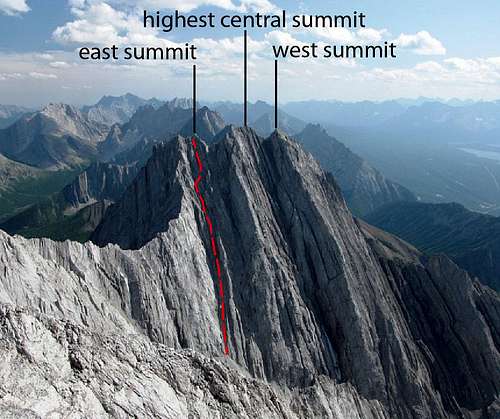
Mount Packenham is a striking tower next to Mount Evan-Thomas in the Opal Range of Kananaskis Country. The 3000 metre (9,843 ft) summit of Mt. Packenham shares a jagged and sharp col with the King of the Opals, Evan-Thomas.Getting There
Easy highway access from Highway 40 along the western edge of the Opal Range provides the best approach. Highway 40 does provide access from the Trans Canada Highway in the north, and continues south to the Longview area, but the southern section is closed for wildlife protection from December 1 to June 15 each winter/spring. Best vehicle access from Canmore/Banff or Calgary is via the Trans Canada Highway, south along Highway 40.Park in the ditch beside Ripple Rock Creek, not signed, approximately 45 km south of the Trans Canada Highway. Ripple Rock Creek is 1 km south of Grizzly Creek, which has a highway sign, and 1 km north of the signed Hood Creek.
When to Climb
Typical Canadian Rockies situation with July and August providing the driest conditions. Later summer and early fall (October) can provide dry conditions. If a party desires a snow climb up the north gully then an ascent from late May to late June would provide best chance of safe and stable conditions.Approach
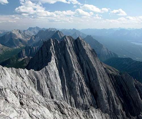
The trail to Grizzly Col and GR 328248, “Grizzly Peak” provides fast and quick access to tree line and the meadows of upper Ripple Rock Creek. About halfway between tree line and Grizzly Col (about GR 330245) head due east; easy travel through steep alpine meadows. Continue eastwards into a tight basin between Mt. Evan-Thomas and Mt. Packenham. At the far eastern edge of the basin, take the tallest and most eastern scree cone towards a long gully system on the north face of Mt. Packenham. This gully system will provide rubblely access to the eastern summit and summit ridge.

|
 |
 |
|---|
Climbing History/Route Description
In 1954 M. Dixon, N. Gish, S.G. Pearson and P. Rainier reported in the Canadian Alpine Journal they had ascended Mt. Packenham, but their 1954 register has found on the summit of Mt. Evan-Thomas by Glen Boles on his ascent in the early 1970’s. The credit for the first ascent of Mt. Evan-Thomas is now given to Dixon’s party.The 1972 ascent by J. Pomeroy, M. Simpson and D. Forrest and G. Boles is described as the North-West Face, North Ridge. The exact location and line of this route is difficult to discern from this description. The North Ridge would originate from the shared col with Mt. Evan-Thomas, not sure if this is the route described. Quotation below
"June 1972. From highway up grass slopes, traverse around hump to col then up grass and shale ridge to base of peak. Traverse north under North West buttress; then turn up a series of gullies and cracks, some good rock, to a subsidiary peak 2695m; downclimbed and a rappel to col. Follow North West ridge a short way, then traverse up left across North West face to North Ridge. Good rock to summit. D. Forest descended a notch and climbed a slightly higher summit 90m to East. Descend to col, then snow gullies down North West side to head of creek”
On July 1, 1987 Rick Collier and Bob Saunders climbed the “North Couloir and East Ridge”, Rick identifies this as a separate line different from the first ascent. Quotation below
“Bob and I hiked to the end of the valley on the N side of this massif, and ascended the major N couloir from the top of an obvious scree cone. After 250' of scrambling, we traversed right into the first major branching couloir; the climbing is mostly fourth class all the way to the summit ridge. Once on the ridge, one traverses easily back W toward the summit block, which requires a short pitch to surmount. This is likely a variation on the descent route of the Pomeroy, et al., party of 1972.”
Orvel Miskiw and Allan Main climbed the north gully when it was continuous snow to the summit ridge in July of 2000. Orvel’s report indicates they stayed in the gully (couloir) all the way to the summit ridge and then traversed west to the highest summit.
I would guess the Boles/Forest team reached the western summit first since Don had to head east to climb a slightly higher summit, I would assume the highest central summit. Collier's guess is likely correct that his team climbed their descent route.
My best guess is that Collier’s party exited the main gully (couloir) earlier than Miskiw’s party on his ascent. As you gain elevation in the gully, minor gullies do deviate from the system. I do believe that Collier/Saunders and Miskiw/Main climbed the same eastern face on the final summit block to the central summit. Andrew and Mark Nugara climbed the same route as Miskiw/Main, but without snow. Rafal Kazmierczak and I (Kevin Barton) climbed the same route as the Nugara brothers, but I am sure we took a more left gully line nearing the top, which did require us to traverse back right just below the summit ridge. Based on our observation, the more left (east) gully contained more solid rock then the right branch. Both the Nugara’s and I climbed the same summit block as Collier and Miskiw. There is a rumour of an ascent of the West Ridge, but I cannot confirm this. Even though I am sure the Boles/Forest team took a different line that other ascents, I have only indicated one route, as I believe the above mention climbs are only variations on the same face.
|
 |
|---|
- North Gully, East Summit Ridge, Alpine II, 5.6
At the far eastern edge of the basin, take the tallest and most eastern scree cone towards a long gully system on the north face of Mt. Packenham. This gully system will provide rubblely access to the eastern summit and summit ridge. This gully is over 400 metres from the top of the cone to the summit ridge. Stay in the primary gully as you ascend, when slight diversions are encountered, stay to climber’s left.

|
 |
 |
|---|
Near the summit ridge (about 70 metre below the ridge), the left most gully does steepen considerably, traverse right in the next major gully (very obvious gully). Then follow this gully to the summit ridge. You exit on the eastern summit tower.

|
 |
 |
|---|
Head west towards the highest, central tower. Difficult scrambling (Class 4) on loose and exposed rock takes you the low point between the eastern and central summits. From this minor col to the summit the climbing is mostly lower 5 class, mostly about 5.2. About 30 metres below the summit, a steep wall is encountered.
 Route marked on summit block
Andrew Nugara climbed the wall directly on a 5.6 nose and then 5.4 slab up to the summit block. I had started up this line, as it was directly above my piton belay station, I got in a bomber #6 wire about 5 metres up, but the remaining 20+ metres of 5.4 slab look blank without any protection. I retrieved by wire and traversed far right (5.4) to a small pinnacle, access to get behind the pillar was three or four strenuous 5.6 moves, but I was well protected by a bomber piton. Once between the pinnacle and the summit the grade was easy, maybe 5.2. Turns out this is the same line that Orvel Miskiw took up the summit block.

|
 |
 |
|---|
I built a quick piton station and bought Raff up, easy walk up final 30 metres to the summit. There was a small summit cairn, but I couldn’t find any register. Leaving, I belayed Raff’s downclimb to the lower station, then removed my piton station and downclimbed with a belay from below, cleaned the piton and meet Raff below. I again belayed Raff’s downclimb and removed the station. We left nothing on the mountain, no slings or pitons. We easily downclimbed the return to the north gully. Descend gully back to scree fields.
Essential Gear
60 metre climbing rope, a full set of wires, pitons (only used KB’s) and a hammer. Cord or webbing for stations. Helmet of course, poles are very helpful for the scree bash. We did encounter several small patches of ice in the upper gully, so depending on the month, crampons may be required. We did not leave any slings, cord or pitons on the mountain, we did not find any old tat or fixed gear, so be prepared to create your own protection.Rain/snow storm shell, warm jacket, waterproof climbing boots and good food as required, based on weather or season.
Reference
Boles, G.W., Kruszyna R. & Putnam W.L. (1979). The Rocky Mountains of Canada South. 7 th edition. New York: American Alpine Club, Alpine Club of Canada.Out of print
Collier and Miskiw trip reports online at bivouac.com