Overview
Tombstone Mountain is a substantial peak with a long and complex summit ridge in the
Opal Range of Kananaskis Country. The 3029 metre (9,938 ft) summit of Tombstone Mountain has several prominent towers along the summit ridge with large tilted slabs. Named in 1884 by the explorer Dr. Dawson, assumedly for these slabs that resemble tombstones. There is a significant southern outlier GR 407165 locally referred to as
“Tombstone South” which recently has become very popular with scramblers. A mislabelled summit on the official topographic map has created confusion about the location of the summit. Although very difficult to discern from the summit, and from surrounding peaks, the northern most highpoint is considered the true summit of Tombstone Mountain; about 1.5 kilometres North West of where it is marked on the official map (82 J/11). The North Ridge route is mostly a scramble (difficult and loose 4th Class) with only a short summit notch that requires low 5th class climbing.
Getting There
Easy highway access from Highway 40 along the western edge of the
Opal Range provides the best approach. Highway 40 does provide access from the Trans Canada Highway in the north, and continues south to the Longview area, but the southern section is closed for wildlife protection from December 1 to June 15 each winter/spring. Best vehicle access from Canmore/Banff or Calgary is via the Trans Canada Highway, south along Highway 40.
Access to the parking area, Elbow Lake trailhead, is affected by the road closure is not accessible by motor vehicle from December 1 to June 15. Park in the Elbow Lake parking lot, approximately 62 km south of the Trans Canada Highway. To gain the North Ridge of Tombstone Mountain you need to access upper ‘Piper Creek’ (unofficial name), which can be difficult as there is no official trail and a significant river crossing. Once in the upper drainage of ‘Piper Creek’, head north towards a high col (outlier of Mt. Jerram and Tombstone Mtn. col) about 5 kilometres from river crossing of Elbow River.
When to Climb
Typical Canadian Rockies situation with July and August providing the best conditions for high elevation climbing. Tombstone Mountain’s position in the dry front ranges extends the summer season and is usually dry from June to late October.
Approach
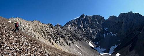
An excellent trail heads north/south in the ‘Piper Creek’ valley (I suspect pounded in by the numerous backcountry guided horse trips in the surrounding valleys). The trail is on the north creek bank, best way to find this trail is to head north (light bushwhacking) taking a straight line to the South Ridge of Tombstone South (GR407165). Cross ‘Piper Creek’ and keep heading north until you intersect the trail. Once on the trail, follow it north/north west upstream.
Depending where you intersect this trail, head up valley for about 2 kilometres, and at tree line, head to the obvious high col (outlier of Mt. Jerram and Tombstone Mtn. col), about 5 kilometres from river crossing of Elbow River to col. From col either drop to small tarn north of col, a loss of about 200 metres (650 ft.), or try to find an path to contour below the sharp West Ridge of Tombstone; dropping to tarn is recommended. On our return, we found a scree gully along the West Ridge that dropped into the scree basin east of the col that saved elevation loss/regain. This gully might be difficult to find on the approach; recommend heading to col, tarn, then slog up North-West scree slopes to North Ridge.
Route Description
First ascent of the mountain was in September 1975, by coincidence both the North and South summits were climbed the same day. The North summit is the highest point and the true summit. North summit first ascent by E. Grassman & party. Climbed from ‘Piper Creek’ (unofficial name of creek between Tombstone Mountain and Mount Elpoca) to Jerram-Tombstone Col, traversed northward, up scree to North Ridge, ridge to summit. First Ascent of South summit by D. Forest, M. S. Forest. R. McGee, L. Michand, G. Boles & L. Kubbernus via South Ridge.
- North Ridge, North Tower, Alpine II, 5.4
![]() |
![]() |
| This route is mostly a walkup, then a long section of fun 4th Class scrambling and a short 5th Class summit section. From the col I recommend dropping north to the tarn. From tarn head west and gain easy scree slopes and plod up with quick elevation gain. Nearing the North Ridge, we gained a short West Ridge stub from the main summit ridge. A bit of exposed and awkward 4th class terrain gains the true North Ridge. Once on the summit ridge trackle the ridge crest head on for the best rock. A series of slabby ridges (difficult 4th Class) and flat scree sections alternate for a few hundred metres. Kevin nearing end of scree slog (l) 4th Class scrambling on North Ridge, Andrew scrambles, Kevin waits turn (r).
|
![]() |
![]() |
| Views from the short West Ridge stub. Main summit in sunlight, summit notch is visible, two southern summits towers in shade. View to summit notch (l) Southern two summit towers of Tombstone Mtn. West summit on far right of summit ridge (r).
|
![]() |
![]() |
|
Follow North Ridge with exposed and loose difficult scrambling (4th Class). Sections of loose rock on North Ridge (l) Sections of solid rock (r).
|
![]() |
![]() |
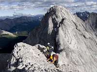
| After a few hundred metres of scrambling, the summit notch is reached. After some exploratory and difficult downclimbing, I climbed back up and set up a rappel. Once in the bottom of the notch, the final summit section is about 35 metres of 5.3 to the summit tower, solid slab, but little protection. I used a nice big boulder on a protuding ledge just below the summit for a belay station. We also rappelled off this station on the descent (left cord in place). Kevin (OSWB) raps into summit notch (l) Kevin leading the start of the only ascent pitch (5.3) to summit (r).
|
![]() |
![]() |
| From this station, easy terrain to summit. Andrew seconds 5.3 pitch out of summit notch (l) Kevin belays Andrew the final steps to summit (r).
|
![]() |
![]() |
| The North Tower Summit is a sharp ridge with little purchase. Summit shot Kevin and Rafal (l) Top of North Summit Tower in centre (sunlit point), Southern two towers beyond. Lower West Summit in shade on lower right. (r).
|
![]() |
![]() |
| From station just below summit, rappel back into notch. The climb north out of the notch is the crux, 5.4 mostly good rock, but lots of loose sections and little opportunity for protection. Kevin waits in summit notch, climbing crux over Kevin's head (5.4) (l) Andrew begins to scramble and Kevin coils rope on northern (return) side of summit notch. (r).
|
![]() |
![]() |
| Descend North Ridge as the ascent route, head back to scree slopes along north west slope. We did find a steep scree gully on descend that saved elevation loss/gain required by dropping to lake. This gully may be hard to find. Andrew and Kevin descending scree low down on North West Slopes of Tombstone Mtn. (l) Access to col is to left on brown scree, our descent scree gully was located in the scree basin to right in the darker cliff bands near change in scree colour (r).
|
Essential Gear
60 metre climbing rope and cord or webbing for stations. We brought a full set of wires and a dozen or so pitons and a hammer, but didn't use much of it (maybe one wire on 5.4 section?); but some parties may want to protect sections of ridge. Helmet of course, poles are very helpful for the scree bash. We slung boulders for our summit rappel, but be prepared to create your own stations.
Rain/snow storm shell, warm jacket, waterproof climbing boots and good food as required, based on weather or season.
Reference
Boles, G.W., Kruszyna R. & Putnam W.L. (1979). The Rocky Mountains of Canada South. 7 th edition. New York: American Alpine Club, Alpine Club of Canada.
Out of print

 4331 Hits
 84.4% Score
 19 Votes