
|
|
Mountain/Rock |
|---|---|
|
|
40.65950°N / 110.27°W |
|
|
Duchesne |
|
|
Hiking, Mountaineering, Scrambling, Skiing |
|
|
Summer, Fall |
|
|
12194 ft / 3717 m |
|
|
Overview
Flat Top BM (Benchmark) is another 12,000+ foot peak in the Uinta Mountains. Because it sits south and on the same ridge of the much higher Mount Emmons (the 4th highest peak in Utah), it doesn’t get much attention and is seldom visited. The peak is surrounded by many other peaks and is also surrounded by beautiful lakes and meadows.For the most part the peak is a gentle dome and is the southernmost peak in the Uinta Mountains to exceed 12,000 feet. The peak is seldom climbed even though it isn’t very rugged. Even so, climbing the peak can be challenging because of all the blowdowns in the area. Because the surrounding peaks are gentle and close together, you can climb many peaks on a single trip and you can even follow the ridge from Flat Top BM all the way north to Mount Emmons.
Most of the trails around Flat Top BM are not used much, and many are fading away because of very light or no foot traffic, therefore this is a good place to go come to if you enjoy solitude. Many trails are shown on the topo maps, but many of them don't exist anymore.
Like all peaks in the Uintas, except for Bald Mountain, Flat Top BM has no trail to the summit. It can be climbed on a long day trip, but the area is surrounded by many nice backcountry campsites in the basins and around the fishing lakes.
The Uinta Mountains are one of the few mountain ranges in North America that run east to west rather than north to south. Within the Uinta Mountains are about 2000 lakes, and some 900-1000 are full of trout. Along with the San Juans in Colorado, the Uintas have more contiguous area above timberline than any other area in the Continental United States. This is a beautiful area with many lakes, meadows, wildflowers, and some rugged peaks. Solitude is usually easy to come by once you leave the popular fishing holes behind.
The Uinta Mountains are very rugged in the northeast section. Beginning at Hayden Peak and east to Mount Lovenia, the Uintas are not unlike the Tetons or other ranges. East of Lovenia, the peaks are more gentle, with a few rugged peaks (ie Red Castle and Henrys Fork Peak) scattered about until you are as far east as the Henrys Fork/Kings Peak area. East of Kings Peak, the Uintas become very gentle and the peaks are very rounded with only a few scattered cliffs about.
Utah's 12,000+ Foot Peaks With 200+ Feet Prominence
Utah's 12,000+ Foot Peaks With 300+ Feet Prominence
 The gentle dome of Flat Top Benchmark.
Getting There
Dry Gulch TrailheadFirst drive to the town of Duchesne, which is along US Highway 40. From Duchesne, turn north onto State Highway 87. Follow State Highway 87 until it joins with State Highway 134 (this is where state Highway 87 heads due east instead of continuing north) between milepost 15 and 16. Follow State Highway 134 north to the little town of Mountain Home. Where State Highway 134 begins to head due east at Mountain Home, Continue north on the Moon Lake Road. After five miles, turn east on the Yellowstone River Road and to the Yellowstone River Power Plant.
From the Yellowstone River Power Plant, drive north along the Yellowstone River Road to the first major road heading east (right). With a map in hand, follow this gravel road east to Dry Gulch. From Dry Gulch, turn left and follow the road north through Dry Gulch to its end.
 The Lily Lakes Trail from Dry Gulch.
Uinta River Trailhead
From the intersection of Highway 121 and Highway 40 in the town of Roosevelt in the Uinta Basin, drive west on 200 North (Highway 121). Stay on Highway 121 as it quickly bends to the north. Most junctions are marked with signs, but they are very hard to read in the dark. At mile 9.9, just after the actual mile marker 10 at a stop sign, at the hamlet of Neola go straight towards Uintah Canyon. At mile 16.7 continue straight. At mile 18, turn right to Uintah Canyon. At mile 21.9 turn right. At mile 22.2 turn left just after the bridge. Park at the trailhead at mile 25.6.
Routes Overview
Dry Gulch RouteThis route is very seldom used and the trails marked on the map bear no resemblance to reality. The area has several long faded trails and a few old logging roads, but no marked trails. To complicate things, sometime before 1997, a huge storm caused a blow-down of several of the trees around the area south and east of Bollie Lake, which obscured what old trails there were. The route description will be rather brief as you must be able to route-find on your own to follow the route. A GPS comes in very handy in the forest.
This route follows and old track to Heller Lake and then follows an off trail route over into the drainage that is west of Jefferson Park and then to Bollie Lake.
From the lake, the route heads heads north to the ridge over to the Flat Top Benchmark.
The Dry Gulch Route is 19 miles round trip and can be done in one very long and hard day, but at least two days is recommended.
Other Routes
Old maps show a trail from near Sheep Bridge on the Uinta River to the creek east of Bollie Lake. I haven’t tried this route, but it is probably about equal in difficulty with the Dry Gulch Route and could be interesting for someone looking for an adventure.
The Uinta River Route should take about the same time is needed when climbing Flat Top BM from the Dry Gulch Route.
 Lost BM and Flat Top BM from the north.
Red Tape
No permits are required. Normal wilderness rules apply.Camping
There are many informal campsites near Dry Gulch.There are many backcountry campsites along the trails. Some of the best ones are are at Lily lakes and Bollie Lake, but there are plenty of other meadows scattered about.
 Flat Top BM is surrounded by meadows. This one can be wet, but there are many other places to camp around its edges.
Fishing
Bollie and Lily Creek Lakes have great fishing.The Uinta River and Swift Creek have great fishing as well.
When to Climb
Mid-July through Mid-September is the normal hiking season.In winter the road is opened to within 4 miles of the Swift Creek Trailhead. This is the only practical way in for a winter climb unless you have a snowmobile.
The road to the Dry Gulch Trailhead is closed in winter.
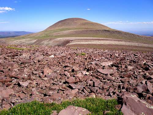
 In summer, the summit is a sea of rocks.
Mountain Conditions
Information regarding the conditions for climbing Mount Emmons can be obtained from Wasatch-Cache National Forest, 8236 Federal Bldg., 125 S. State Street, Salt Lake City, UT 84128, (801)524-3900.Weather Forecast for Central Uinta Mountains
Here are some average highs and lows from the 12,139 foot elevation (3700 meters) in the Uintas (about the same altitude as the summit):
| MONTH | HIGH | LOW |
| JAN | 14 | -1 |
| FEB | 16 | 1 |
| MAR | 19 | 4 |
| APR | 27 | 11 |
| MAY | 35 | 18 |
| JUN | 45 | 25 |
| JUL | 55 | 32 |
| AUG | 53 | 31 |
| SEP | 45 | 24 |
| OCT | 34 | 15 |
| NOV | 22 | 8 |
| DEC | 17 | 3 |