
|
|
Route |
|---|---|
|
|
45.37360°N / 121.6925°W |
|
|
Glacier approach, with three steps/pitches of wate |
|
|
Most of a day |
|
|
Grade III |
|
|
Approach
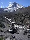
If possible, start from the Cloud Cap trailhead, at about 5800 feet, via the Cloud Cap road. If the road is gated, you must approach from the lower Tilly Jane ski trail, at about 3200 feet.
Once at the Cloud Cap Parking lot, follow the Timberline trail signs, and at the branch that forces you left or right, turn right, and this will take you to the moraine trail that follows the top of the ridge above the Eliot Glacier drainage. Turn left, and start ascending the top of the ridge; the mountain will be staring you in the face. After about an hour or less on the ridge, you'll come to a very large cairn (obvious) just to the right of the trail. Drop down there; there'll be a reasonably obvious footpath that diagonals down to the Eliot Glacier itself.
 |
Route Description
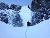
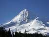
Once on the Eliot, climb up next to Cooper Spur which will be above you, and to the left. Stay close to the Spur, and keep an eye out for falling rock from above you. Crevasses will be off to your right hand side. Ahead of you, on the mountain, you'll see two gullies cutting down the North Face (actually, it's on the NE Face of the mountain; it's just what it's called) with a rib that separates them. That's what you're headed for.
A prominent rock prow comes down from the left rib of the left gully, to the Eliot glacier, so you want to be on the other side of that. Once you're at 8800 feet on the left side of the Eliot, you'll be forced to curve right, and that's when you'll traverse right, above crevasses, and below that rock prow. Turn up and left and you'll see the two ice pitches above you, and a bergschrund below them (sometimes two; be on the lookout for multiple cracks), and that's what the start of the route is.
At this point, once you get past the 'schrund, (I got around it on the left, close to the rock, but others have gotten across snowbridges, or skirted it on the right), pick your battle. The left flow of ice above you is very steep, almost vertical, and leads to the left, less steep, gully on the NF. The right flows of ice have two shorter steps, and leads to the steeper right gully. The left gully has two bulges of ice in it, I believe, but very short ones. The right gully, the steeper one, has only one more at the top of it, on the left hand side of a large rock wall/band. About 20-25 feet, and near vertical when we did it. Once above the ice in the left gully, escape left to the top of the Cooper Spur route, and follow that to the summit ridge. In the right gully, above the last of the ice, escape right to get to the summit more directly; you might climb around non-techical rock, or through a bit to get to the summit.
Once on the summit, descend the Sunshine Route to get back to your car. Or, do a shuttle, descending the well known South Side, and having a car stashed at Timberline Lodge the night before (that's what we did).
 |  |  |  |  |
Essential Gear
6 ice screws, or so (stubbies work good for this route; lots of smears of ice on rock). Two technical tools, or being comfortable climbing ice with a standard axe and a technical tool. Slings, a handful of small nuts and cams (don't bring too much, just a small amount). A picket-a-person. Spare biners and slings. Plan on spending 10-12 hours on route to the summit.
Miscellaneous Info
If you have information about this route that doesn't pertain to any of the other sections, please add it here.
Chad A. - Jan 11, 2005 11:22 pm - Hasn't voted
Route CommentCheck out "Oregon High" by Jeff Thomas for an accurate description on the route. Should've included that earlier.
chrisc - May 3, 2019 3:43 pm - Hasn't voted
Trip Report- Right Hand Gully May 2019Summited May 2019. Trip report here.