")
-
 40088 Hits
-
 74.01% Score
-
 4 Votes
|
|
Route |
|---|---|
|
|
45.33039°N / 121.70936°W |
|
|
Hiking |
|
|
Non-Technical |
|
|
Warning
Despite the fact that the trail is now open again, I am going to leave the details of the closure on this site so people can understand how dynamic and unstable parts of the route are. The soil, especially in the river canyons, is like a mix of loose sand and small rocks. Washouts like the one that are described below have happened many times in the past and will happen again in the future. Please, be safe going into and out of these river crossings.
September 2021 - After the crazy year 2020 (wind, fires, etc.), we are still dealing with issues on the Timberline Trail. Visit this link for details on a section that suffered the worst effects of the 2020 Labor Day Windstorm --- https://storymaps.arcgis.com/stories/f5d657a3b01d48d2b2696be821dc8373
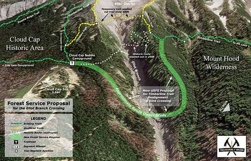
October 2016 - Good news! The Timberline Trail has been officially reconnected and re-opened. It is a bit longer than the original route but the new crossing of Elliot Creek will be safer (no bridge however, so be careful) and not as high on the mountain (so less impacted by the forces of Winter). Here is what the Oregonian had to say about the opening:
"The 1.5 mile re-route takes hikers farther south, to a safer crossing of the Eliot Branch. There is no bridge at the crossing, so hikers will need to be comfortable with river crossing to hike it, according to forest officials. Wilderness permits are also required to hike the loop from May 15 to October 15, made available by the Mount Hood National Forest."
Oregon Public Broadcasting included a nice explanation of why this re-routing of the trail was so important. Mentioning loose boulders this size of Volkswagen buses might be thrilling to some people but if you have ever seen the sand and scree on this side of Hood, you'd know what that is so scary.
Salem's Statesman Journal also had good information about the reopening of the route.
August 2016 - Trail conditions around the washout are still not good. The rocks and boulders suspended in the loose, sandy soil can come rolling down at any time and entire embankments can collapse above you as you scramble up, burying you as you try to exit the washout. The following trail report (submitted by a trail runner in mid-August) illustrates how difficult crossing that area still is:
"The most technical and challenging part of the run was crossing the Eliot Glacier washout near Cloud Cap. About 10 years ago there was a massive landslide that took out the trail and created a stunning canyon in the process. Without taking [the very long] detour, the only option was to CAREFULLY cross the canyon. The soil was extremely sandy and unstable, with every footstep sending rocks and boulders cascading down the hillside. Even rocks the size of a desk were not guaranteed to stay put once disturbed. After some searching, we found the safest place to descend the south canyon wall. A rope had been installed for assistance… but it had unfortunately been cut by someone recently (!). Upon reaching the bottom of the washout, there was another slippery river crossing over rapids. Getting up the other side of the washout was exhausting and frightening. The soil was again sandy and loose, but quite a bit steeper than the other side. About half-way up, we found a rope to make the final (very) steep climb up over the lip of the canyon wall. So glad to make it out unscathed!"
 OregonLive Graphic
But there is good news as of Aug. 2016 - Timberline Trail Is Finally Being Reconnected
2014 - The condition of the trail is once again subject to change based on natural weather events and willingness (or lack thereof) on the part of the authorities to rebuild and maintain the infrastructure that supports the trail; for example read the following article: Ramona Falls Trail still may be dangerous; washed-out footbridge may not be replaced soon. While this is not directly on the route (see Ramona Falls map), it is very close and serves as a good example of the ever changing risks of this area. If you have beta about the Timberline Trail please comment on this site.
2007 - The route is out of service due to a massive landslide. Repairs are not being undertaken as of July, 2007 due to the nature of the landslide. See article...
Mt. Hood's Timberline Trail Tumbles Thursday, July 12, 2007 / MICHAEL MILSTEIN / The Oregonian Staff
The massive collapse of glacial debris last winter wiped out a crucial stretch of the Timberline Trail around Mount Hood, and U.S. Forest Service officials don't know whether or how they will repair it. The damage, which emerged when snow melted, severs one of the most popular hiking circuits in the Cascades. Hikers trying to complete the 41-mile loop will find a steep drop-off hundreds of feet high where the trail used to traverse below Eliot Glacier on Mount Hood's north side. The remaining slope is so unstable and dangerous, there's no way to rebuild the trail, said Kevin Slagle, who manages recreation in that section of the Mount Hood National Forest. "It's a cliff made out of sand, with rocks in it the size of Volkswagens. You don't want to be near it."
One of the few ways around is to ascend the mountain one-quarter mile or more above the collapse, then cross the ice of the Eliot Glacier. Hikers may not be prepared for that, Slagle said, and officials don't recommend it. "That would not be a good idea, because the ice really breaks up in summer," said Marty Hanson of the Mazamas, the Portland mountaineering group that was organized in 1894 at the summit of Mount Hood. The Rev. Tom Farley, pastor of St. Clare Catholic Church in Southwest Portland, checked out the damage in preparation for a hike around the mountain this summer. He managed to pick his way across carefully, without going onto the glacier, he said. "I wouldn't advise people without experience to go up there. But it's not impassable."
2006 - Though the route has been affected by forest fire in the past, we had no problems and didn't even see evidence of fire when we ran the route on the 29th of August. It is always best to check with the forest service prior to your run/hike.
Approach
The tradtional start to this route is Timberline Lodge with can be found 6 miles off Hwy 26 near Government Camp. The trail begins behind the lodge.
Route Description
Before going into more detail about this route... It does not lead to the summit of Mt. Hood but instead circumnavigates the mountain, allowing a hiker, climber or runner to experience the diverse geology and beauty of this peak. I realize this is summitpost.org and not a hiking website. However, after posting in the NW forum on this topic, many other summitpost climbers encouraged the addition of this route. That said, here's the deal...
You have the choice of doing this route as a long, ultra-light 40 mile trail run/hike or a multi-day backbacking trip. Both options are certainly well worth it. From Timberline trail you will be able to see every aspect of Hood and really get to know the mountain. I really recommend this trail for people who only know Hood from the South Side. It can be done in both the clockwise and counter-clockwise driections. The route described here will be clockwise (and with Summer conditions).
Here are the major waypoints you will want to remember followed by approx. milage from the lodge.
From Timberline Lodge (0.0) - over open slopes to the ridge above Zig-Zag Canyon (2.2) - down through the canyon, over creeks, to Paradise Park (6.1) - you will see Slide Mountain and Rushing Water Creek (7.5) - soon you will cross the Sandy River and head towards Ramona Falls (10.2) - continue towards the Muddy Fork (13.3) which actually requires two stream crossings - then a long series of uphill switchbacks takes you up to McNeil Point from which you will be able to see the Lost Lake Basin - cross McGee Creek (18.3) - when you reach the Cairn Basin Rock Shelter (19.5) you will have two trails to choose from at this point, the right fork is .4 miles shorter and leads you above Eden Park - towards Wy'east Basin (20.4) - reaching Elk Cove Tr. #631 (22.7) you will start to notice the soil and vegitation begin to change as the climat becomes drier - continue along beautiful trail towards Cloud Cap Saddle Campground (27.5) and into the "dry zone" where little grows, fill your water bottles - cross the route's highest point Lambertson Spur 7320' (30.0) - dropping and gaining elevation on the many ridges, across open, rocky slopes, you will go past the junctions of Gnarl Ridge Tr. 652 (32.3) and Newton Creek Tr. 646 (33.7) - cross Clark Creek (34.6) until you get to the White River Crossing (38.3) where you will have to look hard for a good, safe place to cross - from here it is about 2.5 miles of uphill, sandy trail back to Timberline Lodge (40.7)
Running the flats and downhills and hiking the uphills, this took us 11 hours and 51 minutes at an easy pace (with time for 150 photos, water stops and no pressure); in 2006 we didn't take pictures and ran/hiked the loop in 11:19. Most people we met on the route wanted to do it in 4 ten mile days. Either way is awesome!
 |
 |
 |
 |
Essential Gear
Here is a list of the things I took on my run/hike around Mt. Hood. I imagine that I could have left a lot of it at home and been fine, but I have a thing for the 34 essentials... In all it added up to just a few pounds and allowed me to really run. This was key to doing this route in one day. If you are hiking it in the traditional multi-day fashion, just bring your usual backbacking gear.
ESSENTIALS & FOOD (2200 Calories Approx.)
Water Bottles (Drank 6 bottles in 40 miles but we had cool weather much of the day)
Hip Pack / Bottle Carrier (Made by North Face and I loved it)
Route & Map (Make sure your map is good)
Bottle of Iodine Tablets
Gatoraide Powder (To cover the iodine taste)
2 Clif Bars (I ate 1)
Piece of Chocolate (Yum)
Small Bag of Gorp
3 Balance Bars (Ate 2)
3 Nutragrain Bars (Ate 2)
Small Bag of Peanuts (finished)
Banana (Which I carried for a mile and then ate)
CLOTHES
Sunglasses
Balaclava (Which I wore for the first chilly hour)
2 Bandannas (Vital because I used it to cinch down an otherwise annoying pouch on my hip-pack)
Long Sleeve Polypro Shirt
Sleeveless Singlet (I needed both shirts in the beginning it was still cold)
Running Shorts (Think of chaffing issues)
Running Shoes (My shoes are now thrashed)
Socks
Cap (Good for keeping the sun out of my face)
YOU MIGHT NOT EVER NEED THEM, BUT...
LED Headlamp
Matches
Space Blanket
Mixed Band-Aides
4 Advil / 4 Tums
Vaseline (I used a bit to prevent early-onset chaffing)
Compass (Looked at it once)
Whistle
Identification & Contact Information
$20 in Cash & Credit Card (In case we had to exit at a different trailhead)
Cell Phone (Which got limited reception on the route; don't rely on it!)
Wilderness Trail Permit (Free and available at Timberline or most trailheads)
BONUS
Camera & Extra Batteries (I took 150 pictures in 2005; taking pictures also accounted for well over an hour of our trip)
Useful Maps and Links
You should certainly study the "Geo-Graphics - Mount Hood Wilderness Map / 1:30,000"
I also like the easy going description found in 100 Hikes in Oregon.
Also worth reading is the website Volcano Running (Mount Hood)
oldandslow - Jul 13, 2007 10:07 am - Hasn't voted
WashoutThe Timberline Trail is closed between Elk Cove and Cloud Cap due to a very large washout below Elliot Glacier. Apparently, there is no easy fix.
Noah (Oregon) - Jul 15, 2007 9:52 am - Hasn't voted
Re: WashoutThanks for reminding me. I heard about that on NPR/OPB and wanted to do an update. I'll do that right now. Thanks.
Noah (Oregon) - Jun 11, 2018 8:52 pm - Hasn't voted
Another good resourceHere is a link that seems to be very full of information: http://www.oregonhikers.org/field_guide/Timberline_Trail_around_Mount_Hood_Hike This might provide more info for folks who really, really like beta...