-
 6214 Hits
-
 76.66% Score
-
 7 Votes
|
|
Mountain/Rock |
|---|---|
|
|
46.16176°N / 8.48694°E |
|
|
Piemonte |
|
|
Mountaineering |
|
|
Fall |
|
|
7972 ft / 2430 m |
|
|
Overview
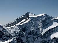
Pioda di Crana it is an important orographic node of the ridge dividing the Toce and Maggia Valley.Important panoramic point of the Val Vigezzo, from Pioda begins an arch of mountains delimiting the valley of torrent Melezzo, Isorno and Onsernone Valley.
The political Italian-Switzerland border designs a deep V between the Piemonte, Lombardia and Tessin Canton, leaving till Splugen Pass the separation between Mediterranian and North Sea. The boder west side is characterised by a long ridge (N to S direction) dividing the Toce Valley (Ossola, Antigorio and Formazza valleys) by the Maggia valley, with several parallel lateral valley branching on the west side (Vigezzo, Onsernone, Vergelletto, Campo and Bosco valleys). At Pizzo Forno, the main ridge is divided into several lateral ridges of mountains that enclose a narrow, far and wild trinagle of valleys with sparse human settlement. (Isorno, Onsernone and Vergelletto valleys).
Pioda di Crana is the main peck of the homonymous sub-group. These mountains are characterised by flanks covered by woods, grasses and bushes, but often with rocky ridge. A typical aspect of such mountains are the so called "piodate" smooth slabs of skewed para-gneiss: the greatest one is on the east side of Pioda di Crana, by which it comes the name.
These mountains offer easy and nice walking on the val Vigezzo Side, whereas the Onsernone side it is characterised by deserted and wild areas.
Pioda di Crana (2430m), Loccia di Peve (2127), Pizzo La Scheggia (2468m), Pizzo Ruggia (2289m), Cima Trubbio (2064m9, Pizzo Formalone (1967m) till Pizzo Ruscada (2004m) are the main mountains of the sub-group.
Arvogno, Santa Maria Maggiore and Toceno offer guest-house: all the mountains can be explored in one-day trip.


Getting There
From Milano (I) drive along the A8 higway direction Varese-Como-Gravellona Toce. Then after Busto Arsizio, follow the A26 "Gravellona Toce-Genova". In Gallarate crossroad of the A8/A8dir-A26: go straight to "Gravellona Toce-Genova-Sempione" direction.Once crossed the Ticino River, follow A26 for Gravellona Toce-Sempione (otherwise you will arrive to Genova). Straight direction Sempione till Domodossola.
From Domodossola take the SS337 direction "Val Vigezzo-Santa Maria Maggiore-Locarno".
From Bellinzona (CH) via Locarno: From Bellinzona follow to Locarno. There is a highway to Locarno. Pass the long tunnel under Locarno downtown you will find indication for "Cento Valli - Onsernone - Maggia". Go ahead and then follow indication for CentoValli. Then you should drive for about 25 km of a narrow but spectacular mountain route till Santa Maria Maggiore.
From Santa Maria Maggiore look for the indication to Toceno and then for Arvogno. The roadway will ends there (limited parking places) and then you can keep walking.
Santa Maria Maggiore it is also a train station of the line Domodossola-Locarno
From Arvogno follow the main road, cross the torrent Melazzo at an iron bridge then the way keep to rise on the flank of the mountains. Follow indication to "Pioda di Crana" and La Colla".
The path rises for about 200 meters between small houses and grasses, then be careful at the board of the beech wood to follow the indication white/red/white. Into the wood the path it is somehow unclear (look for white/red/white or red/yellow marks....a bit confounding) but as a general suggestion just follow the crest of the mountain. Once the wood fade into a larches sparse wood. The just follow the ridge to the top with spectacular views on the "piodate". About 2:30 hours
Red Tape
Be careful for the last 100 meters on the piodata: slippery when wet!Swiss topo 1:50000 N 276 Valle Antigorio
Kompass Cart "Domodossola"
Camping
Camping places in Malesco, Santa Maria Maggiore and in Val Vigezzo.Free camping on the valleys, be carefull in the summer for fire and snakes
Additional information
The mountains betwen Ossola, Maggia and Vigezzo valleys offers several occasion for nice excursion in a wild environment. A neglected corner of leponitne alps, on the trace of the Walser people.A list of few names:
1. Pizzo Quadro and Corona di Groppo (see above)
2. Pizzo Stella
3. Pizzo Lago Gelato
4. Pizzo Medaro or Madei
5. Pizzo Biela
6. Pizzo La Scheggia

Pizzo Quadro (2793m)
Pizzo Quadro it is one of the main mountain of the Maggia-Toce ridge.Located at the end of Valle di Campo, a long and deep lateral valley of valle Maggia. It takes the name by the cubic shape of the top.
From Cevio drive till Cimalmotto (1405m). Left the car in the village (Bus from Locarno till here), follow the path (white/red marks) to Piano della Stufa and then to the Alpe Magnello, a small village (1803). The you have two possible way (the way up it is not very well marked):
1. rise in the valley parallel to the river, and then going to the left side(ascending). At point 2440m (the morrain is more flat there) keep rising on the evident cubic sommital body of the mountains, with a left turning movement. Finally clinb the last 100 meters of the north ridge. Dangerous with snow
2. easier and safer: from Alpe Magnello rising direction North-West look for an evident seddle into the ridge (close to Pioda Baganta 2205). The you cross the south-east ridge of the Pizzo quadro and you gain the large amphiteatre o of Alpe Corona. Then go streight north till cross the west ridge connecting the Pizzo Quadro with Corona di Groppo. Safe and easy.
About 4 hours, path evident just till Alep Magello then....improvvise.
A note: the bottom of the Valle di Campo it is italian, but this smal part of Italy it is easily accesible by Switzerland