La montagna chiama i suoi figli, ed essi rispondono fedelmente al suo appello…
Osvaldo Cardellina, Diario alpinistico, 1964-65
Page texts: @ OsvaldoCardellina"Osva", passed away on May 2, 2022. Page owners: Christian Cardellina e Osvaldo Cardellina. Any updates from September 12, 2022: Antonio Giani, page administrator, friend and climbing companion.
Testi della pagina: @ OsvaldoCardellina "Osva", scomparso il 2 maggio 2022. Proprietari pagina:Christian Cardellina e Osvaldo Cardellina. Eventuali aggiornamenti dal 12 settembre 2022: Antonio Giani, amministratore della pagina, amico e compagno di salite.
Overall Overview
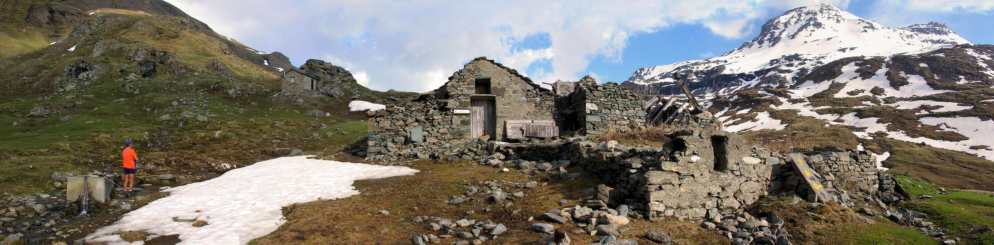
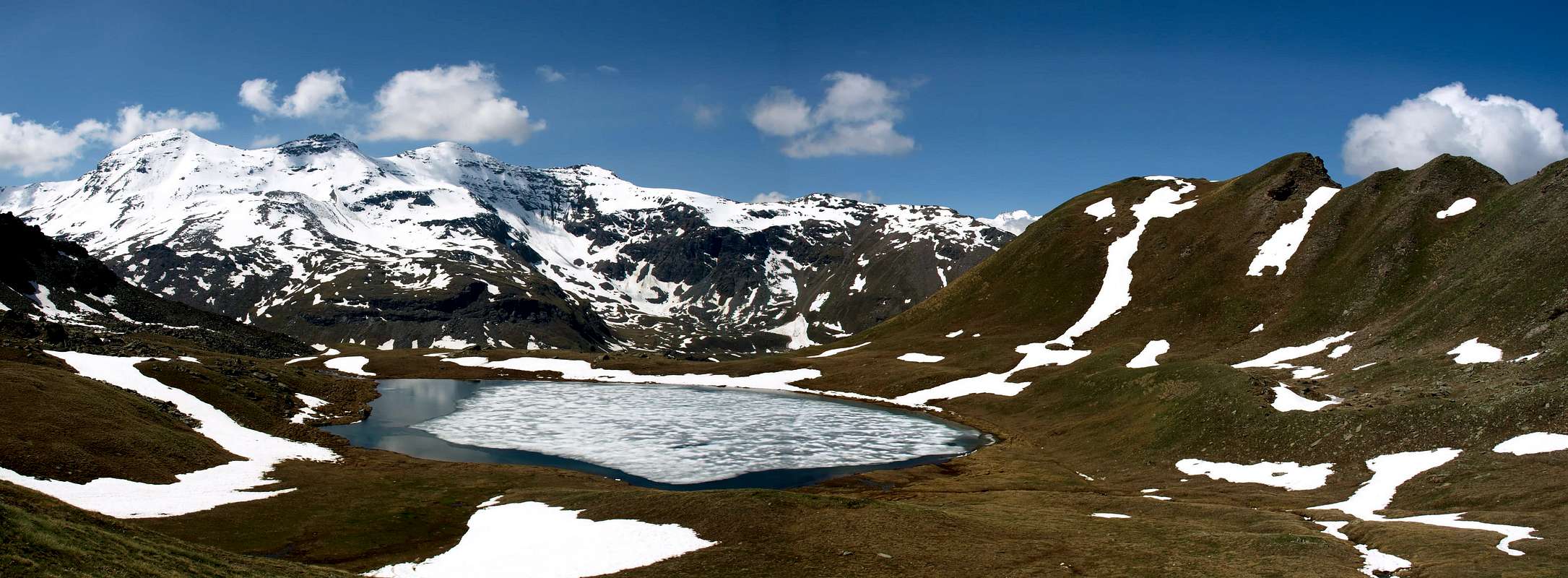
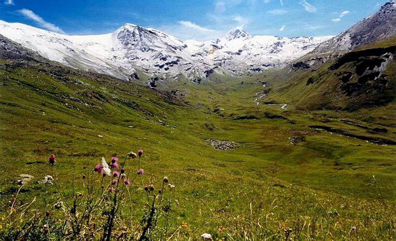
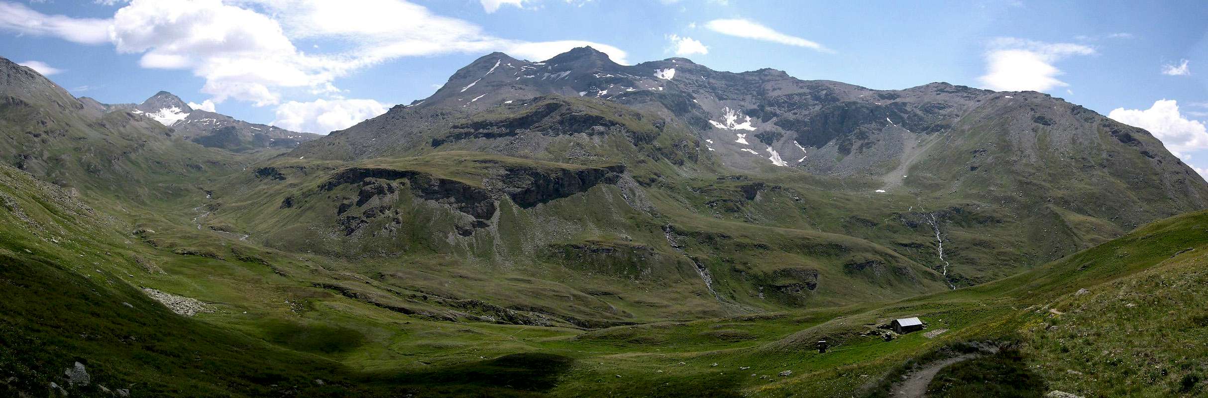
If you search the Top of Ervillères or Erveillère, which is the same thing, you will not find in any book in the world and in any map. But then it does not exist? Of course it physically exists, but it is one of those many elevations and no one knows even less frequent and those that seem to vanish into thin air. As the Point of Dard or Quota 2.033 meters into Group of Mount Emilius, or, better, the Point Leissé or Leysser (2.771m) in one of Mount Fallère that once "discovered" become very fashionable, so much so that on this last now you dispute a famous international race of Ski-mountaineering. Or Points Junod and Garzotto that in the Mountain Chain of Roèses were always rejected by the crossing who did the same. And yet the Court de Bard, a promontory that offers wonderful hike by snowshoes or the famous Becca France July 06th, 1564 day on which they "ate", by a huge and enormous landslide, all of its 600 inhabitants, as he wrote emilius. Many more, which we will present in the future. We'll find a myriad of these elevations "neglected" because they are not fashionable. We, who are "hunters" of these small summits, neglected by climbers, writers, cartographers, and also by hikers because they disregard, instead we go in search of them, if only to get out of the common track, where you putting in a line mass. But this opportunity also occurs on much more famous mountains, which almost always leave some small ridges on their unexplored spire, pinnacle or small tower that can still give room for the imagination, for those who can go to the mountains without being attracted only by the high-sounding names and famous, maybe then as the troop slavishly lined up like sheep or skiers to the ski lift. We, however, that we love the places hidden, unknown and abandoned by God and men, where it passes only the chamois and some solitary hunter behind his footsteps, we are content to these places unusual, almost out of this world. If nothing else from this summit you can grab a bite in absolute tranquility enjoying an less elevated view but "dealt with" by an unusual point of view and with a different angle. You will have fun, also, to make people guess where your pictures were taken. Rarely, if ever, we guessed!... Here you see it emerge as a small rock-cliff on the bottom of the valley down to the left of the vertical in the direction of Penne Blanche Eastern in the first picture and centrally between the two Penne in the second pano.
Se cercate la Punta di Ervillères o Erveillère, ch'é la medesima cosa, non la troverete in alcun libro al mondo e in nessuna carta topografica. Ma allora non esiste? Certo che fisicamente esiste, ma é una di quelle tante elevazioni che nessuno conosce ed ancora di meno frequenta e tali che sembran svanire nel nulla. Come la Punta del Dard o Quota 2.033 metri nel Gruppo del Monte Emilius, o, e meglio, la Punta Leissé o Leysser (2.771 m) in quello del Mont Fallère che una volta "scoperte" diventan di grande moda, tanto che su quest'ultima adesso si disputa una famosa gara internazionale di Sci-alpinismo. Oppure le Punte Junod e Garzotto che nella Catena delle Roèses venivan sempre scartate da chi compiva la traversata della stessa. Ed ancora alla Court de Bard, splendido promontorio che offre splendida escursione con racchette da neve od alla celebre Becca France che il 6 di Luglio 1564 si "inghiottì", con una frana enorme ed immane, tutti i suoi 600 abitanti, come ha scritto emilius. E tante altre ancora, che vi presenteremo in futuro. Scopriremo una miriade di queste elevazioni "trascurate", perché non fanno moda. Noi, che siam "cacciatori" di queste piccole sommità, trascurate da alpinisti, scrittori, cartografi ed anche dagli escursionisti perché le misconoscono, invece andiam alla loro ricerca, se non altro per uscire fuori dai comuni binari, ove si intruppa la massa. Ma quest'opportunità si verifica anche su montagne ben più famose, che lasciano quasi sempre sulle loro creste qualche piccola guglia, pinnacolo o torrioncino inesplorato che può ancora dare spazio alla fantasia, per chi sa andare in montagna senza farsi attrarre solamente dai nomi altisonanti e famosi, magari poi incolonnandosi pedestremente in fila come le pecore o gli sciatori allo skilift. Noi invece che amiamo i luoghi reconditi, sconosciuti ed abbandonati da Dio e dagli uomini, dove passa solo il camoscio e qualche solitario cacciatore dietro le sue orme, noi ci accontentiamo di questi luoghi inusuali e quasi fuori dal mondo. Se non altro da queste neglette sommità potrete mangiare un boccone in assoluta tranquillità godendo di un panorama meno elevato ma "affrontato" da un punto di vista insolito e con una diversa angolazione. Vi divertirete, inoltre, a far indovinare da dove sian state prese le vostre fotografie. Raramente, anzi mai, ci azzeccano!... Qui la vedete emergere a mò di scoglio sul fondo valle scendendo sulla sinistra della verticale in direzione del Penne Blanche Orientale nella prima foto e centralmente in mezzo ai due Penne nella seconda panoramica.
Specific Overview
This little summit that, in spite of a relatively high proportion of nearly 2.800 meters, it is "dispersed" at the foot of the Northern Mount Penne Blanche (3.248m) does not have a name as well as its placement is not easy if you do not know the the area. Do not named on the books and maps we find the first record of its existence in the Paper Enrico, Edit. in Ivrea-Aosta 1:50.000, where the altitude is assigned fairly accurate 2.790 meters, but she is not given any name. More precise instead the Map trails 10, Edit. L'Escursionista, "Cogne Valley" that the 2.799 meters altitude. Lying on the perpendicular line joining the intersection between the two Penne Blanche/Torrents Doreire and Ervillères and immediately to the East-southeast of this latest Alps (2.515m), we propose the name of Point Ervillères of the newly named below is alpage. Formed by a large grassy back-debris at the edge of the Eastern Plan of Paravére, surrounded at the Northern base by a short rock wall that goes out on a slope of blocks broken, immediately to the East of a rocky band, which stretches from West to East and placed inside two small vallons which run in three little torrents. Dominated by the masses in the South "bullies" of the two Penne Blanche Western and Eastern), in turn dominates the four Lakes Doreire underlying Pass of Invergneux (2.902m), between the Walloons of the Grauson-Doreire/Urtier, the last in Cogne Valley. Nice outing for early and late season can be accomplished with a circular tour, starting from the Alps New Grauson or Lower (2.273m), rises to the Lake of Money (2.550m), into homonymous narrow basin, crosses to the East the Puy de Va(e) rdettaz (2.574m), dates back to Lake of Testa also called Tz'te by the inhabitants (2.753m) and then reach the top again with a long crossing to the East over the Plan de Paravére. The descent allows the opportunities to go directly to the valley or to extend most of the crossing, reaching four lakes and, optionally, the Pass of Invergneux also Hevergnes (Winter Houses in old times). In any case the return to Gimillan Hamlet must take place along the Vallon of Grauson, Doreire branch, passing through the Alps Ervillères and Pralognan (2.416m) and closing the circle to Grauson Vieux. Excursion along the path but easy, allowing you to visit places such as wild untouched; can be a good hike early in the season, but also the end of the first arrival of heavy snowfall. In any case, it is also possible by around snowshoes, taking the precaution, however, to check out these two sectors:
a) - at the bottom of the entrance in the forest above Pila Pasture, after that of Ecloseur, until arrival at Old Grauson, in the case that the slopes to cross are formed by too much snow and hard work involving a 35° and over jumps and are exposed to on the underlying Torrent de Grauson, up to a hundred meters high. Requires technique and experience with snow rackets, gear is not always easy to administer in particular situations, where it becomes very dangerous, also the final stretch between Alp Créuzet also Cròuzet to the Cross on the headland before Grauson is exposed to avalanche from the slopes of Mount Creya.
b) - Examine the condition of the snow in the long traverse between Lake of Money and the Verdetta Promontory and in any case far away as possible from the overlying rocky slopes, between the North Buttress of Pointe Coupée (3.211m) and the same. Either way tucking better to give up on a lap down, into Grauson Walloon, that from Pila Pasture returns on the other side of the torrent towards Tzécheu or Tchecheu Pasture and the wooden promontory above that of Ecloseur (Narrow Closure of walloon), whence, again with the path n° 8, return to Gimillan Hamlet. Splendid views of the Groups Garin, Emilius and Tersiva that, in a circular manner, frontally stand out from West to East; beautiful quick glances on the above Subgroup of Penne Blanche that, from the Invergneux Hill to Mount Creya (3.015m), serves as the watershed with Urtier Vallon.
Questa piccola sommità che, a dispetto d'una quota abbastanza elevata di quasi 2.800 metri, risulta "dispersa" alle pendici Settentrionali del Mont Penne Blanche (3.248 m) non possiede un nome ed anche il suo collocamento non é semplice se non si conosce bene la zona. Non nominata sui libri e sulle cartine troviam la prima segnalazione della sua esistenza nella Carta Enrico, Edita ad Ivrea-Aosta 1:50.000, dove le viene assegnata un'altitudine abbastanza precisa di 2.790 metri, ma non le viene attribuito alcun nome. Ancora più precisa invece la Carta dei sentieri 10 dell'Escursionista "Valle di Cogne" che la quota 2.799 metri. Trovandosi sulla linea perpendicolare che unisce il Penne Blanche all'incrocio tra i due Torrenti Doreire e di Ervillères e subito ad Est-sudest di questa ultima Alpe (2.515 m), proponiamo il toponimo di Punta di Ervillères dal nome dell'appena sottostante alpeggio. Trattasi d'un grosso dosso erboso-detritico al margine Orientale del Pian di Paravére, cinto alla base Settentrionale da una paretina rocciosa che si spegne su di un pendio di blocchi frantumati subito ad Est di una fascia rocciosa, dispiegantesi da Ovest ad Est nonché collocata all'interno di due piccoli valloni nei quali scorrono tre torrentelli. Dominata a Mezzogiorno dalle masse "prepotenti" dei due Penne Blanche, domina a sua volta i quattro Laghi Doreire sottostanti al Pas d'Invergneux (2.902 m), tra i Valloni del Grauson-Doreire e quello dell'Urtier in Valle di Cogne. Gita piacevole d'inizio e fine stagione può essere compiuta con un giro circolare che, partendo dall'Alpe Grauson Nuove o di Sotto (2.273 m), sale al Lago di Money (2.550 m), nell'omonimo ristretto bacino, attraversa verso Est il Puy de Va(e)rdettaz (2.574 m), risale al Lago di Testa o, per i locali, di Tz'te (2.753 m) per poi raggiungere la cima ancora con lunga traversata ad Est sopra il Plan de Paravére. La discesa consente le opportunità di calare direttamente verso il fondovalle oppure di allargare maggiormente il tour raggiungendo i quattro laghi e, volendo, lo stesso Passo d'Invergneux o des Hevergnes (abitato anche negli inverni in tempi più remoti). In ogni caso il rientro a Gimillan deve avvenire lungo il Vallone di Grauson, ramo di Doreire, passando per le Alpi di Ervillères e Pralognan (2.416 m) e chiudendo il cerchio al Grauson Vieux. Gita di lungo percorso ma facile, consente la visita di luoghi tanto selvaggi quanto incontaminati; può costituire una buona escursione di inizio stagione, ma anche di fine prima dell'arrivo di abbondanti nevicate. In ogni caso risulta giro effettuabile anche con le racchette da neve, avendo però la precauzione di controllare questi due settori:
a) - nella parte bassa dall'ingresso nel bosco sopra l'Alpe Pila, dopo quella di Ecloseur, fino all'arrivo al Grauson Vieux; nel caso che i pendii da attraversare siano formati da gonfie con troppa neve e dura comportano un lavoro a 35° ed oltre e sono esposti a salti sul sottostante Torrent de Grauson, alti fino a cento metri. Richiedono tecnica ed esperienza con le racchette da neve, attrezzo non sempre facile da amministrare in particolari situazioni, ove diventa anche molto pericoloso; inoltre il tratto finale tra l'Alpe Créuzet o Cròuzet fino alla Croce sul promontorio prima di Grauson é esposto a valanga dalle pendici del Monte Creya.
b) - Esaminare lo stato della neve nella lunga traversata tra il Lago di Money ed il Poggio di Verdetta ed in ogni caso allontanarsi il più possibile dai soprastanti pendii rocciosi, tra il Contrafforte Settentrionale della Pointe Coupée (3.211 m) ed il medesimo. In entrambi i casi conviene rinunciare ripiegando su di un tour più in basso, interno al Vallone del Grauson, che dall'Alpe Pila ritorna sull'altra sponda del torrente verso l'Alpe di Tzécheu o Tchecheu ed il promontorio boschivo sopra quella dell'Ecloseur (La Chiusura), donde, sempre con il sentiero n° 8, rientrare a Gimillan. Splendide viste sui Gruppi di Garin, Emilius e Tersiva che, in modo circolare, si staglian frontalmente dall'Ovest all'Est; bei colpi d'occhio sul soprastante Sottogruppo del Penne Blanche che, dal Pas d'Invergneux fino al Mont Creya (3.015 m), funge da spartiacque con il Vallone dell'Urtier.
Getting There
BY CAR:
From Torino, Milano, etc: Motorway A5. Exit in Aosta Ovest. Drive to the near Aymavilles. Follow in the direction of Valle di Cogne.
From Switzerland: through the Grand St. Bernard Tunnel or the homonym Pass). Drive to Aosta, then follow Courmayeur direction on SS.26. Just after Sarre, turn to the left, in the direction of Valle di Cogne.
From France: through Mont Blanc Tunnel or Petit St. Bernard Pass). It isn't necessary to enter in Motorway A5, you can drive through SS.26 Aosta direction. Before arriving at the Village of Sarre, follow the sign and turn right towards Valle di Cogne.
BY PLANE:
Aeroporto "Corrado Gex" Saint Christophe (Aosta).
Specific Itinerary Road:
After Aymavilles, the SR.47 crosses the Hamlets of Vieyes, Epinel and Cretaz and after about 25 Km. arrives at Cogne (1.534m).Follow the road signs, with East direction, for Gimillan and Lillaz. Arrived at a round-about, recently built in proximity of the St. Anthony Chapel, leaving East the main road towards Lillaz Hamlet (7,500 Km.) go left along the scenic route leading to the Village of Montroz and the Hamlet of Gimillanor Dzèmi(e)llan(1.787m), 3 Km. after Cogne. Usually no parking problem, either in the center of the village in the parking lot at the church as the road next to the Dzèmillan Torrent, as well highlights the photos (better).
Approach
From the bridge just to the West of Gimillan (1.814m; small parking lot), take the private road that climbs towards the Northeast, leaving on the right the little village of Tarrabouc (1.831m; small chapel, closed), take the path n° 8, surpassed the Ràvènti (1.895m; ruins) reaches a small votive chapel, with a diagonal dominating the Torrent de Lussert, and a short descent to reach the Alpe di Tchezen near the small wooden bridge and the old Alp of L'Ecloseur (1.903m; The Narrowing; 0h'35). A long diagonal in the middle of meadows, destroyed by the 2000 and then restored, leads to Pila Pasture (2.021m; beautiful waterfall ruined by the recent overbuilding), past the rocky promontory above ( propped up wooden steps to the iron base) you enter a small walloon that goes with hairpin bends. The highest plateau leads to a first junction to the isolated Alp Cròuzet (2.244m) and, soon after, a subsequent in Southeast where the salt route n° 8C to Mount Creya (3.015m); abandon both diversions and instead continue with the same in a small wood. The long diagonal with over 100 meters of elevation gain over the Torrent de Lussert reaches a cross on the lawn at the next headland and the Grauson Vieux Pastures (2.273m; just South spring called Prà Veudan; 1h'05/in total 1h'40/5) .
Dal ponte appena ad Ovest di Gimillan (1.814 m; piccolo parcheggio) prendere la strada poderale che sale verso Nordest; lasciando a destra il piccolo Villaggio di Tarrabouc (1.831 m; piccola Cappella, chiusa) proseguire con il sentiero n° 8 che, sorpassato il Ràvènti (1.895 m; rovine) raggiunge una piccola cappella votiva; con un diagonale, dominando il Torrent de Lussert, ed una breve discesa raggiungere l'Alpe di Tchezen il vicino piccolo ponte in legno e la vecchia Alpe di Ecloseur (1.903 m; La Strettoia; 0h'35). Un lungo diagonale in mezzo ai prati, distrutti dall'alluvione del 2000 e poi ristrutturati, conduce all'Alpe Pila (2.021 m; bella cascata rovinata dalle recenti cementificazioni); superando il soprastante promontorio roccioso (gradini in legno puntellati alla base in ferro) si entra in un piccolo vallone che si risale con stretti tornanti. Il pianoro superiore conduce ad un primo bivio per l'isolata Alpe Cròuzet (2.244m) e, subito dopo, ad un successivo dove a Sudest sale il sentiero n° 8C per il Monte Creya (3.015 m); abbandonare entrambe le deviazioni e proseguire invece con la stessa in un piccolo bosco. Il lungo diagonale con oltre 100 metri di dislivello sopra il Torrent de Lussert raggiunge una croce sul promontorio ed il successivo prato presso l'Alpe di Grauson Vieux (2.273 m; appena a Sud sorgente detta di Prà Veudan; 1h'05; 1h'40/5).
Route
There are two ways with which to begin the Way
1) - Just before you reach the Alp of Grauson New Cross from 2.296 meters to take the path-route n° 8C with the direction that leads in Southeast to Lake of Money (2.550m; 0h'35) and after a diagonal pass the same under some rock bands and with a final stretch, crossed by brooks effluent reaches the Northern shore and the subsequent plateau.
2) - Continue (better) with the path n° 8 until near the Alp Grauson Vieux (2.273m). Before the small bridge that leads to this, and just south of a spring called Prà Veudan starts a shortcut to the path n° 8C reaching towards South Lake Money. From the lake to move towards the Northeast, and passing under a series of high rock walls, reached by a small path and then traces the Poggio Vardetta or Verdetta (2.574m), from this direction with the Southeast and then continue along the Torrent de Tz'te that comes from the lake. Go up this small valley on the grassy slopes (in the end of season snowfields quite steep), debris and blocks until you reach the same (2.753m), from this cross to the East-southeast, with the same type of path and bypassing the two altitudes in the South 2.783m, 2.789 meters (* possibility to climb higher to reach the two subsequent 2.917m, 2.969 meters through steep moraine at the base of the remains of an ancient glacier at the foot of Western Penne Blanche), the Plan of Paravère at the base Northern Summit of the two Penne Blanche (West 3.205m, 3.248m East) coming to the Southwest Quota 2.799 meters or Point of Ervillères. With a short and easy climb over rocks and broken blocks, in early season snow fields of average steepness, attain Summit, on which has been erected a small stone cairn (1h'00; 3h'30/4h'00 by Gimillan).
Esistono due possibilità con le quali iniziare la Via
1) - Appena prima di raggiungere l'Alpe di Grauson Nuove dalla Croce 2.296 metri prendere il sentiero n° 8C che con direzione Sudest porta al Lago di Money (2.550 m; 0h'35); dopo un diagonale lo stesso passa al di sotto di alcune fasce rocciose e con un ultimo tratto, attraversato dai rigagnoli dell'emissario, raggiunge la sponda Settentrionale e la successiva spianata.
2) - Continuare (meglio) con il sentiero n° 8 fino nei pressi dell'Alpe di Grauson Vieux (2.273 m). Prima del piccolo ponte che porta a questa ed appena a Sud di una sorgente detta di Prà Veudan inizia una scorciatoia verso il sentiero n° 8C che raggiunge verso Sud il Lago di Money. Dal lago indirizzarsi verso Nordest e, passando al di sotto di una serie di alte fasce rocciose, raggiungere con un piccolo sentiero ed in seguito delle tracce il Poggio Vardetta o Verdetta (2.574 m); da questo con direzione Est e poi Sud proseguire lungo il Torrent de Tz'te che proviene dal lago omonimo. Risalire questo valloncello su pendii erbosi (in fine stagione nevai abbastanza ripidi), detriti e blocchi fino a raggiungere il medesimo (2.753 m); da questo attraversare verso Est-sudest, con lo stesso tipo di percorso ed aggirando a Sud le due quote 2.783 e 2.789 metri (* possibilità di salire più in alto raggiungendo le successive di 2.917 e 2.969 metri lungo ripida morena alla base dei resti di un antico ghiacciaio ai piedi del Penne Blanche Ovest), il Pian di Paravère posto alla base Settentrionale delle due Sommità del Penne Blanche (Ovest 3.205 m, Est 3.248 m) arrivando a Sudovest della Quota 2.799 metri o Punta di Ervillères. Con una breve e facile salita su rocce rotte e blocchi, in inizio di stagione nevai di media ripidità, raggiungere la Sommità, sulla quale é stato eretto un piccolo tumulo in pietra (1h'00; 3h'30/4h'00 da Gimillan).
Descent
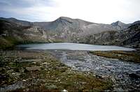
From the top down for easy grassy slopes to the East, or through large snowfields of modest incline, reaching two tiny frozen lakes (the latter with the incredibly surface downhill!) and from these directly to the North along a small torrent in a walloon that reaches, with scarce traces, debris and scattered blocks in grassy slopes, the Torrent Doreire on the bottom of the valley floor at about 750 meters to the East-southeast from the Ervillères Pasture.
Forded the same at an altitude about 2.620 meters take the path n° 8/TVC that leads to the Pas of Invergneux and with that you come first Alp of Ervillères, with parallel way and just above the Torrent that from this point takes the name of Grauson, and later that of Pralognan (2.416m). From this, still further West you reach the junction approximately 2.400 meters (various signs; to the North path 8A to the Lakes Lussert or to Corona's Lake and Hill) and the next Pikaciù Bridge (2.298m), in the triple Torrents meeting of the Corona, Grauson and of Money, from this quickly you get to Grauson Vieux Pastures, whence by the same route to the small bridge nearby Hamlet of Gimillan.
Dalla Sommità scendere per facili pendii erbosi, oppure attraversando ampli nevati di modesta pendenza, verso Est raggiungendo due minuscoli laghi ghiacciati (il secondo incredibilmente con la superficie in discesa!) e da questi direttamente a Nord lungo un torrentello dentro una valletta raggiungendo, con percorso di scarse tracce tra pendii erbosi, detriti e blocchi sparsi, il Torrent Doreire sul fondo valle a circa 750 metri ad Est-sudest dall'Alpe d'Ervillères.
Guadato il medesimo a quota 2.620 metri circa si prende il sentiero n° 8/TVC che porta al Pas d'Invergneux e con questo si raggiungono dapprima l'Alpe di Ervillères, con percorso parallelo ed appena al di sopra del Torrent che da questo punto prende il nome di Grauson, ed in seguito quella di Pralognan (2.416 m). Da questa, sempre con percorso verso Ovest, si raggiunge il bivio 2.400 metri circa (panneaux varii; verso Nord sentiero 8A per i Laghi di Lussert oppure verso Lago e Colle Coron's) ed il successivo Ponte di Pikaciù (2.298 m), al triplice incontro dei Torrenti Corona, Grauson e di Money; da questo rapidamente si arriva al Grauson Vieux, donde tramite la via di salita al ponte presso al Villaggio di Gimillan.
Difficulty & Equipment
EE; for Hiking.
EE; da Escursionismo.
Campings
Remember that free camping is forbidden (except for emergency reasons, over 2.500m, from darkness until dawn).
Mountain Conditions
You can get meteo information at the official site of the Regione Valle d'Aosta:
Parents refers to a larger category under which an object falls. For example, theAconcagua mountain page has the 'Aconcagua Group' and the 'Seven Summits' asparents and is a parent itself to many routes, photos, and Trip Reports.


 7116 Hits
 82.62% Score
 16 Votes