La montagna chiama i suoi figli, ed essi rispondono fedelmente al suo appello…
Osvaldo Cardellina, Diario alpinistico, 1964-65
Page texts: @ OsvaldoCardellina"Osva", passed away on May 2, 2022. Page owners: Christian Cardellina e Osvaldo Cardellina. Any updates from September 12, 2022: Antonio Giani, page administrator, friend and climbing companion.
Testi della pagina: @ OsvaldoCardellina "Osva", scomparso il 2 maggio 2022. Proprietari pagina:Christian Cardellina e Osvaldo Cardellina. Eventuali aggiornamenti dal 12 settembre 2022: Antonio Giani, amministratore della pagina, amico e compagno di salite.
Overview
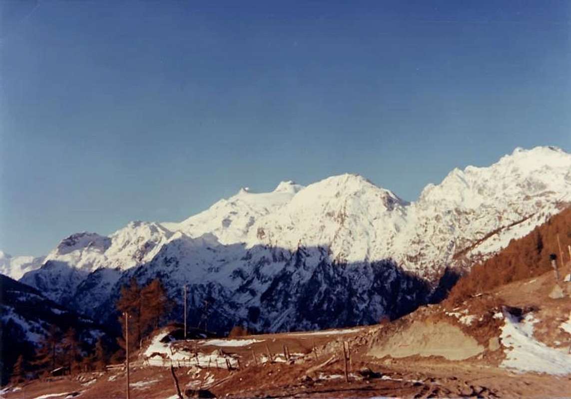
"I am beginning to grow Old ... Mom, what fatigue! / Comincio invecchiar ... Mamma, che Fatica!", by emilius
We continue to research and the dissemination of those tips unknown to almost everyone, certainly not famous and surely even less popular. Some are not even, if not in topographic relief, shown on the Maps, including those from the minute detail. Often they are also daughters of anyone, because they do not even have a name and you give it to them, taking into account the local toponymy revolt, at least, in the hills, locations identified in time by pastors or to the surrounding pastures and alps. By contrast Summit offer these corners of nature still somewhat intact and are definitely "islands of peace", where they held mass it looks good. Even so, at times, are not so easy to climb and did not address them in full season but maybe in the Spring or Autumn, when the snows of winter still remain, or get past the first snowfall of the next, it has not always easy and even banal. Do not look for the glory of these mountains, because there is nothing there, but, certainly, you will discover new places which give rise to new and unusual views.
Continuiamo nella ricerca e nella divulgazione di quelle punte sconosciute quasi a tutti, non certo famose e sicuramente ancor meno frequentate. Alcune non son neppure, se non nel rilievo topografico, rappresentate sulle Carte Geografiche, anche in quelle dal dettaglio minuzioso. Spesso son anche figlie di nessuno, poiché non hanno neppur un nome e bisogna darlo loro tenendo in considerazione la toponomastica locale rivolta, almeno, a colli, località individuate nel tempo dai Pastori oppure ad alpeggi e pascoli dei dintorni. Per contro queste Sommità offrono angoli di natura ancora integerrima e sono sicuramente "isole di pace", ove la massa si guarda bene d'approdarvi. Anche perché, a volte, non sono di salita così semplice ed il fatto d'affrontarle non in piena stagione ma magari in Primavera oppur in Autunno, quando permangono ancora le nevi dell'Inverno passato oppure van arrivando le prime nevicate del successivo, non sempre si presenta facile e neppur banale. Non cercate gloria su queste montagne, ché non ne trovate, ma, certamente, scoprirete luoghi nuovi che dan adito a vedute nuove ed inusuali.
The Summit of Faveroy, so the name is from the underlying Alp (2.039m) located in the Walloon of the same name now to the Northwest and the nearby Hill of Faveroy (2.245m) in the Southwestern Top of the same (2.254m, GPS) and the Torre Tonda (Round Tower; 2.583m) on the crest of that, starting from Monte Colombo (1.854m) dates back to the Southwest, ending with the magnificent pyramid of Mount Paramont (3.300m), is located along the watershed between that part of the valleys of La Thuile from the high walloons of the Dora Baltea projected onto the Central Valley. It comes after the squat-wooded promontory of Monte Colombo rocky projected above the Hamlets of Runaz and Rochefort-la Ravoire, like a big hump wooded with sinuous, dates back more slender towards the Top of the Northeast (2.234m, GPS) and later to the Southwest, the highest (2.254m), with a few drops metres in altitude to the homonymous hill, over the ridge rises again, more imposing, to the Tonda Tower and then go more towards the West, in the direction of the Tower of Tighet or Tignet, Bec Taillà and Point of Crosatie. From this point the watershed, after forming the Hill of Mollette (2.774m) is directed more towards the Southwest, and climbed the Mount Pit, ends with its long Ridge Northeast of Paramont. From this point stretches the great divide between the "Valgrisenza" to the East and the Valley of La Thuile true to the Top of the Head Rutor (3.486m). A long "speech", where the Tops are Faveroy the hall and antechamber where you will find only a few Poacher or some Hunter of wild boars. But only in parts "low", since where, starting from Monte Colombo, the ridge becomes more aerial and rocky you will find only the most wild boars. Do not armed, of course ... Going up, you will find many animals that flee upward looking for the salvation of rocky cliffs. Coming down, You will meet men armed with weapons of war and telescopes. Angry, because you did escape the prey, where they do not have the courage to go!
La Punta di Faveroy, così la chiamo dal sottostante Alpeggio (2.039 m) posto nel Vallone omonimo subito a Nordovest e dal vicino Colle di Faveroy (2.245 m) tra la Punta Sudovest delle medesime (2.254 m, GPS e la Torre Tonda (2.583 m) sulla cresta che, partendo dal Monte Colombo (1.854 m) risale verso Sudovest, concludendosi con la magnifica piramide del Mont Paramont (3.300 m), é situata tra questo lungo spartiacque divisorio le Valli di La Thuile dagli alti valloni proiettati sulla Valle Centrale della Dora Baltea. Si presenta, dopo il tozzo promontorio boschivo-roccioso del Monte Colombo proiettato al di sopra degli abitati di Runaz e Rochefort-la Ravoire, come un grande dosso boscoso che, con andamento sinuoso, risale più snello verso la Sommità Nordest (2.234 m, GPS e dopo verso la Sudovest, la più elevata (2.254 m), scende con pochi metri di dislivello all'omonimo colle; oltre la cresta si rialza, più imponente, verso la Torre Tonda per poi proseguire, più verso Ovest, in direzione della Torre del Tighet o Tignet, del Bec Taillà e della Punta della Crosatie. Da questo punto lo spartiacque, dopo aver formato il Colle delle Mollette (2.774 m) si indirizza maggiormente verso Sudovest e, scavalcato il Mont Pit, si conclude con la sua lunga Cresta Nordest al Paramont. Da questo punto si allunga il grande spartiacque tra la "Valgrisenza" ad Est e la Valle di La Thuile vera e propria insino alla Sommità della Testa del Rutor (3.486 m). Un lungo "discorso", dove le Punte di Faveroy costituiscono l'anticamera dell'anticamera e dove troverete soltanto qualche Bracconiere o qualche Cacciatore di cinghiali. Ma sol nelle parti "basse", poiché dove, partendo dal Monte Colombo, la cresta diventa più aerea e rocciosa incontrerete soltanto più che i cinghiali. Non armati, logicamente ... Salendo, troverete molti animali che sfuggon verso l'alto cercando la salvezza su strapiombi rocciosi. Scendendo, incontrete uomini armati con armi da guerra e cannocchiali. Inferociti, perché gli avete fatto scappare la preda, ove lor non han coraggio d'andar!
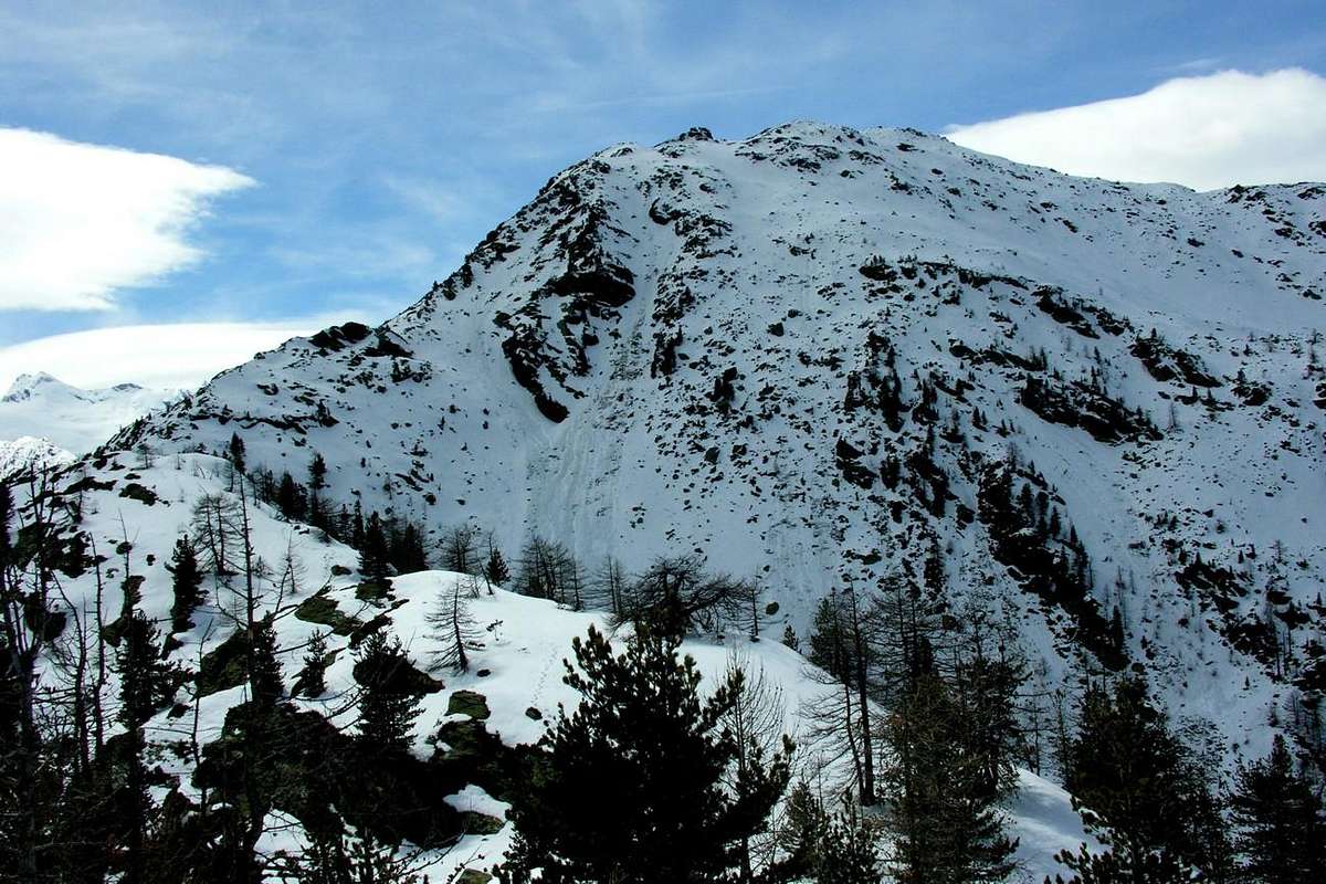
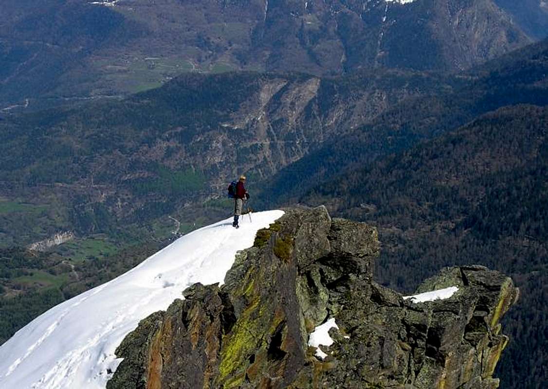
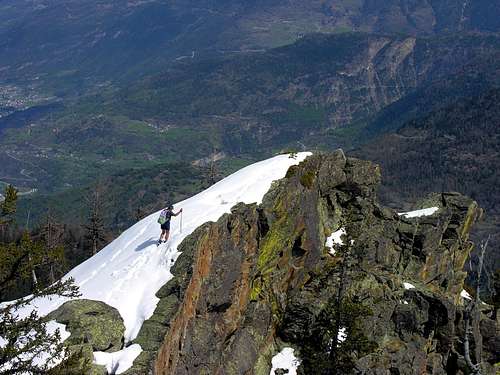
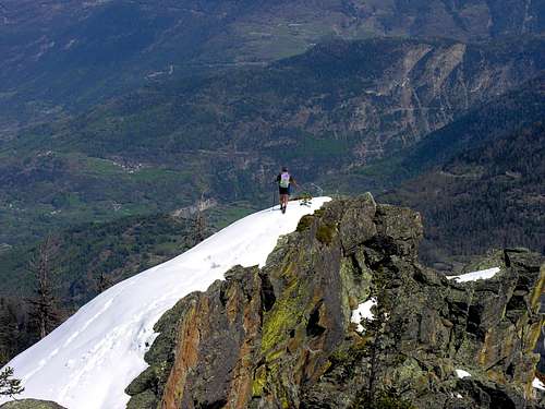
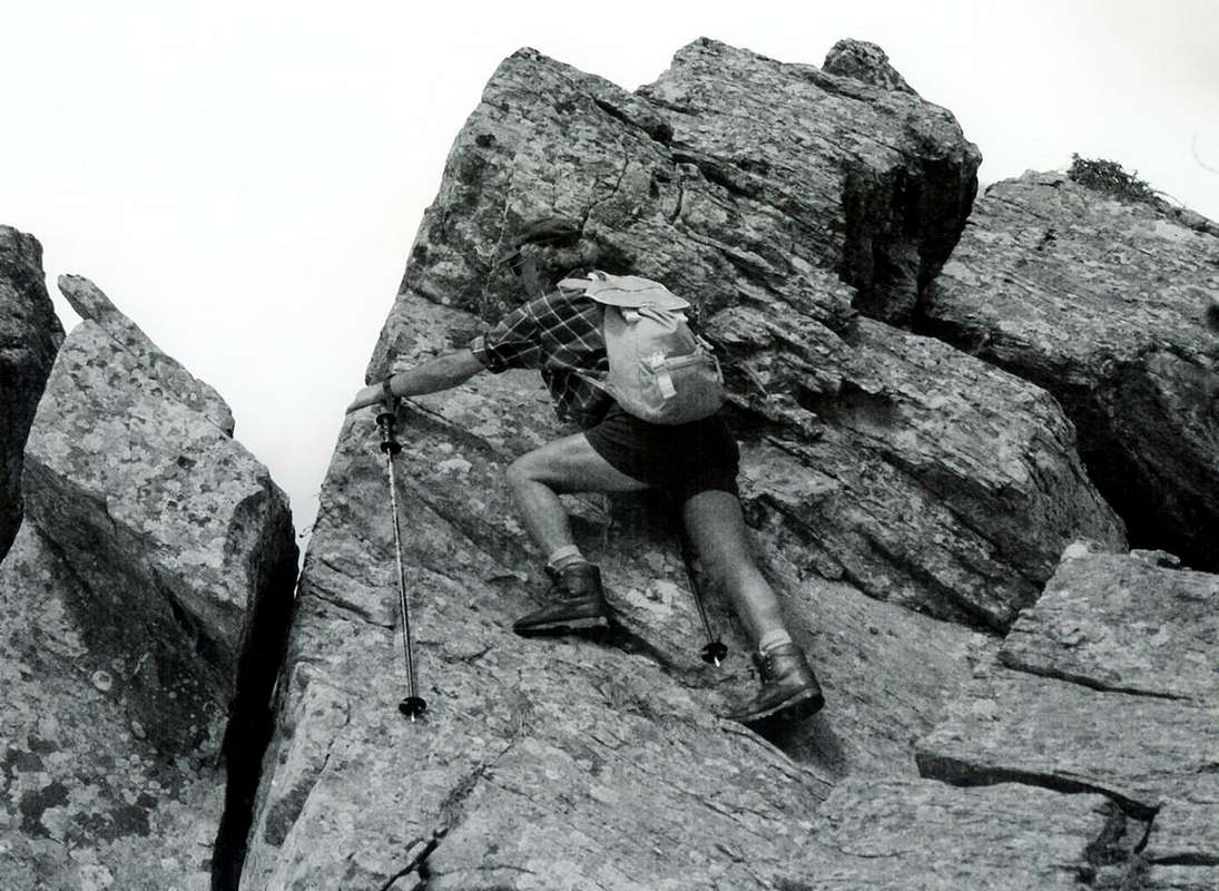
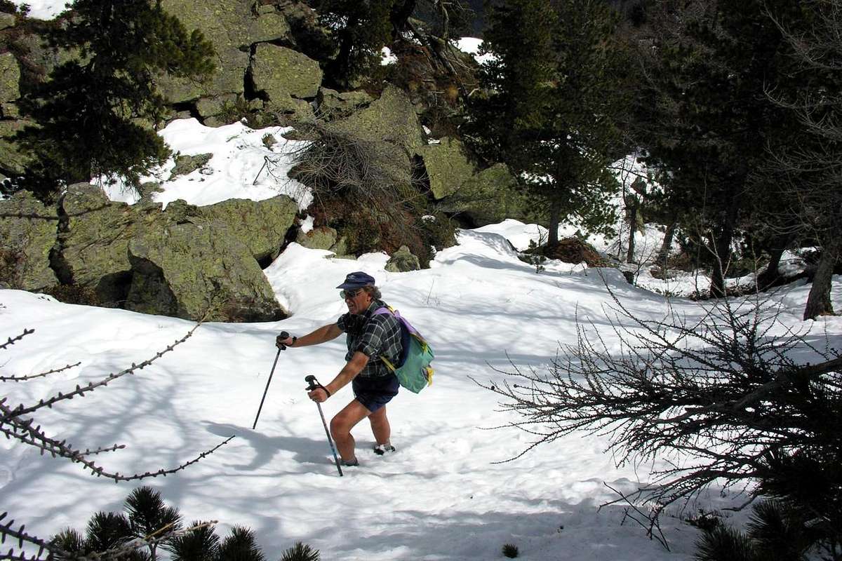
The two Summits of Faveroy you see in the two photos by Emilius, without being mentioned in the first in the respective captions. They are to be placed, as can easily be seen in the lower part, just below the Tower Tonda and over the Mount Colombo. Emilio had not even mentioned if not only fleetingly, yet he climbs April 28th, 2005, departing from the Village of Baulen or Baulin (1.775m), through the via to Hill of Mount Colombo.
Le due Punte di Faveroy le vedete nelle due foto di emilius, senza essere menzionate nella prima nelle rispettive didascalie. Son da collocare, come facilmente se ne evince, nella parte bassa, appena sotto la Torre Tonda e sopra il Monte Colombo. Neppure Emilio l'aveva citate se non di sfuggita, eppur le aveva salite il 28 Aprile 2005, con partenza dal Villaggio di Baulen o Baulin (1.775 m), tramite la via che passa al Colle del Monte Colombo.
Getting There & Road Itinerary
BY CAR:
From Torino, Milano, etc: Motorway A5. Exit at Aosta Ovest.
From Switzerland: through the Grand Saint Bernard Tunnel or the namesake Pass. •From France, through the Mont Blanc Tunnel or Petit Saint Bernard Pass: It is not necessary to take Motorway A5: you can drive on SS.26, in the direction of Leverogne.
BY PLANE:
Aeroporto "Corrado Gex" Saint Christophe (Aosta).
Road Itinerary From Aosta Town (583m) follow SS.26 toward Mount Blanc. Once close to the Village of Leverogne (780m), turn left on the Regional Route for Valgrisenche. Pass many small Villages, including Rochefort, La Ravoire and, after some 10 km turn to the right toward Planaval (1.580m). Planaval to go back to the North with Municipal Road to La Clousaz Hamlet (1.608m) and the next Village of Baulen (1.775m), placed in an esplanade overlooking the Grisenche Valley and beautiful quick glances on the City of Aosta.
Dalla Città di Aosta (583 m) si percorre la SS.26 per il Monte Bianco e, giunti nei pressi dell'abitato di Leverogne (780 m), si imbocca sulla sinistra la strada regionale per la Valgrisenche. Dopo aver superato le Frazioni di Rochefort, La Ravoire, e percorso una decina di chilometri svoltare a destra verso la Frazione di Planaval (1.580 m). Da Planaval risalire verso Nord con la Strada Comunale per La Clousaz (1.608 m) ed il successivo Villaggio di Baulen (1.775 m), posto in una amena spianata con bella vista sulla Grisenche e sulla Città di Aosta.
Route
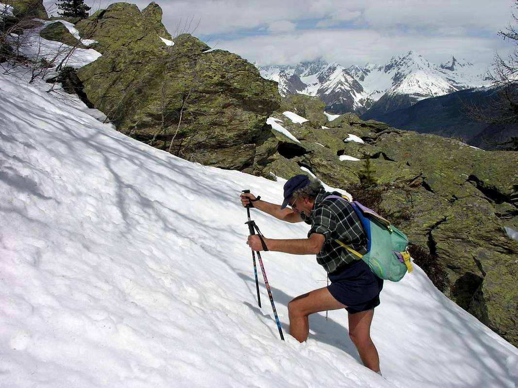
From the Village of Baulen or Baulin (signals; small parking lot amongst the houses) take the path, reported but not numbered, that is directed before for a short distance to the Northwest and after to the Northeast, and then, passing high above the Alp Milliery (1.656m) and with some ups and downs surrounded by spectacular large boulders and fallen logs, not without some difficulty cumbersome, despite the signs, reach the small collar immediately to the West of Mount Colombo, near a clearing. In a short time without any difficulty and you can reach this Summit (1.854m). After returning to the hill, continue to follow the watershed to the West and, after some short rocky fun not difficult, and probably avoidable in the absence of snow, get some colored rocks that fall with sulfur cliffs towards Southeast. In a short time you will reach the Northeast Summit (2.234m, GPS), where the ridge changes direction in the Southwest. Through a shorter crossing between blocks scattered, difficult with snow, we reach the Summit Southwest (2.254m, GPS), above of a few metres the hill of the same name (1h'30/2h'00 from Baulen Village).
In descent: same route.
On Northeast Crest of Faveroy Northeastern Summit (about 2.220 meters)
Dal Villaggio di Baulen or Baulin (segnaletica; piccolo parcheggio tra le baite) prendere il sentiero, segnalato ma senza alcuna numerazione, che si indirizza per breve tratto a Nordovest e poi a Nordest e, passando alto al di sopra dell'Alpe Milliery (1.656 m) e con qualche saliscendi in mezzo a grandi massi e tronchi abbattuti, non senza qualche ingombrante difficoltà, nonostante la segnaletica, raggiunge il piccolo colletto subito ad Ovest del Monte Colombo, presso una radura. In breve tempo e senza nessuna difficoltà si può raggiungere questa Sommità (1.854 m). Dopo essere ritornati al colle, continuare a seguire lo spartiacque verso Ovest e, superato qualche breve passaggio roccioso divertente e non difficile e, probabilmente, aggirabile in assenza di neve, raggiungere alcune rocce di colore sulfureo che cadono con strapiombi verso Sudest. In breve tempo si raggiunge la Sommità Nordest (2.234 m, GPS), dove la cresta cambia direzione in Sudovest. Tramite una corta traversata tra blocchi sparsi, faticosa con neve fresca, si raggiunge la Sommità Sudovest (2.254 m, GPS), soprastante di pochi metri l'omonimo colle (1h'30/2h'00 da Baulen). In discesa: identica via.
Difficulty
EE (Expert Hikers); F+, with a few passing I°/I°+ on the edge of the ridge. Ability to search for the most challenging steps in the rock.
EE (Escursionisti Esperti); F+, con qualche passaggio di I°/I°+ sul filo di cresta. Possibilità di ricerca di passaggi in roccia più impegnativi.
Equipment
Hiking; snowrackets in presence of high snow or not transformed.
Da Escursionismo; racchette da neve con neve alta oppure non trasformata.
Mountain Conditions
You can get meteo information at the official site of the Regione Valle d'Aosta:
Parents refers to a larger category under which an object falls. For example, theAconcagua mountain page has the 'Aconcagua Group' and the 'Seven Summits' asparents and is a parent itself to many routes, photos, and Trip Reports.


 3502 Hits
 84.27% Score
 18 Votes