
|
|
Mountain/Rock |
|---|---|
|
|
42.66054°N / 0.26685°E |
|
|
Sobarbe |
|
|
Hiking, Mountaineering, Trad Climbing, Mixed, Scrambling |
|
|
Spring, Summer, Fall |
|
|
9400 ft / 2865 m |
|
|
Overview

 From Urdiceto
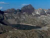 Over Urdiceto dam
Punta Fulsa, sometimes mispelled "Fuesa" on some maps, is the "little sister" of the Punta Suelza. From the purely geographic SP point of view, introducing this secondary summit can seem odd, but Fulsa is such a beautiful summit, with such interesting routes, that this top deserves a page, even if a significant part of the practical informations (getting there, accomodations) is kind of duplicated.
Punta Fulsa is only a hundred meters lower than Big Sister, but is shapes is making a stark contrast, especially seen from the north: Fulsa is as thin and sharp as Suelza is big and round. Both are made of the same red sandstone, however the NW side of the mountain switches surprisingly to granite.
Apart from the Urdiceto track, just like Suelza again, the routes to this peak visit some of the wildest areas of this part of the Pyrenees. The chances that you meet no one else during the hike are quite high. However, as for wildlife, very thin: avoiding the crowds of Isards (the Pyrenean Chamois) will be difficult !
From the top, the views are, as you guessed, astonishing. If the remote peaks (Cotiella, etc) look quite the same than from Suelza, we are much closer to Monte Perdido, just in the alignment of the Pineta valley, into which we can see until the north end, till Pic de Pineta. The Bachimala and Batoua are more hidden by the mass of the Suelza, but this is actually a viewpoint to watch the latter under its proudest angle. The Lago del Cao looks incredibly deep and the mountain looks like some sharp volcano.
Finally, and this time unlike the Suelza, the first climb is not anonymous, and was done by Antonin Lacotte-Minard in 1876.
 Suelza & Fulsa from Urdiceto pass
Getting There
 Fulsa and Suelza from the Comodoto
 From Port de Plan
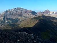 Suelza & Fulsa from Peña Blanca
 Hiding behind...
 In the distance
 From The Suelza south slopes
 Fulsa from Lago d'Urdiceto
The Punta Fulsa lies in Spain, but quite close to the border. Most trailheads are in Spain, but it is also possible to hike this mountain from France and returning the same day.
1/ The most popular trailhead is the track starting over Parzán, very close to the border, (petrol station), heading to the artificial lake of Urdiceto ("Embalse Urdiceto"). This track is convenient for land-rovers and usual cars high on wheels. This is a bit the "lazy" way to reach the mountain, unfortunately popular amongst eased spanish tourists owning expensive land rovers. This takes us at the foot of the mountain, but not exactly the best for the one who seeks tranquility...
2/ Another approach reaches the same point coming from the continuity of this track in the east (path GR11), which elevates from the valley of La Pez and the Tabernés hut. But this is a very remote area by car, reacheable from the very end of the Gistaín valley. Over the village of San Juan de Plan, a very long track goes north. We leave on the right the juction to Viados Barns, and park at Tabernés. It is really worth starting from here only if we have planned other ascents in the area for the next days (Posets, Bachimala...)
3/ A beautiful, and not very popular trailhead, is the one which starts at the sawmill down from the village of Bielsa. One must drive up a wild and shap landrover track until it divides between two valleys, at the level of ruins of farms. There is barely the space to park one vehicle there. The left valley is the one that has the most passable hiking trail, leading to Ibón del Cao, and marked in yellow.
4/ The only trailhead from France starts at the end of the Rioumajou valley (routes to Lustou and Batoua too). Instead of heading to these peaks we choose the trail to Port d'Ourdissetou (french name of "Urdiceto"). Behind this pass lie the lake of Urdiceto already described, so this is just a longer appoach but more beautiful.
View Larger Map
Routes
 Suelza & Fulsa from Peña Blanca
 Summit ridge (Route 1, Arlaud)
 From Col. Cruz de Guardia (route 3)
 North ridge (route 4)
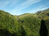 Tabernes route (route 2)
 Looking down to Lago Del Cao
 Summit view to Urdiceto lake
 Trail to Port d'Ourdissetou (Route 5)
 Port d'Ourdissetou
 Rioumajou waterfall
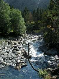 Cinqueta de la Pez
1/ From Lago d'Urdiceto
This is from far the shortest route and most direct. From the lake, reaching the Breach of Fulsa (sometimes also named Collata el Cao, or Collado de Suelza) on a short but strenuous walk on instable boulders. From there, we scramble easily to the summit. In a couple of places, the route goes from one side of the ridge to the other, but remains always obvious. This is not difficult route but the rock is loose, so beware. This route is named after the early pyreneist Jean Arlaud, who was probably one of the first (but not "the") to ascend and describe it.
2/ From Tabernés
From the hut (maybe slightly more south than the hut), take the marked trail GR11 in the direction of Collado de Urdizeto. Later, we reach endless pastures of the Plan valley. I have personally never walked this trail but having watched both of its ends, it looks very beautiful and wild. Once we reach the pass and the lake, the route to the top is identical to 1.
3/ From the Bielsa sawmill
This route is described here in this site (french). From the ruins, elevate in the forest following the yellow marks. These marks are not always very visible and we must pay attention. During a significant section, they are absent and we just need to follow the shore of the stream (and not struggle in the steep forest to find the next marks). Out of the forest a wide view opens, with Peña Montañesa and Pineta valley in the background. We follow a large pasture that leads to Ibón del Cao, a surprising round-shaped lake, like a crater. From here, we can reach the Breach of Fulsa, and scramble to the top like route 1.
4/ By the north ridge
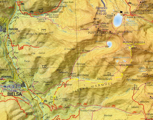
Probably the less known road, and most difficult, as it apparently involves rock-climbing. I have never done it neither know anyone who did. It is very rarely described and I know its existence only by a short mention in the Angulo guide. This is one of the numerous route discovered by Georges Ledormeur , called after him on the maps "Editorial Pirineo", and graded II. The trailhead is the start of the 4x4 track leading to Urdiceto but the route leaves it soon to climb into a valley named "Follarata". It ends at a breach north from the Fulsa, Collado de Fulsa/Fuesa. There starts to route which reaches the summit. Note that the rock is granitic on this side, which is much better than the usual brittle red sandstones on the rest of the range. The route can be visualized on this map (image below).
5/ From Rioumajou
We describe only the way from Rioumajou until Lago d'Urdiceto, as the rest is identical to 1 again. From the Hospice de Rioumajou, pass the wooden bridge and reach the junction between Port d'Ourdissetou and Port de Plan; choose the first of the two, which is since recently an official way of Compostella. An easy track leads to Port d'Ourdissetou, a wide pass (in Spanish, spelled in thousands ways depending on maps : Ordiceto, Ordizeto, Urdiceto...). Behind, the trail goes down a hundred meters. We don't need to get down to the shore of the lake if we plan to climb the north ridge of the mountain. Under the pass on the french side lies also a pretty small lake worth seeing.
Port d'Ordiceto is a very old and famous passage between Spain and France, with many various, sometimes tragic episodes in the history.
During all times, Spanish peasants used to cross and help the French ones during their harvest season, and same for the French the other way.
In the spanish civil war, many escaped to France this way. In the second war, french resistants also used to escape the german repression.
Many people in the Aure and Louron valleys have "Gistain" or "Chistau" as Patronyms (name of the neighbouring spanish valley), which attests the oldness of this migratory fluctuations.
The main interest of this route is historical, but not only. Also to feel the steer contrast between the greenness of the north side, and the desertic mineral landscapes discovered later.
 |
Camping, Huts and other Cabañas
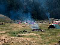 Rioumajou bivouac area
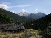 Cabaña de Culrueba
 Tabernés hut
 Hospice du Rioumajou
The possibilities to wildcamp are almost unlimited such the area is rich in flat and grassy desertic areas.
Otherwise there are few interesting possibilities to sleep in few huts :
* At the Hospice du Rioumajou, it is officially allowed to camp next to it during summer. During winter, a small room (no equipment) is open.
* At the Urdiceto lake, there are several possibilities : a mountain-hut is currently under construction, while 2 other huts are available around, a nice one at Collado de Urdiceto and a very basic one near the lake.
* In the valley of La Pez is located the non-guarded hut (exagerately called "refugio"...). Like a bit canteen, a bit gloomy and dirty, but makes a reliable shelter in case of rain. Otherwise, camping in the neighbouring grassy fields is much nicer. In the same valley exsists another hut, Cabaña de Culrueba, a bit higher, still not far from the GR11 juntion.
As for standard accomodations on each side, there are numerous possibilities in the sourroundings of Bielsa, in the Gistaín valley or the
Aure Valley on the french side (with official campsites there).