
|
|
Mountain/Rock |
|---|---|
|
|
42.65417°N / 0.28702°E |
|
|
Hiking, Mountaineering, Mixed, Scrambling, Skiing |
|
|
Spring, Summer, Fall, Winter |
|
|
9751 ft / 2972 m |
|
|
Overview
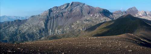
 Ibónes de Barleto
 From Peña Blanca
 From Urdiceto
 From Bachimala
 Barleto lake
 From Cotiella
 From Forqueta
  From Urdiceto From Urdiceto |
Encircled by a club of superstars like the Monte Perdido, the Cotiella, the Posets, the Bachimala, or the Batoua, this mountain remains a real no-man's land in the High Aragon, where one will barely meet any other hikers, even during the high season.
This can be partly explained by the fact that the Punta Suelza (also commonly named Suelsa; the french spelling tends to use S while the spanish Z), neither her shap neighbour the Fulsa, are three-thousanders. They also do not offer many interesting climbing or scrambling routes, as the rock is very brittle. But, in winter, its rectilign and smooth southern slope is appreciated by the skiers.
Note : the area is threatened by a pharaonic project of ski resort :(
This range is extremely interesting from a geological point of view (see this link), and owns many unusual features, such as lakes on non-granitic ground. Limestone, granit, red grit, schists, everything can be found within a quite small area. But the rock that characterizes the most the Punta Suelza is the red grit, which gives to the mountain its specific and unique pink-red colour.
Count Henry Russell, who undertook the first "known ascent" in late July 1874 (instead of the real first, as he found ruins of a hut on it!), described the mountain "as if a bucket of spannish wine, or blood, was poured on it".
Huge herds of Isards (Pyrenean Chamois) can also be met in these raw wildernesses, as well as crowds of marmots.
Despite the lack of "hiking infrastructures", the Suelza is a must-see for the amators of this region of the Pyrenees, and deserves well a visit !
Getting There
 from Peña Blanca ridge from Peña Blanca ridge |
 from Peña Blanca ridge from Peña Blanca ridge |
 Gistaín valley
 Village of Sin
 Ibón del Cao
 Ibónes de Barleto
 Urdiceto valley
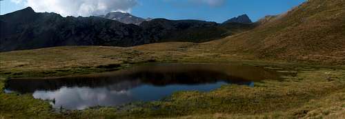
 Lago de Urdiceto
 Rioumajou
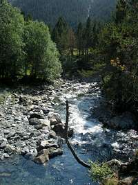 La Pez valley
The Punta Suelza lies in Spain, but quite close to the border. Most trailheads are in Spain, but it is also possible to hike this mountain from France and returning the same day.
1/ The most common, easiest despite also longest, is from the south, and the Collado de la Cruz de Guardia, a very remote place in the valley of Gistaín. One must drive up the main road to the Bielsa tunnel, but turn before at the junction of Salinas, in the direction of Sarravillo. At Sarravillo (traihead of the Cotiella), take instead the north junction heading to the small villages of Sin, Serveto, and Señes. All three beautiful villages with characteristic architecture of the region, with constructions made of flat dry stones. Over Serveto, the road becomes a track and leads to a vast landscapes of pastures, almost until the pass named Collado de la Cruz de Guardia. The track goes down to Gistaín, other village in the valley which also makes an access to the same place, despite more distant from the main road. Nearby is located a sherperd hut opened to hikers (more information needed, I haven't slept in it). Usually, considering how long is the approach by car, hikers tend to sleep or bicouac here to start the next day.
2/ A beautiful, and not very popular trailhead, is the one which starts at the sawmill down from the village of Bielsa. One must drive up a wild and shap landrover track until it divides between two valleys, at the level of ruins of farms. There is barely the space to park one vehicle there. The left valley is the one that has the most passable hiking trail, leading to Ibón del Cao, and marked in yellow.
3/ The other very popular trailhead and last in Spain, is the track starting over Parzán, very close to the border, (petrol station), heading to the artificial lake of Urdiceto ("Embalse Urdiceto"). This track is convenient for land-rovers and usual cars high on wheels. This is a bit the "lazy" way to reach the mountain, unfortunately popular amongst eased spanish tourists owning expensive land rovers. This takes us at the foot of the mountain, but not exactly the best for the one who seeks tranquility...
4/ Another approach reaches the same point coming from the continuity of this track in the east (path GR11), which elevates from the valley of La Pez and the Tabernés hut. But this is a very remote area by car, reacheable from the very end of the Gistaín valley. Over the village of San Juan de Plan, a very long track goes north. We leave on the right the juction to Viados Barns, and park at Tabernés. It is really worth starting from here only if we have planned other ascents in the area for the next days (Posets, Bachimala...)
5/ The only trailhead from France starts at the end of the Rioumajou valley (routes to Lustou and Batoua too). Instead of heading to these peaks we choose the trail to Port d'Ourdissetou (french name of "Urdiceto"). Behind this pass lie the lake of Urdiceto already described, so this is just a longer appoach but more beautiful.
View Larger Map
Routes
 From Port de Plan From Port de Plan |
 From Port d'Ourdissetou From Port d'Ourdissetou |
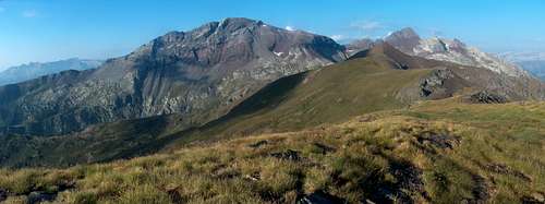
 Gistaín valley from Collado de la Cruz de Guardia
 near Collado de la Cruz de Guardia
 to Ibón del Cao
 Ibón del Cao from Fulsa breach
 Suelza from Urdiceto
 South slope of Suelza
 Valley of Plan
 Stream in La Pez valley
 Hospice du Rioumajou
 Rioumajou trail
 Port d'ourdissetou
 Rioumajou valley
 Port d'ourdissetou
 Port d'ourdissetou
 Port d'ourdissetou
 Rioumajou trailhead
 Frédançon in Rioumajou
 Frédançon in Rioumajou
Let's continue the previous chapter describing now all routes corresponding to all trailheads...
1/ From Collado de la Cruz de Guardia
This is the only winter route for skiers. Once we reach the pass Cruz de Guardia, we discover a landscape of wide open grassy pastures. The track continues on a slope inclided to the west. We pass a junction whose track on the left comes from nowhere (indeed it is the former trail from the wild valley described in the end of next paragraph). The track stops as we reach the lakes Ibónes de Barleto, and the vast uniform south slope of the Punta Suelza. We only need to head straight forward and walk to the summit, making zigzags between the outcrops of red grit till the top. The route is very accurately described in this page.
2/ From the Bielsa sawmill
From the ruins, elevate in the forest following the yellow marks. These marks are not always very visible and we must pay attention. During a significant section, they are absent and we just need to follow the shore of the stream (and not struggle in the steep forest to find the next marks)
Out of the forest a wide view opens, with Peña Montañesa and Pineta valley in the background. We follow a large pasture that leads to Ibón del Cao, a surprising round-shaped lake, like a crater.
From here, we can either reach the Breach of Fulsa (sometimes also named Collata el Cao), and scramble the NW ridge of the mountain (2a), or either scramble a corrie west from the lake, that leads to the southern slopes of the Suelza (2b).
The return can be made visiting the lakes Ibónes de Barleto, and descend through the second valley. But one must be aware that there is not trail at all, and needs to cross some difficult areas with dense vegetation and fallen trees.
3/ From Lago d'Urdiceto
From this lake, two routes involving scambles are leading to the top, and can be made as a loop. The first option (3a) consists in heading from the east bank of the lake to pass sometimes named Collado de Suelza, sometimes Collado de Gistaín, or even Collado de Urdiceto (not to mix with Puerto de Urdiceto, route 4). From there, we scramble easily to the summit via the north ridge. This is generally considered as the usual route. The second (3b), just like for going to Punta Fulsa, consists in reaching the Breach of Fulsa. The rest is identical to the route 2b.
4/ From Tabernés
From the hut (maybe slightly more south than the hut), take the marked trail GR11 in the direction of Collado de Urdizeto. Later, we reach endless pastures of the Plan valley. I have personally never walked this trail but having seen both of its ends (La Pez and Plan pastures) I have the strong feeling it is a very beautiful one.
5/ From Rioumajou
We describe only the way from Rioumajou until Lago d'Urdiceto, as the rest is identical to point 3. From the Hospice de Rioumajou, pass the wooden bridge and reach the junction between Port d'Ourdissetou and Port de Plan; choose the first of the two, which is since recently an official way of Compostella. An easy track leads to Port d'Ourdissetou, a wide pass (in Spanish, spelled in thousands ways depending on maps : Ordiceto, Ordizeto, Urdiceto...). Behind, the trail goes down a hundred meters. We don't need to get down to the shore of the lake if we plan to climb the north ridge of the mountain. Under the pass on the french side lies also a pretty small lake worth seeing.
 Rioumajou valley, trailhead to Ourdissetou Rioumajou valley, trailhead to Ourdissetou |
Port d'Ordiceto is a very old and famous passage between Spain and France, with many various, sometimes tragic episodes in the history.
During all times, Spanish peasants used to cross and help the French ones during their harvest season, and same for the French the other way.
In the spanish civil war, many escaped to France this way. In the second war, french resistants also used to escape the german repression.
Many people in the Aure and Louron valleys have "Gistain" or "Chistau" as Patronyms (name of the neighbouring spanish valley), which attests the oldness of this migratory fluctuations.
The main interest of this route is historical, but not only. Also to feel the steer contrast between the greenness of the north side, and the desertic mineral landscapes discovered later.
 Routes schema Routes schema |
Red Tape
Instead of a red tape we have a red mountain :) Wild area ! Panorama from near the Batoua
Camping, Huts and other Cabañas
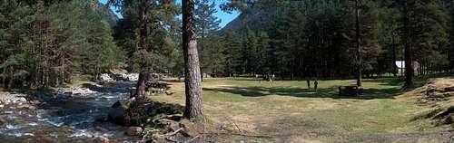
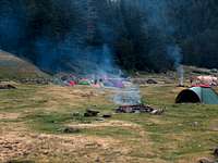 Rioumajou bivouac area
 Cabana du Collado de Pegueras
 Tabernés hut
 Hospice du Rioumajou
 Tabernés hut
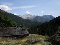 Cabaña de Culrueba
 Rioumajou valley, trailhead to Ourdissetou Rioumajou valley, trailhead to Ourdissetou |
The possibilities to wildcamp are almost unlimited such the area is rich in flat and grassy desertic areas.
Otherwise there are few interesting possibilities to sleep in few huts :
* At the Hospice du Rioumajou, it is officially allowed to camp next to it during summer. During winter, a small room (no equipment) is open.
* At the Urdiceto lake, there are several possibilities : a mountain-hut is currently under construction, while 2 other huts are available around, a nice one at Collado de Urdiceto and a very basic one near the lake.
* At Collado de la Cruz de Guardia, is located a hut (informations still to find !). Another one at Collado de Pegueras
* In the valley of La Pez is located the non-guarded hut (exagerately called "refugio"...). Like a bit canteen, a bit gloomy and dirty, but makes a reliable shelter in case of rain. Otherwise, camping in the neighbouring grassy fields is much nicer. In the same valley exsists another hut, Cabaña de Culrueba, a bit higher, still not far from the GR11 juntion.
As for standard accomodations on each side, there are numerous possibilities in the sourroundings of Bielsa, in the Gistaín valley or the
Aure Valley on the french side (with official campsites there).
 Rioumajou valley, trailhead to Ourdissetou Rioumajou valley, trailhead to Ourdissetou |