
|
|
Mountain/Rock |
|---|---|
|
|
42.68294°N / 0.32066°E |
|
|
Huesca |
|
|
Hiking, Mountaineering, Skiing |
|
|
Spring, Summer, Fall, Winter |
|
|
8802 ft / 2683 m |
|
|
Overview
 Pène de Millarioux from the Peña Blanca
 On the desertic ridge of the Peña Blanca
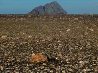 Peña Blanca ridge
 Peña Blanca ridge
 Peña Blanca ridge
 Peña Blanca ridge
 Urdiceto ridge
 Peña Blanca ridge
 Peña Blanca ridge
 Loneliness...
 Peña Blanca view
 On the top of the Pène de Millarioux, looking SW to the Peña Blanca, with Suelsa and Fulsa behind On the top of the Pène de Millarioux, looking SW to the Peña Blanca, with Suelsa and Fulsa behind |
This Peña Blanca shouldn't be mixed with its homonym (neighbour of Aspe).
Ours is rather a neighbour of the Batoua, and is as smooth as the other is rugged. There is a french name for it too, but very rarely used: Tuquet de Cauarère. Perhaps because seen from France, it forms an unsignificant corner of Rioumajou valley, while it makes a convex and prominent angle of the the Plan valley.
 Somewhere on the Peña Blanca ridge, looking to the Suelsa, Fulsa, and Rioumajou peaks Somewhere on the Peña Blanca ridge, looking to the Suelsa, Fulsa, and Rioumajou peaks |
Peña Blanca lies on the french-spanish border, between the two mentionned valleys, about half way between the Batoua and the Suelza.
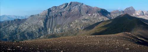
For its height neighbouring the 2700m, usually a leval where peaks start to ressemble real peaks, is surprisingly not very impressive, a big dome of dark brittle slate rocks, where one with little imagination, could easily picture himself in the And's Altiplano or Iceland's fells.
 On the desertic ridge of the Peña Blanca, at the pass Port de Plan looking down the valley On the desertic ridge of the Peña Blanca, at the pass Port de Plan looking down the valley |
This area is totally unfrequented, except in the winter season when it gets all the fame for being a splendid area for ski-touring.
However, during the rest of the year, this hike (not only Peña Blanca but all the ridge, until Pico de Urdiceto) provides disorienting and exhilarating feeling of exploring a wild desolated area, in an uncommon landscape in the Pyrenees, of high interest geologically speaking.
Just a couple of hundred meters north stands a curious outcrop, Pène de Millarioux (2699), much more noticeable, and partly made of limestone. This bright rock contrasting with the rest might be at the origin of the main peak name Peña Blanca, "white peak".
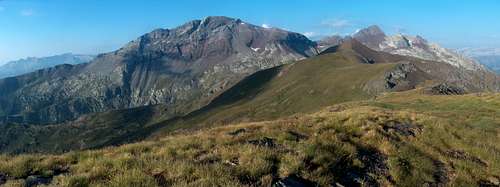
It is more than adviseable to visit not only the Peña Blanca but the whole portion of this ridge, from Pène de Millarioux to the Pico de Urdiceto, an interesting peak, offering splendid views to the Suelza and made of the same red rocks. A passionating geologic exploration, rich in colours and tones.
 Somewhere on the Rioumajou ridge, looking to the Batoua (left), Pène de Millarioux (middle) and Peña Blanca (right) Somewhere on the Rioumajou ridge, looking to the Batoua (left), Pène de Millarioux (middle) and Peña Blanca (right) |
Getting There
 Urdiceto, West ridge
 Descending Urdiceto
 Descending Urdiceto
 Descending Urdiceto
 Fulsa in the distance
 Rioumajou waterfall
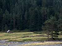 Rioumajou forest
 Rioumajou forest
 Cotiella
 Eriste
 Sunrise in the Rioumajou valley Sunrise in the Rioumajou valley |
The Peña Blanca lies on the border. Trailheads can be both in Spain or France.
The spanish one is quite long to reach, in the very end of the Gistaín valley on a land-rover track, a very remote area by car. It elevates from the valley of La Pez and the Tabernés hut. Over the village of San Juan de Plan, a very long track goes north. We leave on the right the juction to Viados Barns, and park at Tabernés. It is really worth coming in this location only if we have planned other ascents in the area for the next days (Posets, Bachimala, Suelza...)
From France, it starts at the end of the Rioumajou valley, identically as for the Batoua.
 On the Rioumajou ridge near Port de Plan, looking to the Suelsa & Fulsa On the Rioumajou ridge near Port de Plan, looking to the Suelsa & Fulsa |
View Larger Map
 Somewhere on the Peña Blanca ridge, looking to the Suelsa & Fulsa Somewhere on the Peña Blanca ridge, looking to the Suelsa & Fulsa |
Red Tape
 Lago de Trigonero
  Rioumajou by night...
None as far as I know. Perhaps the area in the Pyrenees with the lowest level of red tape !
 Rioumajou valley, Batoua on the left, Peña Blanca on the right
Routes
 Bachimala from Madèra route
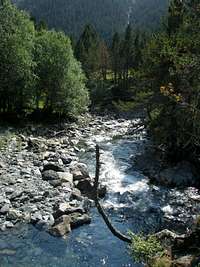 Cinqueta de la Pez
 Madèra trail starts
 Port de la Madèra
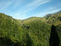 Barranco de la Madèra
 Port de la Madèra
 Valley of Plan
 Under the Pène de Millarioux
 Heading to Port de Cauarère
 Port de Plan
 near Port de Plan
 Heading to Urdiceto
 Urdiceto descent
 Urdiceto, with Fulsa behind
 Port d'Urdiceto
 Rioumajou trailhead
 Bachimala and Posets from the route to Port de la Madèra Bachimala and Posets from the route to Port de la Madèra |
Two routes, one for each side, are usually taken :
* Spanish side :
From the Refugio de Tabernès, a trail heads West, along the north side of the stream Barranco de la Madera, and leads to the pass Port de la Madèra, which is nothing else than Port de Cauarère in french. From there, we can either circumvent or climb the Pène de Millarioux, this surprising strange outcrop, which offers an interesting viewpoint to the Batoua. Then, after a walk down we reach the Peña Blanca, slightly higher, after a gradual climb. The return is made the same way, but a loop is possible while going down south from Port de Plan. It leads to a point of the track quite far from Tabernès, below the junction to the Viados barns, and involves a significant walk to get back to the vehicle.
 On the top of the Pène de Millarioux. Batoua in the distance On the top of the Pène de Millarioux. Batoua in the distance |
* French side :
From the Hospice the Rioumajou, when we reach the junction between
Port de Cauarère and port de Plan, it can be reached via both ways. The walk to Port de Cauarère is steeper then it can be advised to take it on the way up. At one point, as we reach the upper side of the forest, we discover a wide black slope made of slate screes slowly decreasing, in which we can easily decide which point of the crest we plan to reach. The Pène de Millarioux and the Peña Blanca are visited as described for the spanish route, and the descent can be made as soon as we reach Port de Plan. However it is more than adviseable to bag Pic d'Ourdissetou (Pico de Urdiceto), and descend via the eponym pass to Rioumajou. The portion from that peak to the pass, unless we descend significantly to avoid it, is full of easy scrambles, but on loose rock. Don't miss the photogenic little lake near Tuque d'Endure on the way down.
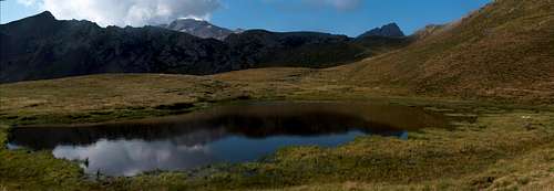 Lake near Tuque d'Endure. Suelza in the distance Lake near Tuque d'Endure. Suelza in the distance |
 Looking to the Robiñera and Munia from Pico d'Ordiceto Looking to the Robiñera and Munia from Pico d'Ordiceto |
 Lake near Tuque d'Endure. Batoua in the distance Lake near Tuque d'Endure. Batoua in the distance |  Lake near Tuque d'Endure, overlooking Rioumajou valley Lake near Tuque d'Endure, overlooking Rioumajou valley |
Camping, Huts and other Cabañas
 Tabernés hut
 Hospice du Rioumajou
 Tabernés hut
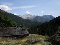 Cabaña de Culrueba
 Rioumajou trail
 Rioumajou trail
 Rioumajou valley, trailhead to Ourdissetou Rioumajou valley, trailhead to Ourdissetou |
The possibilities to wildcamp are almost unlimited such the area is rich in flat and grassy desertic areas, especially on the spanish side.
Otherwise there are few interesting possibilities to sleep in few huts :
* At the Hospice du Rioumajou, it is officially allowed to camp next to it during summer. During winter, a small room (no equipment) is open.
* In the valley of La Pez is located the non-guarded hut (exagerately called "refugio"...). Like a bit canteen, a bit gloomy and dirty, but makes a reliable shelter in case of rain. Otherwise, camping in the neighbouring grassy fields is much nicer. In the same valley exsists another hut, Cabaña de Culrueba, a bit higher, still not far from the GR11 juntion.
* At the Urdiceto lake, there are several possibilities : a mountain-hut is currently under construction, while 2 other huts are available around, a nice one at Collado de Urdiceto and a very basic one near the lake.
As for standard accomodations on each side, there are numerous possibilities in the sourroundings of Bielsa, in the Gistaín valley or the
Aure Valley on the french side (with official campsites there).
 Rioumajou valley, trailhead to Ourdissetou Rioumajou valley, trailhead to Ourdissetou |