
|
|
Mountain/Rock |
|---|---|
|
|
42.54625°N / 0.34676°E |
|
|
Sobrarbe |
|
|
Hiking, Mountaineering, Mixed, Scrambling, Skiing |
|
|
Spring, Summer, Fall, Winter |
|
|
8694 ft / 2650 m |
|
|
Overview
 Once (left) and Llosat (right)
 Ibón de Plan
 Once & Cotiella in the distance
 From Collado de Sahún
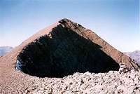 Summit ridge
 Once, Llosat & Alta
 Range from the north
 Gistaín villages from the top
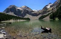 Ibón de Plan
 Ibón de Plan
 Lake shores...
 Lake shores...
 Lake shores...
 Lake shores...
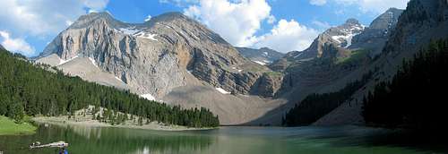 Ibón de Plan (Basa de la Mora)
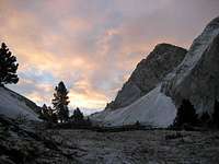
Peña de las Once belongs to the Cotiella range (the widest massif in the Pyrenees!). Failing to be the second highest top, it is on the other hand and without any doubt its second most individualized summit.
It lies on its northernmost end, overlooking the Gistaín valley, and remains separated from the Llosat, Ribereta, Coronas and Espouy ridge by a wide pass, the Colladeta del Ibón. This pass is the only one that links directly the western and the eastern mountainside (Circo de Armeña) in the whole mountain.
This "gap" makes the Peña de las Once easily recognizeable in the skyline, everywhere from where the Cotiella can be seen.
 Summit panorama from Peña de las Once Summit panorama from Peña de las Once |
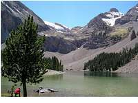
But, above all, bagging the Peña de las Once is the best pretext to visit the most beautiful site of the Cotiella range, an unique pearl in the whole Pyrenees: the lake Ibón de Plan (called also Basa de la Mora); a visit that most popular routes to the main top of the Cotiella avoid.
This is a wide lake nestled in the heart of the massif on its north side. Surprisinly, this lake lies on limestone ground, and its superficy is considerable. The bright stones make beautiful emerald tones through the water, in which are reflecting the walls of the surrounding mountains.
Set as a wide amphitheater, their twisted layered slices witness the sedimentary nature of the geology. From the vertical orientation near the pass, they progressively switch to horizontal as the sight goes south, like a collapsing shelve of books. When a slight snow underlines these details, the beauty of the site is amazing, and more than one visitor compared this view to Canada's Banff Moraine lake.
Unfortunately, the nature of the terrain makes this moraine lake subject to important changes of level, and one can find it abnormally low at the end of the summer. The dead trees lying far from the shore also suggest it was once much smaller, and long-ago pioneers like Russell described it completely different as nowadays as well.
One must keep it mind that its presence is very ephemeral at the scale of nature, and given how fast landscape is changing here (we can constantly hear the noice of some brittle cornice collapsing under its own weight !), it may not exist anymore in some centuries or so.
 From the Gistaín valley From the Gistaín valley |
Coming back to our Peña de las Once, the peak presents a layered shape that corresponds perfectly to the previous description. The originality of the top is that it allows unusually wide angles to the north. The views to the Gistaín valley, to the Monte Perdido, to the Posets and the Maladeta are stunning.
Peña de las Once, in analogy with Peña d'El Mediodía, Peña de la Una and Peña de las Diez, were named so by the inhabitants of the Gistaín valley, who used the range's tops as marks like on a giant solar clock: Diez showed 10am, Once 11am, Mediodía 12am, and Una 1pm. Practical for the working times and the lunch break !
And from close viewpoints like the Punta Maristás, the sights to the Cotiella, with the cliffs of Peña de las Once in foreground, are particularly nice to admire.
 From the Gistaín valley From the Gistaín valley |
 From the Gistaín valley From the Gistaín valley |
 From the Gistaín valley From the Gistaín valley |
 Ibon de Plan Ibon de Plan |
Getting There
 Perdido view
 Perdido view
 Bachimala view
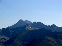 Posets view
 Llavasar view
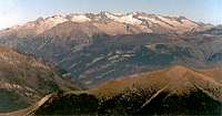 Maladeta View
 Once summit ridge
 Gistaín valley from the top
 Ibón de Plan (Basa de la Mora)
 Ibón de Plan in winter
 Edelweiss
 Peña de las Diez
 Peña de las Once Peña de las Once |
The mountain can be reached either from the East and the West, and consequently has two possible access, then two possible trailheads.
Both are equally accessible from Lleida in Spain, but only the western one, Sarravillo, is convenient for those who crossed the french border by the tunnel, in order to avoid a large diversion to reach Barbaruens.
Saravillo is easily accessible in the valley of the Rio Cinca, taking the junction into the Gistaín valley at the level of Salinas. We can park in Saravillo village, but there is not much space for parking.
Barbaruens is accessible via Benabarre, Graus and Campo. For reaching it via the Bielsa valley, the closest road is not earlier than south from the Peña Montanesa, via Foradada del Toscar. Google maps shows a possible way via Collado de Sahún, but driving this track, about in the same state as the one that heads to Llavasar, is not advised at all, unless we plan to hike a mountain there...
View Larger Map
 Peña de las Diez Peña de las Diez |
 Hike from Saravillo Hike from Saravillo |
 Hike from Saravillo Hike from Saravillo |
 Hike from Saravillo Hike from Saravillo |
 Colladeta del Ibón Colladeta del Ibón |
Routes
 Colladeta del Ibón in sunrise
 Colladeta del Ibón
 Lake from Colladeta del Ibón
 Colladeta del Ibón
 Colladeta del Ibón
 Colladeta del Ibón
 Colladeta from Armeña side
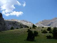 Colladeta from Armeña side
 Summit ridge
 Summit view
 Summit view
 Summit view
 Ibón de Plan (Basa de la Mora)
 Ibón de Plan
 Ibón de Plan
 Ibón de Plan
Depending on where we come from (see Getting there), there are two routes to reach the peak, on each side of the pass Colladeta del Ibón. I, the author of this page, have walked only the first one. Despite both lie along the main long distance GR 15 hiking path, the description of the east side is purely "theorical" and additional details are more than welcome.
 Ibón de Plan Ibón de Plan |
1/ West side, from Saravillo
From Saravillo, we can either choose to start the hike at the village itself, or get by car to the Llavasar hut via the land-rover track, but this one is in extremely bad state and it is advised to have a car with a high ground clearance. In all cases the drive is made very slowly and getting to Llavasar takes almost 1h, so the hiking option shouln't be discarded too quickly ! And Peña de las Once is kind of quickly accessible from Llavasar, so adding the Saravillo ascent to make it a full day hike is not a bad idea at all.
The trail that leaves Saravillo to Llavasar is well marked with the usual red-white marks of the GR15. It goes and elevates gradually in a beautiful forest of pines. Few points unveil fine and unusual views around.
If we use on the opposite the track, do not forget to turn left at a junction where the right one leads to pass Santa Isabel instead of Llavasar.
Llavasar is a beautiful site, on a clearing with open views to the Monte Perdido range. A popular hut that can be used for bivouacking stands there. Llavasar is named so, after the nearby Valley of Llavasar and its famous "needles", a possible route for those who head to the Cotiella.
From the Llavasar hut, the trail goes down a bit over a cracked and dry limestone ground, and goes aside the mountain slope for a while. Then we reach a wide meadow that gives a foretaste of the site of Ibón de Plan.
Then, the lakes appears with all its splendour. The north shore is usually the official photo point for a panorama. Then we hike the east shore (the other isn't really accessible), on a stripe of grass sometimes narrow between pines and water.
The south end of the lake, can be shortly explored before we ascend the pass Colladeta del Ibón. The terrain to the pass is a pile of fallen stones of different sizes, that makes it a difficult terrain to walk on in few places. As we reach Colladeta del Ibón, the view to Armeña unveils, with the Turbón in the background.
The end of the route, common part with the next below, consists in walking the ridge, on bare limestone ground, sometimes brittle, to the top.
2/ East side, from Barbaruens
From Barbaruens, the trail GR15 elevates though La Lloseta, and then follows for a wile a large track that runs parallel to the mountainside.
From there, the map shows two ways to access the Circo de Armeña: following the valley of Barranco de Bilsé, or catching the upper trail on the south that reaches directly Ibon de Armeña, Cotiella's second lake in the whole range. Both trails converge again as we reach Refugio de Armeña, a popular unguarded mountain hut.
From the Refugio, the GR 15 elevates north in the direction of the pass Colladeta del Ibón, where we meet the end of the route previously described.
|

 Ibón de Plan Ibón de Plan |
 Llavasar hut Llavasar hut |
 Armeña hut Armeña hut |
 Llavasar hut Llavasar hut |
 Full ! Full ! |
 West panorama from Llavasar West panorama from Llavasar |
Camping
[img:654368:alignleft:small:Armeña hut][img:458668:alignright:small:Llavasar hut][img:674696:alignleft:small:Armeña hut][img:674703:alignright:small:Llavasar hut][img:674695:alignleft:small:Full !][img:653244:alignright:small:Empty, just for Ojo & friend :)]There is no guarded mountain hut in the whole area.
Only the two previously ungarded huts are available.
* Llavasar is a very basic construction, with few furnitures inside, but the construction is very good, modern, and the chimney works well. Wood is not rare and water is flowing nearby. This hut has a less touristic vocation than the Armeña and looks partly built for sherpering purposes.
* Armeña is a construction definitely for hiking purposes, with all equipment inside (emergency phone, etc), but the construction tends to be popular and full on week-ends. Lake Armeña is 15mn away. Wood and water can be found nearby.
Both huts stand on grassy terrain on which one can pitch a tent without any problem. Ibón de Plan can also be a good (and romantic !) spot.
| [img:673111:aligncenter:medium:West panorama from Llavasar] |