

-
 11991 Hits
-
 88.19% Score
-
 26 Votes
|
|
Mountain/Rock |
|---|---|
|
|
45.73460°N / 6.81311°E |
|
|
Valle d'Aosta |
|
|
Mountaineering |
|
|
Spring, Summer |
|
|
10262 ft / 3128 m |
|
|
Overview
Punta Léchaud 3128 m
Punta Léchaud 3128 m is a mountain belonging to the Graie Alps, Gran Sassière and Rutor group, located on the border line between Valle d'Aosta (Italy) and Savoie (France). It is located to the South of Col de la Seigne 2512 m, between Val Veny and Valle dei Ghiacciai. Punta Lechaud is the highest peak among those ones located on the border ridge between the Piccolo San Bernardo and the Col de la Seigne and the most conspicuous peak of the Chavannes Glacier plateau. The Valle d'Aosta side is characterized by three glaciers connected to each other, while the French side shows a slope of broken rocks.
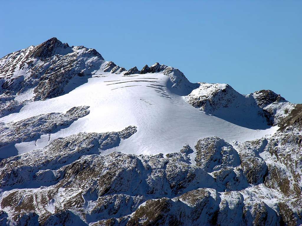
Punta Léchaud has a very important position, indeed it marks an important change of direction of the Western alpine arc. This latter, after heading North, changes its direction just near the Punta Léchaud, starting to curve towards the East. In addition to this, Punta Léchaud is many other things: a little know and lonely goal for a not-too-strenuous day in the Alps, a fantastic panoramic point and a classic ski-alpinism route. All in all, a mountain that deserves to be better known outside the boundaries of Valle D'Aosta.
")
|
 seen...")
|
While thousands of hikers pass near its slopes every year by crossing the Col de La Seigne (on the Tour of the Mont Blanc route), Punta Léchaud is not much known to the mountaineers and more frequented as a ski mountaineering destination. While not part of the Mt Blanc group (actually, it's the last peak of the Northern Graie Alps), Punta Léchaud position as belvedere over the head of the Val Veny, just in front of the Aiguille des Glaciers, makes it a favoured point to observe Monte Bianco in all its western glory.

|

|
Getting There
Road access Access to La Thuile
La Thuile (1430m) can be reached from Geneva via Chamonix, the MB tunnel, Courmayeur and Pre St. Didier. Or from Torino or Milano via Ivrea through the A5 toll highway via Aosta. At the Morgex exit follow the state road SS26 in the Courmayeur direction until Pre St. Didier. In Pre St. Didier follow "La Thuile - Piccolo San Bernardo" indications. The road (after several hairpins) goes up the narrow valley until La Thuile basin (12 km from Pre St. Didier).
- By car: in La Thuile follow the "Piccolo San Bernardo" indications, until the little hamlet of Pont Serrand (car park). The road to the Chavannes Valley and the Pointe Lechaud starts few meters before Pont Serrand, on the right.
- By bus: in summer there's only a daily bus to the Piccolo San Bernardo col (you must stop at Pont Serrand)
Access to Courmayeur
Courmayeur can be reached from Geneva via Chamonix and the Monte Bianco tunnel, or from Milano or Torino via the A5 toll highway
- By car: through the Val Veny mountain road until the car park at La Visaille / Plan Lognan or (500 m. below) at Plan Veny (near the picnic area). Private access to this road is regulated from 1 to 20 August .
- By the bus service: one trip each 40 minutes. In Courmayeur the bus can be taken from the Bus Station (near the tunnel highway entrance).
Punta Lechaud Normal Routes from La Thuile
Punta Léchaud Normal route across Vallone del Breuil
Difficulty: F
Length: 1250 m vertical gain
Starting point: Piano dell'Abbondanza
This itinerary starts from Piano dell'Abbondanza, on the State road n. 26 (Piccolo San Bernardo) near La Thuile, climbs up through the Vallone del Breuil and at the end involves a simple crossing on the Breuil glacier.

Road approach
From La Thuile follow the National road n. 26 of the Piccolo San Bernardo towards the hill until the end of the Plan of the Abundance. Park the car before the first hairpin.
Route report
At the first bend of the state road take the mule track that soon leads to the huts of Balmette 2002 m. Cross the bottom of the Vallone del Breuil to reach the mountain pasture of Balma 2031 m. From the alms follow the path in the North direction, joining the trail coming from Verney. Continue to follow the mule track that cuts the slopes of M. Ouille and Punta Fornet. Once at the head of the valley, the path begins to rise again and reachs the Alpe Le Grotti 2531 m. The trail loses a bit of altitude and then begins to climb again along the left bank orographic of a valley. After a debris slope, you reach the Colle di Bassa Serra 2738 m (3 hours from the start). From the pass you head left (west) crossing some debris floors to reach the beginning of the glacier. Once on the glacier start to bend to the right towards Punta Lechaud. Getting a gully rising towards the summit take it and climb up to the summit ridge. Following the summit ridge up to the summit. (1.30 hours from the Colle di Bassa Serra).
Descent: reversing the same route
Punta Léchaud East route across Col Chavannes
Difficulty: F
Length: 1517 m vertical gain
Starting point: Pont Serrand
This long but extremely atmospheric route can be easily walked as a normal hike. This route starts from the village of Pont Serrand (but most of the people drive up to the Porassey barrier), in the municipality of La Thuile, located 1,5 kilometers far from La Thuile.

|

|
Route report
From Pont Serrand follow the narrow road (asphalt in the first part, then dirt) all the way to the Col de Chavannes 2603 m. The beautiful Chavannes Valley is first a Tolkienesque green valley with huge rock walls on the opposite sides, then opens up near the Berrio Blanc hamlets, where the road makes a huge and gently ascending curve up to the Chavannes Col. At the col, on the right you can see a tiny concrete barrack built as part of the Italy defensive system before WWII.
From the col, take the path on the right (looking towards the Chavannes side - marked "Alta Via 4"). This crosses almost horizontally the steep grassy slope of Mount Lechaud. While elementary, it goes across several gullies, very often snow filled. Be careful expecially on the last one (the biggest).

|

|
The trail then reaches the lonely Chavannes plain, part of the even more lonely and remote Lechaud - Miravidi - Arguerey plateau. Leaft it near a group of beautiful glacial lakes (great place for sunbathing!), then go straight up the moraine and the slopes of the Chavannes glacier, without a fixed path. The glacier itself is easy and relatively safe. Try staying as much as possible on the right, then reach the summit "tower" (actually, a tiny rock lump). Scramble above it and reache the summit platform - then enjoy the view. 1.30h from Col De Chavannes
Descent: reversing the same route.
Access to Chavannes Col from the Val Veny
From the Refuge Elisabetta take the TMB path for few hundred meters, then take the left path marked "Alta Via 2 - Colle Di Chavannes". The trail cross the little valley, and then goes up gently on the opposite side, reaching the Col de Chavannes 2603m. in little more than 1.30h from the Elisabetta.
Red Tape
Until 1992 it used to be possible to drive up to the Combal plan, and even up to the Rifugio Elisabetta (with a four wheel drive vehicle). However, massive rockfalls from the Mont Fortin (on the southern side of the Combal basin) and increasing pollution problems made local authorities decide to put a bar at La Visaille / Plan Lognan. So from here it starts the walk to reach the Refuge Elisabetta, as it used to be until 1970. In the area making fires, free camping under 2500 m. and mineral or flower collection is forbidden. Hunting and fishing goes under local seasonal rules. On the Chavannes versant, there's a bar on the car road at Porassey (small parking just before).
When To Climb
Point Lechaud is an all year round mountain. In summer it has an easy mountaineering target. In winter it is a ski alpinism classic.
Camping and other accomodation
Free camping in the Aosta Valley region is not allowed below 2500 m. However, it's tolerated if you don't create hassles or particular troubles. This includes, of course, making fires in the woods!
- Camping Rutor - Frazione Villaret, 75, 11016 La Thuile http://campingrutor.altervista
- Azzurra Area Camper - Località Villaret, 11016 La Thuile
Here's a list of camping in Val Veny, all accessible by car or by bus from Courmayeur. In strict alphabetical order:
- Camping Aiguille Noire (www.aiguillenoire.com, ) - in Val Veny, at Zerotta, near lower station of the chair lift. (tel. +39 0165 869041 Fax +39 0165 843097). A good place for families and big groups.
- Camping Cuignon – in Val Veny between Zerotta and the military barracks (tel +39 0165 869073 Fax +39 0165 842861).
- Camping La Sorgente (www.campinglasorgente.net ) – in Val Veny, in a clearing of the forest called Peuterey, exactly under the Mont Noir south face (tel. +39 0165 848209 or, in summer +39 0165 869089). The location of this one is gorgeous

- Rifugio Elisabetta at the head of Val Veny near the Col De La Seigne,
Mountain Conditions
For all informations on the mountain conditions you may contact the Company of Guides of Courmayeur (tel. +39 0165 842064; fax. +39 0165 842357; email info@guidecourmayeur.com). They have a local weather service, and are always informed on the conditions up there.
The quickest source of informations on the weather on the southern side of the massif is the webcam at www.valdigne.com. Remember that this cam "sees" only the central portion of the main ridge - Point Lechaud is located three of miles to the left. This very informative site has also plenty of informations on accomodation, place where to eat, etc. in the area.
Meteo
Guidebooks and maps
- Alpi Graie Centrali, Guide dei Monti d'Italia, Alessandro Giorgetta, Milano, 1985