
-
 5125 Hits
-
 80.25% Score
-
 12 Votes
|
|
Mountain/Rock |
|---|---|
|
|
49.20514°N / 7.90707°E |
|
|
Hiking, Trad Climbing, Sport Climbing, Toprope, Scrambling |
|
|
Spring, Summer, Fall |
|
|
958 ft / 292 m |
|
|
Overview
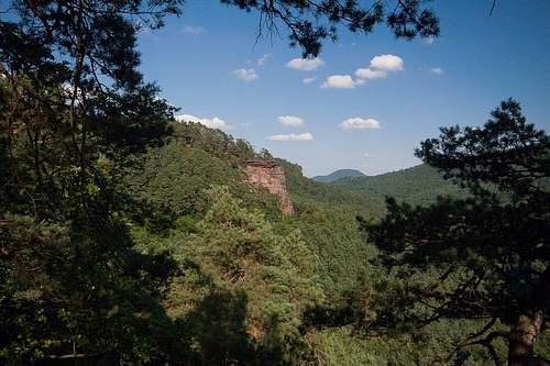
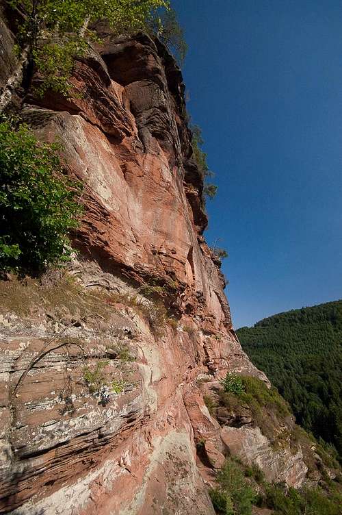 The upper west face of Rindsberg Westpfeiler The upper west face of Rindsberg Westpfeiler |
Among the seven climbing cliffs, which are perfectly aligned on the south slopes of Rindsberg, a hill-like mountain to the east of Spirkelbach in the Südpfalz Area, the second from the west is the most important one. It is called Rindsberg Westpfeiler, a name which is not quite obvious. Yes it belongs to the mountain Rindsberg, but it is a south pillar (not a western one as the name implies) and neighbouring Weiherwände are located even fürther to the west. But Rindsberg Westpfeiler is what it is called in all publications so that we'll have to stick to the name.
Westpfeiler is the most important cliff, thanks to its perfect location right above the intersection of two hiking trails and thanks to the fact that it offers the best rock quality of all seven cliffs. "Best" doesn't equal "perfect" and in some of the routes you have to deal with sand and pebbles sticking out of the soft sandstone. All important routes are located on the west face of the cliff (maybe that explains the name) and there are no easy ones except for the scrambling hike which takes you right to the summit plateau.
 | 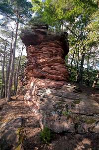 |  |  |
Rindsberg Westpfeiler has a quite typical structure: it is what is called a massif - a cliff connected to the mountain in its back - and rectangular lines dominate. To the south, a leaning pillar is located in front of the massif and it is here on the pillar that the most popular climbs are located. Pfeilerweg, a 5+ route makes use of the crack between pillar and massif and is known as one of the most popular crack climbs of the region.
Most routes, however, run through the west face of the massif and thanks to an overhanging roof right on top of the face their difficulties range in the 7- - 8+ region. They are most often climbed during early Spring or late autumn, when the face is not as exposed to the sun anymore as during the summer. Horizontal ledges, which run through the face offer perfect belay positions and most routes are protected by numerous bolts. The top of the cliff carries a ridge of mushroom like boulders among which quite often peregrines and eagle owls build their nests. Therefore it is not uncommon that Westpfeiler is closed for climbing during the first half of each year.
Climbing Routes on Westpfeiler
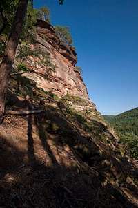
 Climbing action on the south and west faces
Rindsberg Westpfeiler is the most popular climbing crag in the closer area. It has routes of all qualities and dificulties with about a handful of "classics". Like its neighbours the rock was discovered pretty late for climbing and the first documented routes went up in 1953. On the other hand, even in 2007 several new routes went up so that there definitely is some potential left. The classics are called Albatros 7-, Bergweg 6+, Dying Akku 7- and Butterfinger 7-.
The following information is linked from the site of the Vereinigung Pfälzer Kletterer I link to their routes database directly with some summary info. Here is the link to the complete database.
| Region | Routes link | Summary |
| Rindsberg Westpfeiler | Westpfeiler | 19 routes with variations ranging from 5 - 8+ |
Getting There
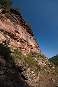
 Rindsberg Westpfeiler seen from Kleine Weiherwand
The cliffs on Rindsberg can be reached from the village of Spirkelbach. It can be most easily reached from the main highway B10, exit Wilgartswiesen. Follow the signs to Spirkelbach once you are in the centre of Wilgartswiesen (small hidden road).
The closest airports are at Frankfurt and Stuttgart so the itineraries start there too.
From Frankfurt
There are two possible routes which both take equally long- Via Ludwigshafen
- From Frankfurt take motorway A5 southward to Darmstadt.
- There change to A67 south.
- At Viernheimer Dreieck turn onto A6 west. Leav
- e it at Frankenthaler Kreuz for A61 south.
- At Mutterstädter Kreuz take A65 south until you reach Landau.
- At Landau turn on B10 west.
- Leave B10 at Wilgartswiesen and drive into the village
- Right in the center K54 turns off south in the direction of Spirkelbach
- Drive through the village, direction Sarnstall. Right after the end of the village there is a big parking lot to the left of the road. You need to hike for about 10 minutes to the east.
- Via Kaiserslautern
- From Frankfurt take motorway A3 west
- At Mönchhofdreieck turn onto A67 south
- At Rüsselsheimer Dreieck take A60 west
- At Kreuz Mainz Süd take A63 south
- At Kreuz Kaiserslautern turn onto A6 west
- At Kreuz Landstuhl turn onto A62 south
- At Pirmasens turn onto B10 east
- At Wilgartswiesen turn off and follow the instructions above
From Stuttgart
- Take motorway A8 to Karlsruhe
- At Karlsruher Dreieck turn north onto A5
- Tke the next exit to head for A65
- At Landau North turn to B10
- Rest as above
Red Tape
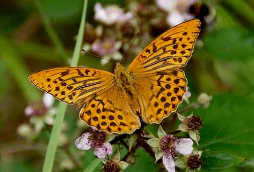 Argynnis paphia
Yes, there is red tape and lots of it. The sandstone of Südpfalz forms lots of caves and overhangs. Though this makes it most interesting for climbers, two species of birds of prey compete for this habitat: the peregrine falcons and the eagle owls. Both are endangered and wherever there is a eagle owl pair found nesting in the sandstone the crag will immediately be closed. Generally this closure lasts from the beginning of each year through Aug. 1st. If breeding is not successful the closures will be cancelled even before that date. For a list of closures see the Closure List of PK.
The cliffs on the south side of Rindsberg are rather often closed to climbing. Never all of them so you should check the link above before venturing out in the first half of the year.
The use of magnesia is not allowed in the whole Südpfalz region. This is rather a directive or an arrangement than an outright law. Thus you probably will get away with using it but do so only when absolutely necessary. Magnesia closes the pores which you find in the sandstone and together they form a smooth surface which will get very slippery in wet conditions. The rule of thumb is to use magnesia in the highest difficulty sections and only extremely sparingly.
A list of guidelines can be found here (in German).
Accommodation
You can find hotels and apartments in Wilgartswiesen or neighbouring Rinnthal and Hauenstein. Have a look at the following links (which are in German, however):- Wilgartswiesen information
- Trifelsland information
- Hauenstein Pfalz information
- Hauenstein information
- Rinnthal information
Weather Conditions
Maps & Books
Maps
As for maps there is a good overview map (1:50000) by Kompass Verlag but the best ones are the official topographic maps by the state government of Rheinland Pfalz, scaled 1:50000, 1:25000 and 1:5000. All official maps can be found on the web page of Landesvermessungsamt Rheinland Pfalz
1:50000
- Naturpark Pfälzer Wald
Kompass Map WK766
ISBN: 3-85491-523-3
- Annweiler am Trifels
LVA RLP Map L6712
ISBN: 3-89637-191-6
1:25000
- Annweiler am Trifels
LVA RLP Map 6713
ISBN: 3-89637-141-X
Books
There are a number of climbing guidebooks on the region of Südpfalz. The best ones, however, have been published privately and are sold only in selected bookshops of the region.
- Hiking
- Pfälzerwald
B. & J.-Th. Titz
Rother Verlag
ISBN: 3-7633-4268-0 - Klettern im Buntsandstein
U. Daigger, H.-J. Cron
Westpfälzische Verlagsdruckerei St. Ingbert
ISBN: 3-00-0155457-4
- Pfalz - Klettern im Buntsandstein des Pfälzer Felsenlands
J. Richter, S. Tittel
Panico Alpinverlag
ISBN: 978-3-936740-41-7
- Pfalz ++, Klettern im Buntsandstein
R. Burkard, P. Weinrich
Published privately
- Klettern im Naturpark Pfälzerwald
Naturfreunde Lambrecht
Published privately - Pfalz & Nordvogesen en bloc
A. Wenner, Y. Corby, I. Bald
Panico Verlag
ISBN: 3-936740-19-4
  Climbing Guidebook |
Climbing