
-
 6396 Hits
-
 81.73% Score
-
 14 Votes
|
|
Mountain/Rock |
|---|---|
|
|
49.16046°N / 7.70450°E |
|
|
Sport Climbing |
|
|
Spring, Summer |
|
|
1050 ft / 320 m |
|
|
Overview
 Salzwooger Teufelstisch Seen from Ostgratfels in winter Salzwooger Teufelstisch Seen from Ostgratfels in winter |
Runder Hut, Drachenfels, Hexenpilz and Felsentisch - there are many names for the mushroom like sandstone formations you can find in the Südpfalz climbing area. Many of the names involve witches, devils, dragons, which - after medieval lore - erected the rocks. What couldn't be explained had to be of some higher - or rather lower - origin. The best known formation is Kaltenbacher Teufelstisch, a square tabletop, balanced on three fragile looking pillars.
 |  | 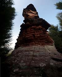 |  |
Quite close - only a couple of km to the south-west of Kaltenbacher Teufelsfels there is a second "Devil's Table": Salzwooger Teufelstisch, named after a nearby hamlet. Like its famous namesake it is a standalone rock with a broad top, overhanging on all sides. Here the similarities end, however. Instead of the three fragile pillars the Salzwoog formation has one broad round one and the top is everything but square. Depending on the direction you look at it it resembles a snake head or a butterfly. From the east you might even imagine a question mark ...
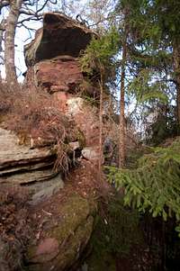
The formation is located on a high ridge above Salzwoog, which is densely covered by a pine and fir forest. Consequently getting there is a bit tricky and I must confess that I went wrong twice both times I visited Teufelstisch. The tower is the highest formation on a long sandstone crest, which stands out a little from the mountain ridge it is placed on. Most of the rocks on this crest are of no importance but directly beside Teufelstisch, located to its east there is a second cliff on which routes have been established, simply called Ostgratfels (East Ridge Rock). It has two easy normal routes and two difficult aid routes on its south face. The latter most probably have never been freed because of the dense fir forest, which protects its approach.
 |  |  |  |
Salzwooger Teufelstisch, on the other hand, has more routes, all of which have been freed. The normal route is a UIAA 5 affair but there is a variation which reaches 8+. The overhangs, obviously, are the cruxes of the routes. Almost all routes run through the north face, by far the highest face of the formation. Salzwooger Teufelstisch is quite unknown, the approach is long compared to most of the other Südpfalz cliffs so that you will never have to compete for routes with others. An occasional hiker may visit but since the formation is not on any of the marked hiking routes this occurrence will also be very rare.
Oh, for those who might have wondered: the names above translate to "Round Hat", "Dragon Rock", "Witches Mushroom" and "Rock Table".
Climbing Routes on Salzwooger Teufelsstisch
 Teufelstisch south face
Salzwooger Teufelstisch is a latecomer in the history of Südpfalz climbing. While most formations were first climbed in the first two decades of the 20th century, here the first routes were established in the 1980s, the heyday of sports climbing. Both formations, Teufelstisch and Ostgratfelsen, have several routes of varying difficulty.
The following table has a link to the tour database of the PK, where you can find the grades for the free routes plus additional information. Here is the link to the complete route database.
| Feature | Routes link | Summary |
| Salzwooger Teufelstisch | Salzwooger Teufelstisch | 7 routes with variations ranging from 4 - 8+ |
| Ostgratfelsen | Ostgratfelsen | 4 routes ranging from 1 - 4/A1 |
Getting There
Salzwooger Teufelstisch can be found on a ridge to the south-west of the village Salzwoog. For a brief period its top is visible from the nearby highway L486, where you also can find a small parking lot. In the end the formation is pretty well hidden in the midst of Pfälzerwald so that the itinerary is quite lengthy.From Frankfurt
There are two possible routes which both take equally long- Via Ludwigshafen
- From Frankfurt take motorway A5 southward to Darmstadt.
- There change to A67 south.
- At Viernheimer Dreieck turn onto A6 west.
- Leave it at Frankenthaler Kreuz for A61 south.
- At Mutterstädter Kreuz take A65 south until you reach Landau.
- At Landau turn on B10 west.
- After you passed Hinterweidental turn onto 487 which takes you to Salzwoog.
- Here turn onto L487 for a couple of hundred metres. At the next intersection you'll find a parking lot to the right.
- From here cross L487, then L485 to get to the opposite side of the intersection.
- Take the combined hike/bike route along L485 south-westwards
- After 500m turn onto a dirt road to the left
- After 200m turn left onto another bike route (direction Salzwoog)
- It crosses a creek after which a sign to "TTeufelstisch" leads you to the left up a mountain slope
- On top of the slope, at a crossing, the next sign turns left again
- After 100m a hidden sign leads you right, on an extremely steep path towards Teufelstisch
- Via Kaiserslautern
- From Frankfurt take motorway A3 west
- At Mönchhofdreieck turn onto A67 south
- At Rüsselsheimer Dreieck take A60 west
- At Kreuz Mainz Süd take A63 south
- At Kreuz Kaiserslautern turn onto A6 west
- At Kreuz Landstuhl turn onto A62 south
- At Pirmasens turn onto B10 east
- Right before Hinterweidental turn onto L487, then follow the instructions above
From Stuttgart
- Take motorway A8 to Karlsruhe
- At Karlsruher Dreieck turn north onto A5
- Take the next exit to head for A65
- At Kandel you can leave onto B427 which will lead you directly to Dahn. However the detour to Landau and B10 will take less time as the roads are better (three or four lanes).
- After Hinterweidental take L487, then follow the instructions above
Red Tape
Yes, there is red tape and lots of it. The sandstone of Südpfalz forms lots of caves and overhangs. Though this makes it most interesting for climbers, two species of birds of prey compete for this habitat: the peregrine falcons and the eagle owls. Both are endangered and wherever there is a eagle owl pair found nesting in the sandstone the crag will immediately be closed. Generally this closure lasts from the beginning of each year through Aug. 1st. If breeding is not successful the closures will be cancelled even before that date. For a list of closures see the Closure List of PK. The Schillerfelsen are so close to the nearest houses of Dahn, that usually birds don't nest there. However, please adhere to "stop signs" if there are any.The use of magnesia is not allowed in the whole Südpfalz region. This is rather a directive or an arrangement than an outright law. Thus you probably will get away with using it but do so only when absolutely necessary. Magnesia closes the pores which you find in the sandstone and together they form a smooth surface which will get very slippery in wet conditions. The rule of thumb is to use magnesia in the highest difficulty sections and only extremely sparingly.
A list of guidelines can be found here (in German).
Parking: The parking lot closest to Teufelstisch are charged. There is a children's playground nearby which also costs some bucks.
Accommodation
Don't look for accommodation in Salzwoog itself. There might be an inn or two but that's certainly all. A few kilometres to the south-east, however, at Dahn, you can find everything that you need. See the following link:Dahn tourist information site
Dahn has a youth hostel and several campgrounds. The closest one is between Slzwoog and Dahn at Neudahner Weiher.
Weather Conditions
Maps & Books
Maps
As for maps there is a good overview map (1:50000) by Kompass Verlag but the best ones are the official topographic maps by the state government of Rheinland Pfalz, scaled 1:50000, 1:25000 and 1:5000. All official maps can be found on the web page of Landesvermessungsamt Rheinland Pfalz
1:50000
- Naturpark Pfälzer Wald
Kompass Map WK766
ISBN: 3-85491-523-3
- Pirmasens Süd<
LVA RLP Map L6910
ISBN: 3-89637-193-2
1:25000
- Dahn
LVA RLP Map 6812
ISBN: 3-89637-147-9
Books
There are a number of climbing guidebooks on the region of Südpfalz. The best ones, however, have been published privately and are sold only in selected bookshops of the region.
- Hiking
- Pfälzerwald
B. & J.-Th. Titz
Rother Verlag
ISBN: 3-7633-4268-0 - Klettern im Buntsandstein
U. Daigger, H.-J. Cron
Westpfälzische Verlagsdruckerei St. Ingbert
ISBN: 3-00-0155457-4
- Pfalz - Klettern im Buntsandstein des Pfälzer Felsenlands
J. Richter, S. Tittel
Panico Alpinverlag
ISBN: 978-3-936740-41-7
- Pfalz ++, Klettern im Buntsandstein
R. Burkard, P. Weinrich
Published privately
- Klettern im Naturpark Pfälzerwald
Naturfreunde Lambrecht
Published privately - Pfalz & Nordvogesen en bloc
A. Wenner, Y. Corby, I. Bald
Panico Verlag
ISBN: 3-936740-19-4
  Climbing Guidebook |
Climbing