
-
 38697 Hits
-
 90.81% Score
-
 33 Votes
|
|
Mountain/Rock |
|---|---|
|
|
32.37590°N / 110.8554°W |
|
|
Hiking, Scrambling |
|
|
Spring, Summer, Fall, Winter |
|
|
7468 ft / 2276 m |
|
|
Overview
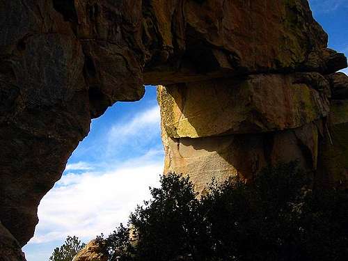
The Window | Falsberg
Ventana Canyon is arguably the most beautiful of the canyons adorning the ‘front range’ of the Santa Catalina Mountains north of Tucson. The name Ventana (meaning ‘window’ in Spanish) refers to the unique rock formation located at the top of the drainage. Here a large natural arch opens in the middle of a cliff with views of Tucson. The namesake window is easily approached from its back side, but requires a formidable 6.5 - 7 mile | 4450 feet vertical approach from the canyon entrance.
Slightly beyond the window lies Window Peak, within the top 500 highest peaks in Arizona. At 7,456 feet it is the second highest point on the front range, though still significantly lower than the 9,157’ summit of Mt. Lemmon, the broad highpoint of the range that lies farther north. Window Peak is a dramatic collection of rock spires that tops out the divide between the Ventana and Esperero drainages and requires a short bit of class 3 chimney climbing to reach its summit. The route to the actual summit is not marked but a slight diversion from the trail will take you there. A summit register once awaited the visitor with a sign reading ‘good job you crazy bastard.’ The register has since been removed, a common practice recently in Southern Arizona.
The hike to the summit of Window Peak is challenging, and the finish scramble can be a bit interesting in icy conditions, yet the walk through breathtaking canyon scenery makes this one of the most rewarding hikes in the Tucson area. Close to town, this summit can easily be attained in a solid day of hiking.
Call the Santa Catalina Ranger District at 520-749-8700 for the latest conditions.
![Maiden Pools - 2.4 mi from...]() Maiden Pools in Ventana Canyon | Falsberg
Maiden Pools in Ventana Canyon | Falsberg
Backcountry Camping
From the Santa Catalina Ranger District website: “The steep, rocky terrain of the Coronado National Forest provides a limited number of flat areas suited to camping. As a result, many of the campsites are used repeatedly and show the signs of human activity. However, campers are encouraged to use these existing sites (instead of creating new campsites) when possible to limit the expansion of newly impacted sites. When camping in a remote area with no existing sites, select an area with a sandy surface, or one covered with thick leaf or needle cover and without vegetation. Always avoid camping near water, in meadows or near cliffs and rockslides since these areas are important to wildlife.” There are a few existing camp spots in Ventana Canyon and above at the saddle below Window Peak.
National Forest Campgrounds
There are no campgrounds immediately near the Sabino Canyon Recreation Area nor near the Ventana Canyon Trailhead. The Santa Catalina Ranger District operates several campgrounds along the Santa Catalina Highway en route to Mount Lemmon. These are (in distance up the highway from the valley):
• Molino Campground
• General Hitchcock Campground
• Rose Canyon Lake
Resorts
If you're the type who likes to kick back after a hike in luxury, check out the Ventana Canyon Resort. You could walk from your suite directly to the Ventana Canyon Trailhead, which ajoins the parking lot for resort staff.
![A strangely shaped tower near...]() Towers near the summit
Towers near the summit
Trip reports about the ascent of Window Peak:
• SummitHut
• Hike Arizona
• Sierra Club
| Rank: 498th highest peak in Arizona Prominence: 768 feet USGS Quad: Mount Lemmon Planning Map: Green Trails Maps 2886S | Santa Catalina Mountains YDS Rating: Class 3 Peak Statistics: Lists of John Special Note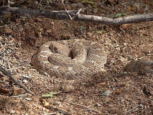 A coiled diamondback rattlesnake near the mouth of Ventana Canyon | Falsberg  Sunset on the walls of Sabino Canyon Sunset on the walls of Sabino CanyonGetting There & Route Overview Sunset and moonrise on Esperero Canyon Sunset and moonrise on Esperero CanyonWindow Peak is very close to the southern Arizona city of Tucson and can be easily accessed via suburban trailheads (paved access). ROUTES There are two primary routes to the summit of Window Peak:
TRAILHEADS Here are the two primary trailheads used to access Window Peak:
Red Tape
|

Weather & Seasons
| *A trip to this summit would be most pleasant in spring or fall. *Recent snowfall in the winter can make the final summit pitch icy. *March and April are primo wildflower viewing months. *Summer temperatures in this part of the Sonoran desert can be worse than uncomfortable; they can be downright dangerous! *According to the United States National Weather Service, the record high temperature for Tucson, Arizona, set on 26th June 1990, was 117 degrees Farenheit / 47 degrees Celsius. 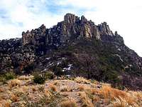 Window Peak Window Peak |  Old summit cairn Old summit cairn |

Camping
 Maiden Pools in Ventana Canyon | Falsberg
Backcountry Camping
From the Santa Catalina Ranger District website: “The steep, rocky terrain of the Coronado National Forest provides a limited number of flat areas suited to camping. As a result, many of the campsites are used repeatedly and show the signs of human activity. However, campers are encouraged to use these existing sites (instead of creating new campsites) when possible to limit the expansion of newly impacted sites. When camping in a remote area with no existing sites, select an area with a sandy surface, or one covered with thick leaf or needle cover and without vegetation. Always avoid camping near water, in meadows or near cliffs and rockslides since these areas are important to wildlife.” There are a few existing camp spots in Ventana Canyon and above at the saddle below Window Peak.
National Forest Campgrounds
There are no campgrounds immediately near the Sabino Canyon Recreation Area nor near the Ventana Canyon Trailhead. The Santa Catalina Ranger District operates several campgrounds along the Santa Catalina Highway en route to Mount Lemmon. These are (in distance up the highway from the valley):
• Molino Campground
• General Hitchcock Campground
• Rose Canyon Lake
Resorts
If you're the type who likes to kick back after a hike in luxury, check out the Ventana Canyon Resort. You could walk from your suite directly to the Ventana Canyon Trailhead, which ajoins the parking lot for resort staff.
External Links - Trip Reports
 Towers near the summit
Trip reports about the ascent of Window Peak:
• SummitHut
• Hike Arizona
• Sierra Club