
-
 10800 Hits
-
 84.27% Score
-
 18 Votes
|
|
Mountain/Rock |
|---|---|
|
|
47.33276°N / 11.23757°E |
|
|
Hiking, Skiing |
|
|
Spring, Summer, Fall, Winter |
|
|
7287 ft / 2221 m |
|
|
Overview
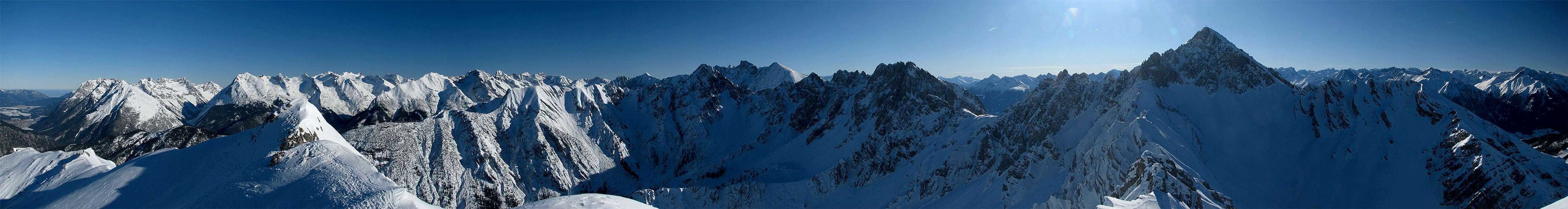
 Summit view
But such an impressive panorama has its negative sides. A cable car leading up to Seefelder Joch saves almost to hole ascent and the remaining ridge walk is done by many people during the summer and autumn months. During winter the cable car is part of the skiarea Rosshütte, but after leaving Seefelder Joch the crowds stay behind. Quite in contrast to that is a stay at Nördlinger hut (not far away), which offers the possibility to stay on the summit after the crowds went down with the last cable car.
Summiting Seefelder Spitze doesn' t contain any difficulties during summer. There are some iron cable protections along the ridge, which aren' t needed. During winter the final ridge to the summit offers a bit more fun. But except of some cornices (which may get quite big at some places) it is still easy going.
Cumming it all up leasd to the result that Seefelder Spitze is a mountain with an exceptional panorama with all pros and cons. I' ve been there more than once now and I enjoyed every time!
Panoramic Views
 | ||
|

Visit http://www.alpen-panoramen.de/panorama.php?pid=5351 for a version of the "Winterly Karwendel" panorama with named mountains. To show the mountain names you have to click on the "Übersicht ein/aus" button below the panorama.
Maps And Routes Overview
 Reitherkar
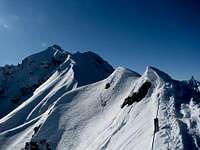 On the ridge
Maps:
- KOMPASS #26 - Karwendelgebirge
Good overview map of the hole Karwendel. For hiking porpuses this map is sufficient (scale 1:50000). The map can be bought at www.amazon.de or at KOMPASS. - Alpenvereinskarte 5/1 Karwendelgebirge, West
More detailed map (1:25000) of the western part of Karwendel
Routes:
There are various possibilities of getting up to Seefelder Spitze, but I' ll only list the two most popular ones:- Via Seefelder Joch
Starting at Seefeld (parking lot of Rosshütte calbe car) at trail leads up the skiarea or you choose the trail along the Hermannstal valley. Both trails join at Rosshütte and lead on the final steeper slope to Seefelder Joch (2050m/6726ft). From there simply follow the ridge for about 1km to the summit. There are some iron cables on the ridge, which aren' t really needed. Since the cable car runs up to Seefelder Joch you won' t be along here. During the winter months the ridge isn' t that crowded since most people stay within the skiarea.
The route along the skiarea is the common winter ascent, but be aware of cornices on the ridge every here and there! - From Reitherkar (also called Härmeleskar)
There are two possibilies to get to the Reitherkar. Either from Seefeld along the souther part of the skiarea via Härmelerkopf (2224m/7297ft) or from the trailhead of Reither Spitze via Nördlingerhut. After reaching the Reitherkar a trail crosses it leading up to the south ridge. There are some iron wires for protection (not really needed).
Mountain Conditions
 It may be stormy on the ridge...
Weather:
- www.wetter.at
Long term forecast for the Seefeld (www.wetter.at). - ZAMG
Quite precise forecast for the next three days for Tyrol. I haven' t seen this forecast being false the last years... - OEAV weather forecast
Weather forecast especially for mountaineering porpuses. Unfortunately this page is available in german only. - Avalanche report (Tyrol/Austria)
There is a link to a .pdf file download on the left side of the page, which contains the english translation.
Webcams:
- http://waldhotel-seefeld.at/Webcam/webcam.html
Webcam at Seefeld looking up to Roßhütte (1751m/5745ft).
Getting There
There are two major trailsheads for Seefelder Spitze. The first is Seefeld which is easily reachable by train and car. The second one is the parking lot close to the Maximilianshütte between Seefeld and Auland, one of the trailheads of Reither Spitze. The last one is not directly rechable by public transportation.By car:
To reach one of the trailheads, you have to get to the area of Seefeld, which is reachable via road 177 and B2 which connect Innsbruck (Austria) and Garmisch-Partenkirchen (Germany). From Garmisch-Partenkirchen you have a highway connection to Munich. Innsbruck provides a highway conenction to Italy (Brenner) and Switzerland (Arlberg).By train:
If you go to Reither Spitze by train your trailhead is either the train station at Seefeld or Scharnitz. About every two hours the train from Garmisch-Partenkirchen (Germany) to Innsburck (Austria) stops there. From Garmisch-Partenkirchen you have access to the trains to Munich, Ehrwald (Austria) and Rheutte (Austria). Innsbruck is the gateway to Italy (Bozen/Bolzano, Verona).
For more information visit the homepage of Deutsche Bahn for german and ÖBB for austrian train connections. To get to the trails up to Seefelder Spitze from the trainstation at Seefeld you have to follow the signs to Roßhütte.
Red Tape
There are no permits, fees or seasonal closures.There is a parking lot at the valley station of the cable car running up to Roßhütte (1751m/5745ft), which is not free of charge if you don' t use the cable car...
Seefelder Spitze is located at the border of the nature reservation area Karwendel and therefore it is forbidden to camp on the mountain. Additionally you shouldn' t pick up flowers and don' t leave anything but footprints. Well, because of the popularity of the mountain, there is a lot of litter on the way. Please help that this doesn' t become worse...
Camping
Seefeld is a touristic area with tons of hotels and places to stay. For more information visit the multilangual homepage of the area. Innsbruck and Garmisch-Partenkirchen aren' t far away as well.Because of the nature reservation area Karwendel, camping on the mountain is forbidden. Additionally you should carry everything back down and leave only footprints. If you like to stay on the mountain Nördlinger hut (2239m/7346ft) is the closest hut.
When To Climb
| Seefelder Spitze is climbed all the year. During the winter months, the ascent via the skiarea is very popular. But since the final slope is fairly steep a look at the avalanche report of Tyrol isn' t a bad thing. If the avalanche situation is not safe enough you still can ascend to Seefelder Joch (2050m/6726ft), which isn' t threatened by avalanches at all (top of the skiarea). | 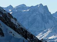 Winterly ascent Winterly ascent |
External Links
- www.seefeld.at
Multilangual homepage of the area around Seefeld. - www.karwendel.org
Homepage of the nature reservation area Karwendel. - members.chello.at/noerdlingerhuette
Homepage of the Nördlinger hut on the slopes of Reither Spitze.