
|
|
Mountain/Rock |
|---|---|
|
|
44.00080°N / 71.536°W |
|
|
4340 ft / 1323 m |
|
|
Overview
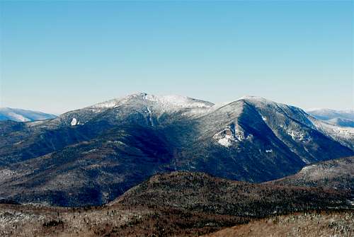
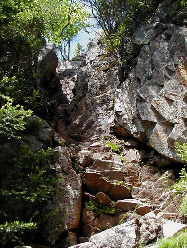
Mount Osceola (4340') Mount Osceola is among one the most climbed mountains in the Southern White Mountains. Though Mt. Osceola never reaches timberline, the two views from the summit are spectacular. On any given clear, high visibility day you can see forty one of the of the other 4000's in New Hampshire and even faintly see Mt. Mansfield towards the west. Mount Osceola is also famous because it is very easy to summit, especially from the Waterville Valley . The Class 1 Mt. Osceola Trail from the southwest never truely goes beyond a moderate grade from the Waterville Valley and only rises 2,060' in a 6.4 mile round trip hike. Though not quite as gentle as Mt. Garfield to ascend, Mt. Osceola is usually one the first mountains to be climbed by a 4000' peakbagger. From the East though this climb can be very tough. At time the trail here can become Class 2 especially on part of the way up East Osceola and a section of the trail called the chimney between East Osceola and Mount Osceola.
East Osceola (4,156') is the less famous neighbor of Mount Osceola. It is famous for its view of nothing but trees, though there are views just a little ways from East Osceola. Due to the fact that is harder to get to and that is no special view, most hikers and peakbaggers go over the mountain just as a side trip from Mt. Osceola.
 |
 |
 |
 |
 |
Getting There
MT. OSCEOLA TRAILHEAD VIA TRIPOLI ROAD: (2280') This road is usually closed from November to April to snowmobile traffic. From I-93, get off on Exit 31 (Tripoli Road) and head east on Tripoli Road to past the trailhead on the Mount Tecumseh Trail. Mt. Osceola is 7 miles on your left (WMNF Mandatory Fee).
From Waterville Valley, head to the Waterville Ski Area. When you reach Tripoli Road make a right. When you come to a fork in the road, make another right. Head Past the Livermore Park Ranger Station and campground and all the way up Tripoli Road past the height of land. Mt. Osceola will be on your right just past the height of land.
KANCAMAGAS VIA GREELEY PONDS TRAILHEAD: Take I-93 to Exit 32. Take a left off the light at the exit ramp and stay on the Kancamgas Highway through the tourist town of Lincoln and past the Loon Ski Resort. continue past the trailhead to the East Pond Trail and until you begin up a switchback on the Kancamagus Highway. The Greenley Ponds Trailhead will be on your right.
Red Tape
WMNF Mandatory fee at both trailheads.
When To Climb
Mt. Osceola is usually climbed in summer and fall due to road access and the mud and black fly season in spring. Often though many people at a time will be on top of Mt. Osceola on summer weekends. During this time of year, Mt. Osceola would be best for new peakbaggers trying to get a taste of the 4000 footer's in the White Mountains
However Mt. Osceola can be climbed at all seasons. From Tripoli Road this hike though is dramatically extended in winter due to the closing of the road. Even with the closing of the Tripoli Road in winter this side can be climb by aid of only snowshoes due to its easy to moderate slope, although very long. From the east though crampons are very strongly advised due to a number of very steep sections on the trail.
Camping
Mt. Osceola can be easily done in day so there is little reason to camp while hiking the mountain. However if you like to do backcountry camping check out the Backcountry Camping Rules in the AMC White Mountain Guide (See Books).
There are also camping areas along Tripoli Road that only require a permit from Livermore Ranger Station and Livermore Camping Area nearby..
Mountain Conditions
Here are two websites that will provided you the best information on conditions in the White Mountains.
Appalachian Mountain Club
Current Trail Conditions
Also drop by the Livermore Park Ranger station in Waterville Valley for more information.
Weather Conditions
Here is a link to a weather forecast for Higher Summits of the White Mountains .

Summit Picture Log
Post your summit mugshot here.
 |
 |
 |
 |