Overview
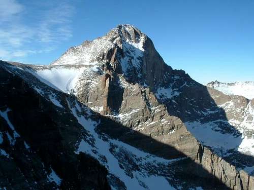
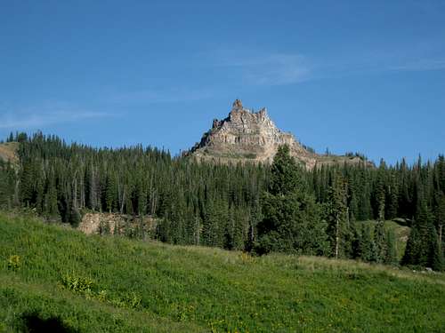
![1/21/05: Longs Peak, as seen...]() Longs Peak
Longs PeakColorado is one of the most beautiful states in the United States. This was one of the last major states on Summitpost not to have a page dedicated to its 2,000 foot prominence peaks. In the lower 48 Colorado ranks 7th. Nevada, California, Montana, Idaho, Utah, and Washington have more. Colorado is able to boast 80 P2K peaks and 2 Error Range peaks. Most avid hikers in Colorado are in competition to climb 14ers and 13ers. Only 20 of Colorado's 53 14ers have at least 2,000 feet of Prominence. As far as 13ers there are 18 with at least 2,000 feet of prominence. There is also 26 County High Points on this list as well.
There are some other pages on Summitpost dedicated to Prominent peaks in Colorado. I made this list to help Summitpost members and others who are insterested in focusing on Colorado's 2,000 foot prominent peaks. At the time of writing this 64 of the 82 peaks have Summitpost pages. Colorado gets a lot of new mountain pages on Summitpost on a monthly basis. I'm putting a goal out there for Summitpost members: for all of Colorado's P2Ks to have a Summitpost page by the end of 2012 (except Ute Peak, since it is on an Indian Reservation). There are some very avid Summitpost members posting pages in Colorado. Does this sound attainable?
I will be keeping an eye out to make this page stay as updated as possible.
Resources used to help with this page:
Peaklist and
Peakbagger.
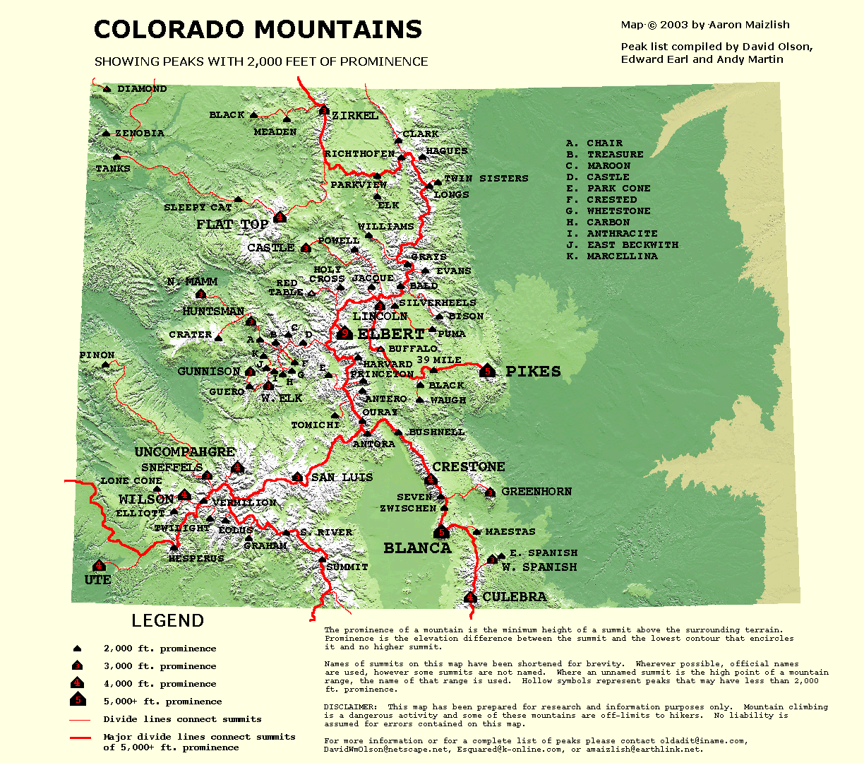
Here is a map of the Colorado P2Ks.
Colorado County Map
To date there is one known person who has climbed all of Colorado's Prominence Peaks:
Bob Packard To see the list of others progress on this list check out
Peakbagger.
Colorado's 2,000 foot Prominence Peaks
| Rank | Image | Summit Name | Elevation (ft) | Prominence (ft) | County | Latitude | Longitude | Map Link |
|---|
| 1 |  | Mount Elbert | 14,440 | 9,093 | Lake COHP | 39.117732N | 39.117732°W | Map |
| 2 |  | Pikes Peak | 14,115 | 5,530 | El Paso COHP | 38.840511°N | 105.044589°W | Map |
| 3 |  | Blanca Peak | 14,349 | 5,325 | Alamosa & Costilla COHPs | 37.577491°N | 117.088°W | Map |
| 4 |  | Culebra Peak | 14,047 | 4,827 | Costilla | 37.122357°N | 105.185805°W | Map |
| 5 |  | Crestone Peak | 14,294 | 4,554 | Saguache COHP | 37.966829°N | 105.585473°W | Map |
| 6 |  | Uncompahgre Peak | 14,309 | 4,249 | Hinsdale COHP | 38.071653°N | 107.462165°W | Map |
| 7 |  | Flat Top Mtn | 12,354 | 4,054 | Garfield COHP | 40.014759°N | 107.083357°W | Map |
| 8 |  | Ute Peak | 9,979 | 4,039 | Montezuma | 37.284032°N | 108.778622°W | Map |
| 9 |  | Mount Wilson | 14,246 | 4,026 | Dolores COHP | 37.839122°N | 107.991586°W | Map |
| 10 |  | Mt. Lincoln | 14,286 | 3,866 | Park COHP | 39.351504°N | 106.111584°W | Map |
| 11 |  | Greenhorn Mountain | 12,347 | 3,777 | Pueblo COHP | 37.881517°N | 105.013273°W | Map |
| 12 |  | West Spanish Peak | 13,626 | 3,686 | Huerfano, Las Animas COHP | 37.375588°N | 104.993396°W | Map |
| 13 |  | Mount Gunnison | 12,719 | 3,539 | Gunnison | 38.812095°N | 107.382599°W | Map |
| 14 |  | Mt. Zirkel | 12,180 | 3,470 | JacksonRoutt (Highest Point) | 40.831338°N | 106.663082°W | Map |
| 15 |  | San Luis Peak | 14,014 | 3,114 | Saguache | 37.98690°N | 106.9308°W | Map |
| 16 | | North Mamm Peak | 11,123 | 3,103 | Garfield | 39.38655°N | 107.866082°W | Map |
| 17 |  | West Elk Peak | 13,035 | 3,095 | Gunnison | 38.717882°N | 107.199441°W | Map |
| 18 | no SP Page | Huntsman Mountain | 11,852 | 3,072 | Gunnison & Pitkin | 39.192006°N | 107.366847°W | Map |
| 19 |  | Mount Sneffels | 14,150 | 3,050 | Ouray COHP | 38.003776°N | 107.79227°W | Map |
| 20 | | Castle Peak | 11,300 | 3,040 | Eagle | 39.773164°N | 106.834524°W | Map |
| 21 |  | Mt. Powell | 13,580 | 3,000 | Eagle & Summit | 39.76008°N | 106.340749°W | Map |
| 22 |  | Longs Peak | 14,255 | 2,955 | Boulder COHP | 40.254902°N | 105.616089°W | Map |
| 23 |  | Hesperus Mountain | 13,232 | 2,852 | Montezuma COHP | 37.445066°N | 108.088964°W | Map |
| 24 | | Diamond Peak | 9,660 | 2,845 | Moffat | 40.950447°N | 108.878173°W | Map |
| 25 |  | Treasure Mtn | 13,528 | 2,828 | Gunnison | 39.024375°N | 107.122762°W | Map |
| 26 |  | Clark Peak | 12,951 | 2,771 | Jackson COHP, Larimer | 40.606828°N | 105.930038°W | Map |
| 27 |  | Grays Peak | 14,270 | 2,770 | Clear Creek & Summit COHP | 39.633715°N | 105.817589°W | Map |
| 28 |  | Mt. Evans | 14,264 | 2,764 | Clear Creek | 39.588255°N | 105.64377°W | Map |
| 29 |  | Summit Peak | 13,300 | 2,760 | Archuleta COHP | 37.350649°N | 106.696947°W | Map |
| 30 |  | Marcellina Mountain | 11,348 | 2,728 | Gunnison | 38.929898°N | 107.243752°W | Map |
| 31 | | Mt. Richthofen | 12,940 | 2,680 | Grand & Jackson | 40.469546°N | 105.894522°W | Map |
| 32 | no SP Page | Piñon Mesa HP | 9,700 | 2,680 | Mesa | 38.825957°N | 108.771857°W | Map |
| 33 |  | Parkview Mtn. | 12,296 | 2,676 | Grand | 40.330237°N | 106.136233°W | Map |
| 34 |  | Mt. Ouray | 13,971 | 2,671 | Chaffee & Saguache | 38.422704°N | 106.224804°W | Map |
| 35 |  | Crested Butte | 12,162 | 2,582 | Gunnison | 38.883475°N | 106.943575°W | Map |
| 36 | no SP Page | Graham Peak | 12,531 | 2,551 | Hinsdale | 37.497219°N | 107.376179°W | Map |
| 37 |  | Mount Antero | 14,269 | 2,503 | Colorado | 38.673889°N | 106.246109°W | Map |
| 38 |  | East Beckwith Mountain | 12,432 | 2,492 | Gunnison | 38.846245°N° | 107.223168°W | Map |
| 39 |  | Chair Mountain | 12,721 | 2,461 | Gunnison | 39.05805°N | 107.282134°W | Map |
| 40 |  | Whetstone Mtn. | 12,516 | 2,456 | Gunnison | 38.822259°N | 106.979935°W | Map |
| 41 |  | Bison Peak | 12,431 | 2,451 | Park | 39.238486°N | 105.497643°W | Map |
| 42 |  | Black Mountain | 10,680 | 2,440 | Moffat COHP | 40.783508°N | 107.369068°W | Map |
| 43 |  | Mount Guero | 12,052 | 2,432 | Gunnison | 38.719621°N | 107.386137°W | Map |
| 44 |  | Hagues Peak | 13,560 | 2,420 | Larimer COHP | 40.484493°N | 105.646437°W | Map |
| 45 |  | South River Peak | 13,148 | 2,418 | Mineral | 37.574075°N | 106.981612°W | Map |
| 46 |  | Antora Peak | 13,269 | 2,409 | Saguache | 38.325016°N | 106.218017°W | Map |
| 47 |  | Bushnell Peak | 13,105 | 2,405 | Fremont COHP, Saguache | 38.341171°N | 105.889267°W | Map |
| 48 |  | Zenobia Peak | 9,005 | 2,395 | Moffat | 40.607211°N | 108.87006°W | Map |
| 49 |  | East Spanish Peak | 12,683 | 2,383 | Huerfano & Las Animas | 37.39351°N | 104.920163°W | Map |
| 50 |  | Castle Peak | 14,265 | 2,365 | Gunnison & Pitkin COHP | 39.00970°N | 106.8608°W | Map |
| 51 |  | Mount Harvard | 14,420 | 2,360 | Chaffee COHP | 38.924452°N | 106.320765°W | Map |
| 52 |  | Sleepy Cat Peak | 10,848 | 2,348 | Rio Blanco | 40.127524ºN | 107.533846ºW | Map |
| 53 |  | Twilight Peak | 13,158 | 2,338 | San Juan | 37.662989ºN | 107.727006ºW | Map |
| 54 |  | South Maroon Peak | 14,156 | 2,336 | Gunnison & Pitkin | 39.070789°N | 106.988972°W | Map |
| 55 | no SP Page | Tomichi Dome | 11,465 | 2,325 | Gunnison | 38.484916°N | 106.529058°W | Map |
| 56 | no SP Page | Waugh Mountain | 11,710 | 2,320 | Freemont | 38.602234°N | 105.695538°W | Map |
| 57 |  | Crater Peak | 11,327 | 2,307 | Delta | 39.039633ºN | 107.662813ºW | Map |
| 58 |  | Twin Sisters Peaks | 11,428 | 2,288 | Larimer | 40.28862ºN | 105.517453ºW | Map |
| 59 |  | Mt. Silverheels | 13,822 | 2,282 | Lincoln | 39.339346ºN | 106.005458ºW | Map |
| 60 |  | Lone Cone | 12,613 | 2,273 | Dolores & San Miguel | 37.888054ºN | 108.255573ºW | Map |
| 61 |  | Tanks Peak | 8,717 | 2,267 | Moffat | 40.425897ºN | 108.766008ºW | Map |
| 62 |  | Mount Zwischen | 12,006 | 2,266 | Huerfano | 37.791273ºN | 105.455381ºW | Map |
| 63 |  | Puma Peak | 11,570 | 2,260 | Park | 39.154187ºN | 105.584085ºW | Map |
| 64 | no SP Page | Elliot Peak | 12,340 | 2,240 | Dolores | 37.734391°N | 108.058047°W | Map |
| 65 | no SP Page | Black Mountain | 11,654 | 2,234 | Park | 38.718487ºN | 105.68736ºW | Map |
| 66 |  | Mount Mestas | 11,569 | 2,229 | Huerfano | 37.582969ºN | 105.147366ºW | Map |
| 67 |  | Mt. Eolus | 14,083 | 2,183 | La Plata | 37.621846°N | 107.622701°W | Map |
| 68 | no SP Page | Carbon Peak | 12,079 | 2,179 | Gunnison | 38.794276ºN | 107.043155ºW | Map |
| 69 |  | Meaden Peak (Sand Mtn) | 10,879 | 2,179 | Routt | 40.763613°N | 107.057508°W | Map |
| 70 |  | Mt. Princeton | 14,197 | 2,177 | Chaffee | 38.749127°N | 106.242337°W | Map |
| 71 |  | Elk Mountain | 11,419 | 2,159 | Grand | 40.161927°N | 106.128556°W | Map |
| 72 |  | Anthracite Range HP (Ohio Mountain) | 12,385 | 2,125 | Gunnison | 38.814526°N | 107.144505°W | Map |
| 73 |  | Mt. Holy Cross | 14,005 | 2,111 | Eagle COHP | 39.466697°N | 106.48172°W | Map |
| 74 |  | Vermilion Peak | 13,894 | 2,105 | San Juan COHP, San Miguel | 37.799333ºN | 107.828525ºW | Map |
| 75 |  | Bald Mountain | 13,684 | 2,104 | Summit | 39.444811ºN | 105.970535ºW | Map |
| 76 |  | 39 Mile Mtn (2 pts) | 11,548 | 2,088 | Park | 38.83244°N | 105.555332°W | Map |
| 77 |  | Jacque Peak | 13,205 | 2,065 | Summit | 39.454895ºN | 106.197038ºW | Map |
| 78 |  | Mt. Herard (Mt. Seven) | 13,340 | 2,040 | Saguache | 37.849152°N | 105.494903°W | Map |
| 79 | no SP Page | Park Cone | 12,100 | 2,040 | Gunnison | 38.796712ºN | 106.602847ºW | Map |
| 80 | no SP Page | Williams Peak | 11,617 | 2,037 | Grand & Summit | 39.877427ºN | 106.206514ºW | Map |
Error Range Peaks

| Rank | Image | Summit Name | Elevation (ft) | Prominence(ft) | County | Latitude | Longitude | Map Link |
|---|
| E1 | no SP Page | Red Table Mountain | 12,037 | 2,017 | Eagle | 39.418083ºN | 106.771218ºW | Map |
| E2 |  | West Buffalo Peak | 13,326 | 1,986 | Chaffee & Park | 38.991968ºN | 106.124573ºW | Map |
Weather Throughout Colorado

 15920 Hits
 83.69% Score
 17 Votes


Larry V - Aug 20, 2011 10:13 am - Voted 10/10
Summit PeakNice new page! Summit Peak (#29 on prominence list) is now back on SummitPost, after a long stint in purgatory.
redsplashman23 - Aug 20, 2011 12:37 pm - Hasn't voted
Re: Summit PeakGreat catch Larry. This is now fixed! Thanks for catching this.
aw11 - Nov 5, 2014 9:41 pm - Hasn't voted
Mount Mestas PageA page on Mount Mestas is now on SP. Add the link in your page?
redsplashman23 - Jan 25, 2015 10:26 pm - Hasn't voted
Re: Mount Mestas PageI added the link. Thanks for posting this page.
redsplashman23 - Nov 27, 2014 2:18 pm - Hasn't voted
thanksI added the link. Thanks for posting this page.
derekperc - Jan 23, 2015 6:48 pm - Hasn't voted
San Luis Peak#15 links to the correct page but the county and coordinates are for a peak in Nevada
redsplashman23 - Jan 25, 2015 10:25 pm - Hasn't voted
Re: San Luis PeakThanks for catching this. It's corrected.