
-
 11594 Hits
-
 86.37% Score
-
 22 Votes
|
|
Mountain/Rock |
|---|---|
|
|
39.12200°N / 106.2061°W |
|
|
Lake County |
|
|
Hiking |
|
|
Spring, Summer, Fall, Winter |
|
|
12892 ft / 3929 m |
|
|
Overview
 Stimpy on a frozen marsh
South Peak offers up some serious views. Occupying a fine piece of real estate on the west side of Weston Pass, the vistas of the Sawatch Range are awesome, but that’s only the obvious beginning. The views are strong from the Gore Range to the north all the way to the Sangre de Cristos to the south. Fellow Mosquito Range peaks, the twin Thirteeners East Buffalo Peak and West Buffalo Peak, show off in up-close-and-personal splendor.
A high Twelver sitting snugly within the top 800 peaks in Colorado, South Peak is readily accessible from Weston Pass and the summit can be attained via easy Class 1+ off-trail. But the scenery dashing across every horizon from the summit of this mellow mountain makes every step to the top of this the easy-to-reach walk-up well-worth the effort. And with nearly 1,000 feet of vertical prominence, this peak earns the right to a self-named USGS quad.
Rank: 721st highest peak in Colorado
Prominence: 952 feet
USGS Quad: South Peak
Planning Map: Trails Illustrated #110 Leadville/Fairplay
Rank & Prominence: Lists of John
Getting There
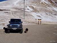 Parking in Weston Pass
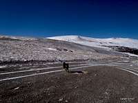 Crossing Weston Pass Road
 Sastrugi
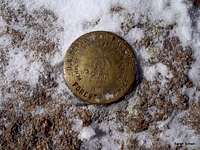 USGS Marker, South Peak
South Peak is in Lake County just north of the Park County line, about one mile as the crow flies from the summit of Weston Pass. The peak is accessible from the east via Highway 285 (passenger car accessible) and from the west via Highway 24 (high clearance recommended). This mountain is readily accessible via Weston Pass Road out of Weston Pass.
From Fairplay
When dry, this route is suitable for all passenger cars. | From Leadville
This route is best suited to high-clearance vehicles only. 4x4 strongly recommended. |
Red Tape
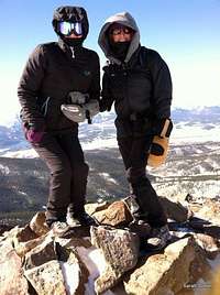 Single Digit Summit
From Weston Pass
The Weston Pass summit area appears to be covered by a private mine holding. No signage indicate the area off either side of the road is off limits to public use and the pass area hosts plenty of visitors through the public right-of-way. Recently a landowner has built a small hunting cabin near the pass on the west side. Please stay away from the cabin and provide the owners/occupants privacy and space.
 Sawatch Range Sawatch Range | 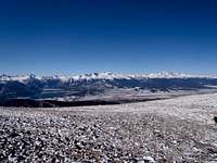 Elbert & Massive Elbert & Massive |  Southward Southward |  Mosquito Range Mosquito Range |
Camping & Lodging
 Mount Elbert
 Mount Massive
Designated National Forest Service Sites
The conveniently located Weston Pass campground which, despite the name, actually sits about 4 miles southeast of Weston Pass, is the closest campground for a Weston Pass approach.
Weston Pass Campground:
• 14 sites
• No reservations (first come, first served)
• $12.00 per night
• Elevation: 10,200 ft.
Hotels, Cabins & B&Bs
Fairplay & Alma
On the east side of Weston Pass, the communities of Fairplay and Alma provide a pleasant, laid-back atmosphere and reasonable prices for lodging. Not many hotel rooms and lodges exist on this side of the pass, but privately-owned rental cabins can allow for ample privacy with all of the comforts of home.
Detailed information about lodging in Fairplay and Alma may be found here: South Park Area Lodging
Buena Vista
Across Weston Pass on the west side is the relaxing town of Buena Vista (pronounced “Byoona-Vistah” by the locals). This friendly town provides several hotels and a few descent, casual restaurants. Prices are generally reasonable though rooms fill up fast as this is the gateway town for numerous Sawatch Fourteeners.
Detailed information about lodging in Buena Vista may be found here: Buena Vista Lodging
Leadville/Twin Lakes
The Leadville/Twin Lakes area provides simple down-to-earth, budget-friendly lodging option, including family RV parks. Still, proximately to several attractions, including Colorado’s High Point (Mount Elbert 14,433 ft.) mean snagging a room requires careful planning in advance of your visit.
For detailed information about lodging in the Leadville/Twin Lakes area, visit this website: Leadville Lodging
Weather & Seasons
 Click for weather forecast | Summer Summer allows for the most reliable access to South Peak from Weston Pass or possibly points to the west. The wildflowers covering the slopes of South Peak are sure to please. Fall Until the first deep snows fall, autumn allows for ready access to South Peak, though high winds and cold temperatures high on the ridge could make this an unpleasant outing. Winter Weston Pass is closed in snow season, guarding South Peak behind either a long approach from the highest available parking on Weston Pass Road or a long, cold, windy slog from the west. Spring A western approach in soft spring snow would be a lesson in postholing. The Weston Pass route is not readily accessible until the snows have thawed, the road has dried and the county sees it fit to open the pass. |  Click for weather forecast |
 Sawatch Range Sawatch Range |  Northward Northward |  Southward Sawatch Southward Sawatch |  Buffalo Peaks Buffalo Peaks |
Links to External Trip Reports
• 20-mile multi-peak link-up by Brian Kalet (SP Member)• South Peak Trip Report by Colorado Guy
• Slideshow Trip Report by Joe and Frede