
|
|
Mountain/Rock |
|---|---|
|
|
44.42000°N / 15.32000°E |
|
|
Hiking, Sport Climbing |
|
|
Spring, Summer, Fall, Winter |
|
|
4163 ft / 1269 m |
|
|
Google Earth
Since Google has blessed us with its magical Google Earth software you can visit any corner of the world from the chair parked in front of your computer. Thankfully Velebit is amazingly clear so you can discover its corners and see for yourself how it looks from the above and where are the places this page is dedicated to.Each geographical point of interest described on this page has coordinates on the top of its section. You can use these coordinates with Google Earth’s fly to search engine. Just copy the coordinates (like it is written, with coma) and paste them into fly to tab and press enter. And, of course, enjoy the flight!
Intro
 Stapina (1125m) from Cankove Njivice Stapina (1125m) from Cankove Njivice |
Hidden between picturesque white limestone cliffs of first step, on the seaboard side of South Velebit, lies Stap, small karst field, one of most romantic on whole Velebit. It is surrounded by very special area, which is also theme of this page, placed half way from the sea to the highest peaks streak which stands above the continental side of the mountain. This is not a place for peak baggers as there are no imposing peaks around. Those that seek beautiful nature should not avoid Stap. Imagine an area with so many unusual rock forms such as towers, bridges, windows, smooth white cliffs, caves…area which is strewn with romantic meadows that are surrounded with such cliffs and idyllic beech forests. That is Stap and its surroundings, a true karst museum, ideal place to spend few days, enjoy tranquility, explore & hike.
 |  |  |  |  |
Stap
44°24'23.32"N, 15°19'3.68"E (approximate)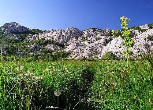 On Stap (860m)
Stap is very beautiful, small field, surrounded with numerous picturesque white cliffs, on altitude of 860m. It is around 500m long and around 200m wide. Stap is open only towards SW (sea) where, behind the edge of the basin, side falls steeply towards 100m lower Sjausevac meadow. On the N is Siroki Kuk (Wide Cliff). On the W are less steep slopes that rise towards the foothills of Debeli Kuk (1269m). East above Stap is group of cliffs in the group of Stapina tower. It rise’s steeply above Stap with smooth cliffs of Babica and culminates with Stapina.
Stap has become inseparable from name of Slavko Tomerlin Tatek who dedicated his life to explore Velebit and especially Stap area. He is one of the most deserving Velebit enthusiasts in last 50 years. After he fell in love with Stap he decided to erect a refuge near the source, in eastern corner of the field, and he did it almost single handedly. Refuge was opened in 1982 and is since called Tatekova Koliba (Tatek's cabin), after his nick name. It can accommodate up to 15 people and is completely equipped with everything one needs to prepare food and stay there. 20 meters from the refuge there is a water source which only becomes dry during summer months. Sometimes after rains it even forms small and short creek which unfortunately quickly disappears in its bed, little bit lower on meadows of Stap. But don't worry, if source is dry there is manual pump few dozen meters behind which was installed by Tatek. He found water in underground cave which it never runs dry. Anyway spare water! Tatek is also an artist, a sculptor, so near the refuge there is a bear face and snake carved in stone. 10mins above the refuge he found an interesting place he called 'The chapel'. In one rocky window he placed a statue of Sv.Antun (Saint Antun) he carved himself.
Tatek completely explored once inaccessible area of wild karst and marked paths to numerous spots of interest like Cucavac rock, The Chapel, Siroka Vrata (wide door), cave in Vodeni Dolac, Kamena Galerija and so on.
Starting point to access Stap is Ljubotic village, at the altitude of 300 meters. Asphalted road reaches it from Kruscica village that is on the coast. In Ljubotic there is a Vrata Velebita camp (Door to Velebit) and interesting graveyard to visit. Since Tatek loves Stap and area so much he decided to be buried in Ljubotic after his death. He carved his own grave in huge stone. Of course, it has a shape of Stapina cliff and its surroundings. On Stapina there are climbers climbing while around there are various animals and mountaineers. Looks amazing.
Except from Ljubotic paths reach or lead away from Stap in 4 directions. Towards north Visocica (1619m) is 3-4h away. Stap is crossed by VPP (Velebit long distance trail) on the way from Sugarska Duliba and Jelova Ruja. From Stap it continues towards Rujno and highest peaks of Velebit. Fourth path approaches from Panos (1258m). When coming from Sugarska Duliba this is better path than going via Jelova Ruja which is longer.
 Autumn on Stap (860m)
Today Stap is quite popular spot for mountaineers, especially from Zadar. It is highly unlikely that no one is there during the weekend but it is rarely overcrowded. From Monday to Thursday it is highly unlikely to meet someone there, except during the summer. If you are climber this area is like a paradise for you, with so many different climbs possible. Have in mind that cliffs around Stap are very smooth so very demanding.
 |  |  |  |
Simonovica Stapina or Stapina (1125m)
44°24'24.27"N, 15°19'38.89"E Giant monolith of Stapina (1125m)
Stapina is trademark of this region of Velebit. It is giant 100m high, self standing monolith cliff which has rounded shape and very smooth sides. Summit is accessible only to climbers. It was named after Radivoj Simonovic, deserving Velebit explorer. On the north is undulating rocky area, covered with nice beech forests, Placed between Stapina and seaboard streak of peaks. In it, closest to Stapina, is rocky Veliko Ploce (1351m). On the south is basin closed by neighboring lower cliffs. At the bottom is meadow surrounded by beech forest. On the west, between Stapina and Stap, is Babica and its very nice white cliffs. In the eastern foothills of Stapina there is a complex of meadows called Cankove Njivice. This is one of most beautiful spots along whole Velebit with fantastic view of Stapina. It is one of those places where one could rest for hours and admire the silence and scenery.
From Stap it takes 30mins to reach the foot of Stapina. This is nice rocky balcony with beautiful views towards sea and islands, Stap, forested peaks in seaboard streak and towards distant Rujno plateau. 10mins in the Rujno direction are Cankove Njivice meadows. See Stap – Rujno (VPP) route for the description.
 Stapina from Cankove Njivice
 |  |  |  |  |
Debeli Kuk (1269m)
44°25'3.79"N, 15°18'34.03"E Debeli Kuk (1269m)
Debeli Kuk is home mountain of Stap. It is quite massive peak with groups of scattered smooth cliffs which offer some demanding courses. Eastern side is grassy while other are under beech forest, except cliffs of course. It belongs to seaboard streak of peaks. Summit of Debeli Kuk is also a cliff which sits on grassy base, something like a crown on the head. Fortunately summit cliff is easy climb for anyone. Debeli Kuk is located 1km NW of Stap, above which it rises some 400m. Area in between (SE of Debeli Kuk) is beautiful park of meadows, forests and cliffs, which is amazingly romantic and beautiful. S, SW and W is area of funnel shaped holes and beech forests which very chaotic and hardly accessible. Especially impressive is Japage area which is unbelievable karts chaos, one of the wildest on entire Velebit, a labyrinth of cliffs and holes covered partly with beech forest. It is true match to northern chaos of Crnopac, on SE Velebit, and Rozanski Kukovi group, on North Velebit, which are much larger areas. On the west is Panos (1258m) which closes this area from that direction. On the north is huge Jelova Ruja basin with enormous beech forests. This area is placed between seaboard and continental streak of peaks. On the east are neighboring nameless peaks in the seaboard streak.
Debeli Kuk is first class panorama point. View from the summit is extensive in all directions and is especially beautiful towards sea & islands. Beautiful ascent from Stap lasts around 1.30h and shouldn’t be missed by anyone who visits Stap. Most of it leads via VPP trail that heads towards Jelova Ruja and Sugarska Duliba.
 |  |  |  |  |
Visovaca (1018m)
Visovaca is rocky peak placed in the first step of seaboard side of Velebit, half way between Panos Vrh (1258m) on the NW and Stap on the E. There is nothing spectacular in the appearance of Visovaca but what makes it a worthy hiking goal is its position! Summit panorama is as amazing as approach itself, which makes Visovaca excellent trip from the Stap. On the way you’ll see some very beautiful meadows and very lonely forests that cover wild carst world of seaboard terrace of Velebit. Most spectacular point in the approach is Japage area, a system of funnel shaped karst depressions, all overgrown by centuries old beech forest! In this forest one can see really giant beech trees in such concentration that is rare on entire Velebit! Between the old giants is dense population of young beeches which on places makes this area a real jungle! Especially beautiful is last third of May when everything around is so saturated with fluorescent green color. By the way are also some nice holes/pits in karst. Feeling of loneliness and isolation of the place is really special. Once out of this amazing area you are stepping on the summit of Visovaca where fantastic sea panorama unfolds before your eyes, as a perfect reward for the effort, while behind is wild and hidden area of South Velebit.And effort is necessary because route is not easy. Visovaca approach branches from Panos Vrh – Sarica Duplje – Stap route on a quite remote and isolated position. And Japage up and down section is still ahead at this point. So, from any direction there are many ups and downs, in Japage some ascents and descents, as path navigates through the system of wild karts, are very steep. This last section is especially challenging if you are coming from distance, for example if you reached Stap from the sea on the same day or if you are coming from Sugarska Duliba direction. So it is best to do Visovaca as a trip from Stap. It takes 2:30h in one direction. Direct approach from Baric Draga on the shore is also possible but marks aren’t reliable at this time. It lasts 3:30-4h.
 |  |  |
Cucavac
Cucavac (read chuchavac) is very interesting large boulder that is standing on steep rocky base like rules of gravity do not apply to it. Being some 20mins from refuge it shouldn't be missed. From its base is beautiful view on Stap and Stapina. Cucavac can be combined with Debeli Kuk and is 10min long detour from that route. |
Kamena Galerija
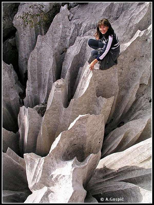 In Kamena Galerija
Kamena Galerija literally means Rock Gallery. No, it is not Cleveland, Ohio rock hall of fame but natures exhibition of amazing rock forms, all gathered in one place. Tatek found this karst labyrinth in the area of Runjava Glava. It contains bridges, doors, windows, deep holes, smooth walls, razor sharp ridges…He marked a complex circular trail that goes from one numbered point to the next one and lasts about an hour. He also named every point of interest like: Prezidana Jama (hole separated in two by a wall), Zlatna Vrata (Golden Door), Terasa Nozeva (Terrace of Knives), Kuloar s Prozorom (Couloir with Window) and so on. On exposed places trail is secured, equipped with steel ropes and even few steel ladders to help descent in one wild hole between two cliffs. It is amazing how he and his assistants brought that heavy material so far into the wild, 4 hours away from Ljubotic village, last accessible by car. It was quite the feat. Kamena Galerija is a MUST for every Stap visitor. Tour of the place lasts 1 hour. It branches from Stap – Rujno route around 1.15h from Stap. Description of the tour is unnecessary, it is better to be surprised.
 |  |  |  |
Vrtlina cave
Vrtlina is one of the largest caves in the area. Its location is 2h from Stap in Rujno and Paklenica direction. Its entrance is at the bottom of large and 50m deep cauldron with very steep, almost perpendicular sides, very well hidden on a plateau in a forest, above the forested valley through which Stap – Rujno route leads. Bottom of cauldron, where is entrance into the cave, cannot be seen from the edge. Cave itself is over 1km long. Exposed descent into cauldron is equipped with steel rope but is only for experienced mountaineers. Don’t go down without flash light and spare batteries. Remember, if something happens down there no one can help you, there is no cell phone signal. Be sure to write in visitors book at Stap refuge that you went there. Recently a student from Zadar went there all alone with two lights. Both died while he was deeper inside. He completely lost orientation and could not get out. There was a huge rescue search in the area but he didn’t tell anyone of his intentions to go in Vrtlina. They found him after 4 days and luckily he was still alive.Views from various points of the area
Stap meadow, the natural gravity point of this area, doesn’t offer distant panoramas because it is closed from all sides by beautiful cliffs. But whole area offers some great view points, which are not necessarily peak summits. | 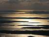 |
Hike Advices
 Spring on Stap
Beside normal approach Stap can also be accessed from 3 different areas of South Velebit. Also there is real net of various shorter trails around Stap that Tatek marked. Number of possibilities is huge. Here are few combinations based on 2-3 day trips.
1) Return same way: closest point to access Stap is Ljubotic village, 2.30h away, where you will leave your car. If Stap and near surroundings are your only goal of the trip you’ll return back to Ljubotic the same way or like under (2), which is more beautiful.
Day 1) reach Stap and explore around
Day 2) return
2) Return the other way: access Stap from Ljubotic like under (1) and climb Debeli Kuk and visit Cucavac in the afternoon. On the 2nd day from Stap you head in Rujno & Paklenica direction. By the way is Stapina and soon after junction towards Kamena Galerija. At next junction (1.45h from Stap without Kamena Galerija detour) follow Vrtlina cave direction. In some 15mins path reaches grassy plateau. Don’t follow marks when they turn left towards Vrtlina but continue straight across grassy plateau. From its edge you can see Bili Sinokos pastures, some 150m bellow. You just have to descent through unmarked forest. There is even a path going down but you will not easily find it. Once down, on the field, continue straight towards pass, in same (SW) direction, while sticking to right edge of the field. Where short ascent towards pass begins you’ll finds marks again which will take you to Ljubotic (1.45h) via Ranjevac. Unmarked section is only around 30-45mins long and orientation is not difficult.
This way you can visit Stapina, Kamena Galerija & Vrtlina cave during return, which are all just by the way.
Day 1) reach Stap and explore around
Day 2) return
3) Extended trip: two possibilities stand out here. One will take you back to your car in Ljubotic while in other option you descent in Paklenica National Park. Hikes are for those which are in at least very good shape. Both hikes are among few of the best on South Velebit with amazing vistas.
Option 1) on the 1st day reach Stap and explore around. Visit Stapina & Kamena Galerija in the afternoon. 2nd day is gigantic route with 9h of walking. First on the menu is Visocica peak, one of the most beautiful on South Velebit (3h from Stap). From Visocica you continue towards Struge where you’ll sleep in Struge refuge (6h from Visocica). On this section you’ll experience some amazing wilderness, far from civilization, passing through beautiful beech forests mixed with spruce and fir, walk over huge, high lying fields of Oglavinovac and Javornik. 3rd day is another long distance day. First you reach Buljma pass (Paklenica direction) and descent on Rujno, biggest field on Velebit, which is 7km long. From Rujno you head towards Stap. At half way between Rujno and Stap you turn left towards Vrtlina cave and descent to Ljubotic like in (2).
Option 2) on the 1st day reach Stap and climb Debeli Kuk to enjoy beautiful panorama, also visit Cucavac. On the 2nd day head towards Rujno. First you’ll pass by Stapina. 30mins later is junction towards Kamena Galerija. Don’t miss it, it is only an hour long detour. From Rujno head towards Paklenica and Struge, where you’ll sleep over (8hours from Stap). On the 3rd day climb Vaganski Vrh (1757m) (2.30h), highest peak of Velebit and descent to Paklenica (3.30h) or, if you are in great shape, continue all the way to Sveto Brdo (1751m) (4h) and then descent to Paklenica (4h) or Vlaski Grad refuge (1.30h). On the 4th day go to Starigrad Paklenica where you’ll have to wait a bus towards Rijeka which will take you to Kruscica or hitch-hike. Your car is now hour away, 300m above in Ljubotic. Ask locals if anyone is going to Ljubotic to take you along. If you descent to Paklenica directly from Vaganski Vrh you still have time to get to your car during 3rd day.
4) Passing by: this variation is for those that are doing VPP (Velebit long distance trail). When coming from Sugarska Duliba, just before descending to Stap there is a junction towards Debeli Kuk. Don’t miss it if you have any more strength and will left. Stap is usual sleep point on VPP so end of the day is near. When you continue tomorrow towards Rujno and Struge you’ll pass by Stapina. Little bit later don’t miss to visit Kamena Galerija.
 |  |  |  |
Getting There
Starting point to access Stap is Ljubotic village on the slopes of Velebit, 300m above the sea, which is reachable by car from Kruscica on the coast. Kruscica is 13km in Rijeka direction from Starigrad Paklenica, which is a center of the area and starting point to visit Paklenica NP. Bellow you’ll find info how to get to Kruscica.by Plane
Closest airport is in Zadar, 58km away. There are no international flights to Zadar (except charter flights during summer season) so you have to go over Zagreb international airport. There are everyday flights from Zagreb to Zadar. More info about flights find on official site of Croatia Airlines. From Zadar you must take a bus to Kruscica (Rijeka direction).
by Bus
There are numerous bus lines from Zagreb to Zadar each day, almost every half hour. The only problem is in the fact that there is no direct bus to Kruscica from Zagreb. You have to board the bus to Zadar and then towards Rijeka, which are also frequent during the day. Detailed bus timetables from Zagreb find on Zagreb bus station site.
by Car
This is always best possible option which gives you freedom to do and go wherever you want. There are two main directions to come to this area, from Rijeka or Zagreb.
From Rijeka, along the coast
This route is suitable if you are coming from western Europe, via Trieste (Italy).
Trieste – Rijeka: 70km
Rijeka – Kruscica: 167km
From Zagreb
This road is suitable if you are coming from eastern or central Europe via Ljubljana (Slovenia), Maribor (Slovenia) or Budapest (Hungary).
Ljubljana – Zagreb: 138km, Maribor – Zagreb: 113km, Budapest – Zagreb: 347km
Zagreb - Kruscica (via Plitvice and Starigrad Paklenica): 262 km
Look for current road conditions in Croatia on the page of Croatian Automobile Club (HAK)
 |  |
When To Climb
 Between Stap and Rujno
Find more about climate on the main page of Velebit.
Certainly climate on Stap is less harsh than among highest peaks and higher parts of Velebit. As any mountain it can be visited year round. In winter crampons are not necessary if you don’t go beyond refuge. Walking poles are good to have. Snow is frequent in winter on Stap but it doesn’t cover the ground all the time. It always melts and falls again. While you won’t frequently find snow on the very Stap field as soon as you enter the forest above it you can count on snow, which can be hard packed.
In summer you don’t need anything except lot of water. Nights on Stap are fresh even in summer so always have some warmer clothes with you.
Most beautiful time to visit Stap is May or October. In May everything is fresh green with lot of flowers while in October fall colors are beautiful.
 |
Mountain Conditions
Conditions on Velebit are very well known thanks to Zavizan meteo station, which is observing weather since 1953. On WeatherOnline & DHMZ (Croatian Meteorological and Hydrological Association) sites you can find current data for Zavizan and even forecast for Zavizan on WeatherOnline. Also close forecast towns are Gospic & Zadar.Here are the links where you can find out about the current weather on Velebit (Zavizan) and forecast for Croatia:
WeatherOnline:
WeatherOnline home page
Croatia at WeatherOnline,
Zavizan at WeatherOnline
Croatian Meteorological and Hydrological Association (DHMZ):
DHMZ home page
DHMZ Forecast page
DHMZ 7 Day Forecast for Croatian cities and places World wide, including Zadar and Gospic
Current Weather Conditions in Croatia including Zavizan, Gospic and Zadar (from 4-14h and 19-21h, during summer +1hour)
Snow Depth's in Croatia
Objects
Tatekova Koliba (860m) refuge is one of the most romantic on whole Velebit. That includes both place and the very refuge. It was build by Slavko Tomerlin – Tatek, deserving Velebit enthusiast. Refuge was opened in 1982 and is since called Tatekova Koliba (Tatek's cabin), after his nick name. It can accommodate up to 15 people and is completely equipped with everything one needs to prepare food and stay there. Inside it is completely covered with wood which gives very warm atmosphere. Water is 10m from refuge. |  |
Camping & Accommodation
Stap is very suitable for camping because of water source and soft meadows.In Ljubotic (Stap trailhead) there is a Vrata Velebita camp (Door to Velebit).
More info on accommodations & camping you can find on Starigrad Paklenica Riviera site or Adriatica.net, online searching & booking site for Croatian coast and wider.
Red Tape
Whole Velebit is Park of Nature. There are no entrance fees, except in national parks. Rules that apply here are same as anywhere which means preserve nature, take your garbage back to the valley with you, don't pick flowers.Other Velebit pages on SummitPost
~ Velebit massif, main page~ Zavizan area, North Velebit (Mali Rajinac (1699m) highest peak on the page)
~ Rozanski Kukovi group, North Velebit (Gromovaca (1676m) & Vratarski Kuk (1676m) highest peaks on the page)
~ Alancic / Rozanski Vrh / Seravski Vrh, North Velebit (Goli Vrh (1670m) highest peak on the page)
~ Veliki Kozjak (1629m), North Velebit
~ Satorina (1624m), Mid Velebit (including whole area between it and Alan pass)
~ Visocica (1619m), South Velebit
~ Bojin Kuk (1110m), South Velebit
~ Viserujna (1632m) & Rujno, South Velebit
~ Paklenica area, South Velebit
~ Vaganski vrh (1757m), South Velebit (highest peak of Velebit)
~ Liburnija (1710m), South Velebit
~ Sveto Brdo (1751m), South Velebit
~ Tulove Grede (1120m), SE Velebit
~ Crnopac (1404m), SE Velebit
Note: Text on this and pages above is copyrighted and cannot be used in any kind of publications.