
|
|
Mountain/Rock |
|---|---|
|
|
44.42380°N / 15.36850°E |
|
|
5311 ft / 1619 m |
|
|
Google Earth
Since Google has blessed us with its magical Google Earth software you can visit any corner of the world from the chair parked in front of your computer. Thankfully Velebit is amazingly clear so you can discover its corners and see for yourself how it looks from the above and where are the places this page is dedicated to.Each geographical point of interest described on this page has coordinates on the top of its section. You can use these coordinates with Google Earth’s fly to search engine. Just copy the coordinates (like it is written, with coma) and paste them into fly to tab and press enter. And, of course, enjoy the flight!
Intro
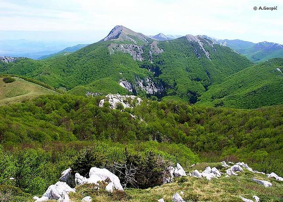
Visocica (1619m) from Vilinski Kuk (1401m)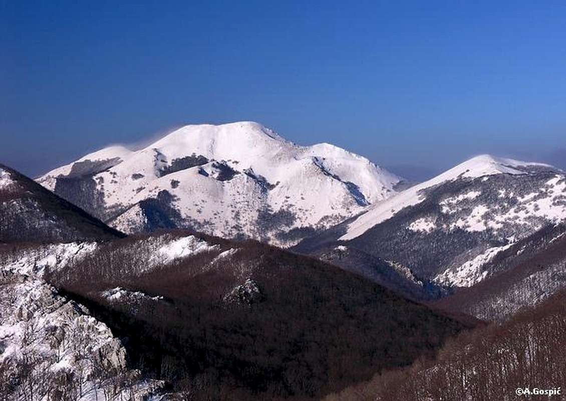 From Zavizan group on North Velebit to Satorina (1624m) on Mid Velebit, peaks of Velebit constantly exceed 1600m. But then they begin to loose height. Around Ostarije pass, which is border between Mid and South Velebit, peaks are around 1300m high. South Velebit begins to gradually gain altitude again as many peaks in Sadikovac - Samari group exceed 1400m. Visocica is first peak of South Velebit that exceeds 1600 meters. It is not positioned very high on the list of highest peaks of South Velebit and even more so of Velebit in general. But thanks to its interesting position and nice shape Visocica is one of better known and recognized peaks of Velebit. View from the summit is quite different and unique as it reveals some hidden places of inner South Velebit. Many say that it is among the best on Velebit. From Zavizan group on North Velebit to Satorina (1624m) on Mid Velebit, peaks of Velebit constantly exceed 1600m. But then they begin to loose height. Around Ostarije pass, which is border between Mid and South Velebit, peaks are around 1300m high. South Velebit begins to gradually gain altitude again as many peaks in Sadikovac - Samari group exceed 1400m. Visocica is first peak of South Velebit that exceeds 1600 meters. It is not positioned very high on the list of highest peaks of South Velebit and even more so of Velebit in general. But thanks to its interesting position and nice shape Visocica is one of better known and recognized peaks of Velebit. View from the summit is quite different and unique as it reveals some hidden places of inner South Velebit. Many say that it is among the best on Velebit. |
 |  |  |  |  |
Visocica (1619m)
44°25'43.25"N, 15°22'11.52"EGolden autumn slopes of Visocica (1619m)
 Visocica (should be read Visochica) is a grassy giant that dominates in this part of Velebit. It is shaped like huge pyramid with flat summit, depending from which position it is viewed. Visocica is placed in continental streak of South Velebit peaks and it towers above Lika region towards which (NE) falls uninterrupted some 1100m. Slope is very steep, especially above forest line which is at 1400m, made of layers of limestone cliffs and scree, with some dwarf pine. Somewhere on this slope at the altitude of 1500m, hidden among colonies of dwarf pine, is Ivino Vrelo source. Forested part of the slope is bit less steep and is overgrown by beech mostly which is mixed with some spruce and fir. From all other sides Visocica is grassy but also steep. SW slope is around 300m high and rises above huge depression of inner Velebit which is placed between seaboard and continental streaks of peaks. This area is also covered by beech forests with some spruce and fir and is without any marked paths, completely unvisited by mountaineers. This is true wilderness where wild animals like bears and wolfs live. SE of Visocica is grassy Mala Visocica (1500m) (Small Visocica) or Seline. Between both peaks is deep pass. On the way towards Struge marks descent down on this pass and climb Mala Visocica on the other side. On the NW is Jandrina Poljana, a meadow surrounded with beech, fir & spruce forest. It lies in the valley, at its end close to continental slope of Velebit, which divides Visocica group from Troseljev Vrh (1445m) group. Through this valley goes Stap – Visocica route. In front of western part of Visocica is massive Siljak (1491m) peak. On the saddle between it and Visocica are ruins of former Gojtanov Dom hut (1400m) which was set a blaze by Croatian Army, during independence war, to prevent Serbs from using it in the case they seize this part of Velebit. Gojtanov Dom was beautifully positioned at the edge of forest line on the slopes of Visocica, hopefully it will be rebuilt. Just by the ruins of the hut water cistern with good water. Visocica (should be read Visochica) is a grassy giant that dominates in this part of Velebit. It is shaped like huge pyramid with flat summit, depending from which position it is viewed. Visocica is placed in continental streak of South Velebit peaks and it towers above Lika region towards which (NE) falls uninterrupted some 1100m. Slope is very steep, especially above forest line which is at 1400m, made of layers of limestone cliffs and scree, with some dwarf pine. Somewhere on this slope at the altitude of 1500m, hidden among colonies of dwarf pine, is Ivino Vrelo source. Forested part of the slope is bit less steep and is overgrown by beech mostly which is mixed with some spruce and fir. From all other sides Visocica is grassy but also steep. SW slope is around 300m high and rises above huge depression of inner Velebit which is placed between seaboard and continental streaks of peaks. This area is also covered by beech forests with some spruce and fir and is without any marked paths, completely unvisited by mountaineers. This is true wilderness where wild animals like bears and wolfs live. SE of Visocica is grassy Mala Visocica (1500m) (Small Visocica) or Seline. Between both peaks is deep pass. On the way towards Struge marks descent down on this pass and climb Mala Visocica on the other side. On the NW is Jandrina Poljana, a meadow surrounded with beech, fir & spruce forest. It lies in the valley, at its end close to continental slope of Velebit, which divides Visocica group from Troseljev Vrh (1445m) group. Through this valley goes Stap – Visocica route. In front of western part of Visocica is massive Siljak (1491m) peak. On the saddle between it and Visocica are ruins of former Gojtanov Dom hut (1400m) which was set a blaze by Croatian Army, during independence war, to prevent Serbs from using it in the case they seize this part of Velebit. Gojtanov Dom was beautifully positioned at the edge of forest line on the slopes of Visocica, hopefully it will be rebuilt. Just by the ruins of the hut water cistern with good water. |
 |  |  |  |  |
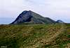
Visocica from Distance
Visocica (1619m) across the Jandrina Poljana valley from Troseljev Vrh (1445m)
 |  |
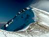
Summit View
Many consider Visocica as one of best view points on whole Velebit. View is certainly fantastic but I would say that it depends what you like to view. If you prefer huge Lika plateau and continental side of Velebit, depression of inner Velebit and its huge beech forests Visocica is certainly among the best. But most Velebit visitors prefers to view sea and islands and in that aspect view from Visocica is not close to that from Viserujna (1632m), Liburnija (1710m) or Sveto Brdo (1751m) because it is partially restricted by seaboard streak of peaks. Anyway view is very wide in all directions, reaching even few hundred kilometers distant Italy across Adriatic sea.W: behind the numerous peaks of South Velebit (Sadikovac – Stolac group) is Adriatic Sea and islands.


---------------------------------------------------------------------------------------------
NW: Velebit stretches in this direction so many closer and farther peaks of South, Mid and North Velebit are visible.


---------------------------------------------------------------------------------------------
N: Gospic town is quite close to Velebit. It noticeable in the mid part of the field as larger group of tiny houses. Behind huge flat Lika region, in the distance, is Kapela mountain. Lika region is split in two parts by Licko Sredogorje massif which is around 1200m high.
---------------------------------------------------------------------------------------------
NE: Lika dominates this side of panorama also but closing it now on the opposite side is Licka Pljesivica mountain with Gola Pljesivica (1648m) and further towards right Ozeblin (1657m), highest peak of Licka Pljesivica.
---------------------------------------------------------------------------------------------
E: behind Lika and Licko Sredogorje massif is still Licka Pljesivica mountain with Kremen (1591m). Just right of Kremen is Osjecenica (1798m) mountain in Bosnia. Further right is Klekovaca (1961m) mountain, also in Bosnia.
---------------------------------------------------------------------------------------------
SE: again the direction towards which Velebit stretches. Just below is grassy Mala Visocica (1500m). Behind are all the peaks of continental streak and of inner Velebit. Further behind is Babin Vrh (1738m) & Zoranicev Vrh (1712m) which are placed on NW end of Vaganski Vrh – Sveto Brdo group. Behind the pass between Jelovac (1601m) and Kozjak (1572m) peaks of inner Velebit is Viserujna (1632m).


---------------------------------------------------------------------------------------------
S: below Visocica is large forested area of inner Velebit with seaboard streak of peaks behind it. Further back is Ravni Kotari county with Zadar city on its edge (hard to spot). Behind Zadar is its archipelagos.


---------------------------------------------------------------------------------------------
SW: same as towards S but more islands replace Ravni Kotari, just behind seaboard streak of peaks.

Visocica – Badanj group
Two main peaks of the region are Visocica on NW and Badanj on SE. Naturally they create Visocica - Badanj group which stretches from Jelova Ruja - Sarica Duplje depression, where it borders with Sadikovac – Stolac group, till Struge plateau where it borders with Vaganski Vrh - Sveto Brdo group. Group consists of Seaboard and Continental streaks of peaks. Between them is inner depression of South Velebit which consists of huge complexes of beech forest with some fir & spruce and large high lying grassy fields, some of which are few kilometers long.Important in continental streak are:
~ Troseljev Vrh (1445m)
~ Visocica (1619m)
~ Pociteljski Vrh (1551m)
~ Golovrhe (1591m)
~ Visibaba (1610m)
~ Badanjski Vrh (1627m)
~ Badanj (1639m)
Between these two streaks there are few isolated peaks, which are rising considerably above the inner Velebit depression:
~ Siljak (1491m), in front of Visocica
~ Jelovac or Celavac (1601m)
~ Kozjak (1572m)
Peaks of seaboard streak rise above the seaboard terrace of South Velebit, which is described on Stap and Viserujna (1632m) & Rujno pages. Important are:
~ Debeli Kuk (1269m), above Stap
~ Veliki Ploceviti (1352m)
~ Golic (1424m), above Carabusa
~ Bobicki Kuk (1439m), above Duboki Dol
~ Vilinski Kuk (1401m), above Malo Rujno
~ Viserujna (1632m), above Veliko Rujno
Previously mentioned fields and plateaus of inner Velebit, which lie between two streaks of peaks, have been for centuries used as summer pastures of people living bellow the mountain. In modern days that way of living died. Today these fields are romantic and calm places where you desire to rest whole day. Visocica – Struge route crosses all of them. Important are:
~ Rudina meadows, between Visocica and Pociteljski Vrh
~ Janjcarica meadows, below Pociteljski Vrh
~ Oglavinovac field, 2km in diameter
~ Javornik field, 3km long, almost 1 km wide
~ Struge plateau, divided on upper and lower Struge, 2.5km long, more than 1km wide
 |  |  |  |  |
About Routes
Visocica can be accessed from 4 directions: Stap (coast), Rizvanusa (Lika) or via VPP (Velebit Long Distance Trail) which crosses it. To be correct VPP used to cross Visocica till 90’s war on the way from Ostarije pass via Sugarska Duliba area on the way towards Paklenica area. Because of danger from laid mines on this area VPP was redirected to seaboard terrace of South Velebit (Stap & Rujno areas). Former route of VPP was inspected by some mountaineers which were in war on Velebit. Their opinion is that there are no mines on the route and that it is passable but without too much wandering around. HPS (Croatian Mountaineering Organization) still considers the route dangerous and doesn’t recommend it, so new VPP route remained. I used the route many times since and know many others who did. There weren’t any incidents. Anyway using Visocica – Struge route is your own responsibility.Most beautiful way to approach Visocica is from coast via Stap area and continue towards Paklenica National Park and highest peaks group via old VPP route. 6h long section from Visocica to Struge is today very rarely visited. It is amazing area, far from civilization. On the way you pass grassy peaks, idyllic beech forests, soft meadows and huge grassy fields which lie on the bottom of inner Velebit depression. This is one of those spot on Velebit where you have a feeling like there is no one else in the world, it is just you and untouched nature.
Easiest way to climb Visocica is to use forest macadam road that ascends from Rizvanusa village in Lika, 10km from Gospic town in Ostarije (927m) pass and Karlobag town (coast) direction. Road ends just 1.30h below Visocica but I highly not recommend this to anyone who wants to explore and get to know Velebit beauties. On foot this is long and boring road ascent, non stop through the forest, which lasts 4h (till the end of road). Use this road approach only if you have already explored some area of Velebit and you want to pick up Visocica also before going home.
 |  |  |  |  |
Hike Advices
Visocica is great peak to combine with Stap, Rujno and Paklenica areas (Vaganski Vrh, Liburnija & Sveto Brdo pages). Number of possibilities is huge. Of course, easiest way to climb Visocica is from Lika region using macadam road which brings you 1.30h from the summit. I will exclude it from any combination because it is boring and very tough to combine with coastal ascents because getting back to your car would be nightmare.1) Simplest 2 day combination is to climb via Stap and return same way. On the 1st day reach Stap from Ljubotic (2.30h). After leaving rucksack at refuge visit Kamena Galerija and return to refuge (3.30h). On the 2nd day go to Visocica (3.30-4h) and return to Stap (3.15h) and further to Ljubotic (2.15h).
2) Extended 3 day trip: 1st day is same as in the 1) combination. On the 2nd day climb Visocica (3.30-4h) and continue towards Struge refuge (6h). 3rd day gives you number of options: a) return to Ljubotic (where is your car) via Buljma, Rujno (from Buljma pass is same as on Viserujna Circle route & Vrtlina (check Stap page). b) you can descent to Paklenica directly via Buljma pass (2.30h) and Starigrad Paklenica on the coast (1.30h). From Starigrad return to Kruscica by bus or hitch-hike. Walk from Kruscica to Ljubotic (1h) or ask someone in Kruscica to drive you there. c) from Struge refuge climb Vaganski Vrh (1757m), highest peak of Velebit (Paklenica hut – Struge – Vaganski Vrh route (2.30h). From Vaganski Vrh you can descent to Paklenica via Lipa Staza (3.30h) or via Liburnija (1710m) (1h from Vaganski vrh) and further down to Paklenica via Paklenica hut – Liburnija route (4h). From Paklenica hut to Starigrad and Ljubotic (where is your car) same as under b).
Note: if you are in the hurry and have only 2 days available you could still do extended 3 day trip. But this is only for those in very good shape because first day is real monster 12h long marathon! You have to put 1st & 2nd day in one without going Kamena Galerija near Stap. Once I did this combination and it is definitely among few toughest ever on Velebit for me. I started at 8am from Ljubotic and reached Struge refuge at 10.30pm and it wasn’t normal walking but almost running at the end of the day. Those 2.30h above 12h were rests. Make sure you have good flash light to search marks through dark forest during last hour of the route. On the 3rd day you can pick either of 3 combinations.
3) Extended 4 day trip: 1st & 2nd day are same as under 2). On the 3rd day from Struge refuge climb Vaganski Vrh (1757m), highest peak of Velebit (Paklenica hut – Struge – Vaganski Vrh route (2.30h). Continue towards Sveto Brdo (1751m), second highest peak of Velebit and best view point on whole mountain (4h). Descent to Vlaski Grad refuge to sleep over (1.30h). On the 4th day descent to coast via Mala Paklenica route (7h) or Velika Paklenica route (5.50h). From either Seline or Starigrad Paklenica return to car same way as under 2b).
Note: if you are in a group which has at least to cars and you are planning to descent to coast via Paklenica leave on car here before heading towards Ljubotic and Stap. If there are many of you to go there with one car it would be best for drivers to leave you in Ljubotic and go to Paklenica to leave one car. You will loose 1.30h maximum but it will spare you lot of trouble after you descent tired from the mountain. First day in any combination is not to long so you have enough time to do it.
 |
Getting There
There are 2 different starting points to climb Visocica and they are on opposite sides of the mountain, one from the coast, the other from continental side.~Coastal trailhead~
Starting point to access Visocica from the coast is Ljubotic village on the slopes of Velebit, 300m above the sea, reachable by car from Kruscica on the coast. Kruscica is 13km in Rijeka direction from Starigrad Paklenica, which is a center of the area and starting point to visit Paklenica NP. Bellow you’ll find info how to get to Kruscica.
by Plane
Closest airport is in Zadar, 58 km away. There are no international flights to Zadar (except charter flights during summer season) so you have to go over Zagreb international airport. There are everyday flights from Zagreb to Zadar except on sunday. More info about flights find on official site of Croatia Airlines. From Zadar you must take a bus to Kruscica (Rijeka direction).
by Bus
There are numerous bus lines from Zagreb to Zadar each day, almost every half hour. The only problem is in the fact that there is no direct bus to Kruscica from Zagreb. You have to board the bus to Zadar and then towards Rijeka, which are also frequent during the day. Detailed bus timetables from Zagreb find on Zagreb bus station site.
by Train
Train is worst possible option to get to Kruscica from Zagreb. It travells longer than bus and you have to change the train in Knin towards Zadar and then take a bus towards Rijeka. Train timetables are on Croatian railways site.
by Car
This is always best possible option which gives you freedom to do and go wherever you want. There are three main directions to come to this area, from Rijeka, Zagreb or Zadar.
From Rijeka, along the coast.
This route is suitable if you are coming from western Europe, via Trieste (Italy).
Trieste - Rijeka 70 km
Rijeka - Kruscica 167 km
From Zagreb.
This road is suitable if you are coming from eastern or central Europe via Ljubljana (Slovenia), Maribor (Slovenia) or Budapest (Hungary).
Ljubljana - Zagreb 138 km, Maribor - Zagreb 113 km, Budapest - Zagreb 347 km
Zagreb - Kruscica (via Plitvice and Starigrad Paklenica) 262 km
Zadar – Starigrad Paklenica – Kruscica: 55km
Look for current road conditions in Croatia on the page of Croatian Automobile Club (HAK)
~Continental trailhead~
Starting point to access Visocica from the continent is Rizvanusa village at the foothill of Velebit, 10km from Gospic town.
by Plane
Closest airport is in Zagreb, km away. More info about flights find on official site of Croatia Airlines. From Zagreb you will continue towards Gospic by bus or train.
by Bus
Detailed bus timetables from Zagreb find on Zagreb bus station site. From Gospic take a local bus which goes over Velebit towards Karlobag town on the coast. You will get off in Rizvanusa village.
by Train
Train timetables are on Croatian railways site. From Zagreb towards Gospic trains go several times per day. From Gospic take a local bus which goes over Velebit towards Karlobag town on the coast. You will get off in Rizvanusa village.
by Car
This is always best possible option which gives you freedom to do and go wherever you want. There are three main directions to come to this area, from Rijeka, Zagreb or Zadar.
From Rijeka, along the coast.
This route is suitable if you are coming from western Europe, via Trieste (Italy).
Trieste - Rijeka 70 km
Rijeka – Senj – Karlobag – Gospic: 179km km (Rizvanusa 169km)
From Zagreb.
This road is suitable if you are coming from eastern or central Europe via Ljubljana (Slovenia), Maribor (Slovenia) or Budapest (Hungary).
Ljubljana - Zagreb 138km, Maribor - Zagreb 113km, Budapest - Zagreb 347km
Zagreb – Karlovac - Plitvice – Korenica – Gospic – Rizvanusa: 217km
Zadar - Gospic: 85km
 |  |  |
When To Climb
Find out more about climate on Velebit main page.Winter lasts from November to end of April. Crampons are always necessary in this period. Ice ax can be replaced by walking poles but it is better to have it because in winter you can’t be sure you won’t need it. Visocica has harsh climate of high Velebit so good forecast is essential. Most dangerous factor is Bura wind which reaches hurricane force on Velebit, especially on passes and summit ridges. Good thing is that Visocica routes go mostly through forest which protects you from weather extremes. Only final 40mins are exposed grassy slopes.
Summer on Visocica is compressed in July and August. Forest provides excellent shade during summer.
Autumn months are September and October. September is already fresh on Visocica and in last third of month autumn colors begin to appear. It is not strange if snow falls even at the end of August but it won’t remain long on the ground till the end of October, which is one of most beautiful months during the year to visit because routes leading to Visocica are painted in fantastic colors.
Spring months on Visocica are May and June. Then everything is fresh, fluorescent green with lot of flowers. By the end of June it is already hot. Depending on the year May can also be winter month on Visocica. Snow in May is regular but it won’t last too long. On good snow year Visocica can be under snow till last third of May while northern slopes much longer.
Mountain Conditions
Conditions on Velebit are very well known thanks to Zavizan meteo station, which is observing weather since 1953. On WeatherOnline & DHMZ (Croatian Meteorological and Hydrological Association) sites you can find current data for Zavizan and recently even forecast for Zavizan on WeatherOnline. Also you can check forecasts for Gospic & Zadar cities which are close to Velebit.Here are the links where you can find out about the current weather on Velebit (Zavizan) and forecast for Croatia:
WeatherOnline:
WeatherOnline home page
Croatia at WeatherOnline,
Zavizan at WeatherOnline
Croatian Meteorological and Hydrological Association (DHMZ):
DHMZ home page
DHMZ Forecast page
DHMZ 7 Day Forecast for Croatian cities and places World wide, including Zadar and Gospic
Current Weather Conditions in Croatia including Zavizan, Gospic and Zadar (from 5-15h and 19-21h, during summer +1hour)
Snow Depth's in Croatia
Objects
Unfortunately beautifully positioned Gojtanov Dom (1400m) hut on Visocica is in ruins after 90’s independence war. Hopefully it will be rebuild by mountaineers from Gospic who managed it before the war. Just by the hut is refuge which is also in terrible condition and is merely a shelter in case of bad weather.Tatekova Koliba (860m) refuge on Stap (if coming from coast via Stap)
is one of the most romantic on whole Velebit. That includes both place and the very refuge. It was build by Slavko Tomerlin – Tatek, deserving Velebit enthusiast. Refuge was opened in 1982 and is since called Tatekova Koliba (Tatek's cabin), after his nick name. It can accommodate up to 15 people and is completely equipped with everything one needs to prepare food and stay there. Inside it is completely covered with wood which gives very warm atmosphere. Water is 10m from refuge.
Other 'closer' refuge is Struge refuge on Struge plateau (6h from Visocica). But one will use it only if doing one of Visocica extended trips. Info about refuge is on Vaganski Vrh or Liburnija pages.
Camping & Accommodation
Stap, mid point from coast to Visocica, is very suitable for camping because of water source and soft meadows.In Ljubotic (Stap trailhead) there is a 'Vrata Velebita' camp (Door to Velebit).
More info on accommodations below the mountain you can find on Starigrad Paklenica riviera site.
If you are climbing Visocica from continental side you can use Velebno hotel in Baske Ostarije village (920m). Village is placed in the depression which divides Mid from South Velebit, near Stara Vrata pass (927m). Hotel is 12km uphill from Rizvanusa village, trailhead of Rizvanusa route.
You can also find accommodation in Gospic town.
Red Tape
No limits.Other Velebit pages on SummitPost
~ Velebit mountain, main page~ Zavizan area, North Velebit (Mali Rajinac (1699m) highest peak on the page)
~ Rozanski Kukovi group, North Velebit (Gromovaca (1676m) & Vratarski Kuk (1676m) highest peaks on the page)
~ Alancic / Rozanski Vrh / Seravski Vrh, North Velebit (Goli Vrh (1670m) highest peak on the page)
~ Veliki Kozjak (1629m), North Velebit
~ Satorina (1624m), Mid Velebit (including whole area between it and Alan pass)
~ Stap area, South Velebit, (Debeli Kuk (1269m) highest peak on the page)
~ Bojin Kuk (1110m), South Velebit
~ Viserujna (1632m) & Rujno, South Velebit
~ Paklenica area, South Velebit
~ Vaganski vrh (1757m), South Velebit (highest peak of Velebit)
~ Liburnija (1710m), South Velebit
~ Sveto Brdo (1751m), South Velebit
~ Tulove Grede (1120m), SE Velebit
~ Crnopac (1404m), SE Velebit
Note: Text on this and pages above is copyrighted and cannot be used in any kind of publications.