
|
|
Mountain/Rock |
|---|---|
|
|
44.37180°N / 15.44130°E |
|
|
Hiking, Mountaineering |
|
|
Spring, Summer, Fall, Winter |
|
|
5354 ft / 1632 m |
|
|
Google Earth
Since Google has blessed us with its magical Google Earth software you can visit any corner of the world from the chair parked in front of your computer. Thankfully Velebit is amazingly clear so you can discover its corners and see for yourself how it looks from the above and where are the places this page is dedicated to.Each geographical point of interest described on this page has coordinates on the top of its section. You can use these coordinates with Google Earth’s fly to search engine. Just copy the coordinates (like it is written, with coma) and paste them into fly to tab and press enter. And, of course, enjoy the flight!
Intro
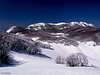
 Viserujna (1632m) & Bojin Kuk (1110m) from Ravni Kotari
Page you’ve opened is dedicated to beautiful area which is placed between Stap area on the NW and Paklenica area on the SE. This part of South Velebit is led by Viserujna (1632m), a mountain within mountain, which dominates above Veliko Rujno plateau. Page is not only dedicated to this beautiful mountain but also to surrounding area, that is placed on the seaboard terrace, which stretches along whole Velebit. On some places it is wider, on the other narrower. This section of seaboard terrace, between Stap and Rujno, is probably the most beautiful along whole mountain. It lies at the altitude of around 900m and is strewn with rugged rocky basins whose bottoms are soft grassy fields and meadows. Terrace is closed from the sea by the seaboard streak of peaks, or so called 1st step. Dominating above the terrace are peaks that belong to high part of the mountain. Paths of this area are natural bridge when combining routes between Stap area and Paklenica area, which contains highest peaks of Velebit, led by Vaganski vrh (1757m) & Sveto Brdo (1751m). This area is among top 3 I would recommend if you are visiting Velebit mountain for the first time!
 |  |  |  |  |  |
Viserujna (1632m)
 Debelo Brdo section of Viserujna (1632m) from Veliko Rujno
Korovilje: 44°22'33.03"N, 15°25'36.70"E
2nd highest point: 44°22'35.26"N, 15°26'27.26"E
Main summit: 44°22'30.59"N, 15°26'48.16"E
Debelo Brdo: 44°22'15.76"N, 15°26'55.96"E
Tadina Glavica: 44°22'3.88"N, 15°27'36.25"E
Viserujna is huge mountain, one of largest on Velebit. It is placed inside Paklenica National Park. With its 4km wide shoulders it protects Veliko Rujno field, which is 700m bellow. From its very long summit ridge amazing views expand few hundred kilometers, all the way across Adriatic sea to Italy, when atmosphere is clear enough. But it is especially beautiful towards closer sea, islands and this very sweet part of Velebit. Other important thing is that Viserujna is path and marks free. If you never moved away from marked paths this is good place to start because orientation is easy while feeling of being away from usual routes is something special to discover. If you meet anyone here perhaps that was good day to play lottery. All this makes Viserujna a worthy mountain goal.
What is around Viserujna? On the NW is Ribnicka Vrata (1250m) pass while on the opposite, SE end of the massif is Buljma (1400m) pass which separates it from Vaganski Vrh - Sveto Brdo group that contains highest peaks of Velebit. As said above, on the SW Viserujna rises above Veliko Rujno field (850-900m) and that is how it got its name. Viserujna means above Rujno. Extreme SE end of Viserujna is no longer above Rujno but falls deep into the Brezimenjaca valley, which is part of upper Paklenica valley. On the NE & E are Javornik (1250-1300m) and Struge (1400m) grassy fields or plateaus, which lie in the high placed valley or depression that separates seaboard streak of peaks, which includes Viserujna, from continental streak of peaks.
Lower 2/3 of Viserujna above Rujno are forested with black pine and beech forests while upper third are very steep grassy slopes with horizontal layers of cliffs. Some are up to 100m high. Northern side of Viserujna, above Javornik, is forested with beech and some spruce and fir. Close to the ridge and summits, before it retreats in front of grassy slopes, forest is stunted by extreme winds. On the grass and rock, especially on the northern side, there is quite a lot of dwarf pine.
Along the ridge there are 5 distinctive summits. On the NW, rising steeply above Ribnicka Vrata pass, is Korovilje (1500m). In the mid part there are 3 summits. NW summit is large and rocky with some cliffs. It is around 1615m high. In the middle is main summit or Viserujna (1632m). Next is Debelo Brdo (1605m) which is separated from main summit with very narrow pass that is surrounded by cliffs and looks like doors. Finally on the SE end, just above Buljma pass, is Tadina Glavica (1495m) which falls with cliffs towards Paklenica valley.
 |  |  |  |  |  |  |
Summit View
As briefly said in previous section view from the summit is beautiful, no it’s fantastic. Walking along 4km long summit ridge of Viserujna is like being on amazing balcony above the sea and largest terrace of Velebit, Rujno field. If weather is clear enough view will reach Italy, all the way across Adriatic sea. But Viserujna is not just about wide views towards sea and islands. From its peaks various vistas of this beautiful part of Velebit change. Some things which are visible from Korovilje are not visible from Debelo Brdo and so on. To not complicate to much here is the description of view from main summit or Viserujna.NW: of many Velebit peaks that are visible in this direction most distinctive is trio Kozjak (1522m), Visocica (1619m) & Jelovac (1601m). Below them is Oglavinovac (1200m) field which is partially hidden by the cliffs on north side of Viserujna. Right of triangle shaped Jelovac is group of grassy domes led by Pociteljski Vrh (1551m) & Golovrhe (1584m).
N: just below Viserujna is Dolci meadows. Behind, separated by forested ridge, is huge Javornik (1300m) field. Behind Javornik is trio of peaks: Visibaba (1640m), Badanjski Vrh (1627m) & Badanj (1638m). Behind them, in the distance, are parts of Licka Pljesivica (1657m) massif.
NE: Struge (1400m) grassy plateau
E: highest peaks group or Vaganski Vrh – Sveto Brdo group which contains all 1700+m peaks of Velebit. Rising behind Struge plateau is massive triple headed Babin Vrh (1738m). Right of it is Zoranicev Vrh (1712m). Behind them, sticking above, is Vaganski Vrh (1757m), highest peak of Velebit.
SE: right of Zoranicev Vrh, falling deep towards Paklenica valley with cliffs, is Crljeni Kuk (1661m). Behind is Liburnija (1710m) and Sveto Brdo (1751m) further back. View into Paklenica valley is obscured by Debelo Brdo (1605m), another summit of Viserujna. From it is amazing view down into the valley which is over 1km lower. Far behind Velebit are two Dalmatian mountains: Svilaja (1506m) and Promina (1148m).
S: behind Velebit channel is Novigradsko More sea and large flat lands of Ravni Kotari further back. Further behind Ravni Kotari is sea and islands of Sibenik archipelagos.
SW: just below Viserujna is large Veliko Rujno plateau and Bojin Kuk (1110m) behind it. Below Velebit is Velebit channel and Ravni Kotari county. At the opposite edge of Ravni Kotari is Zadar city with sea and islands of Zadar archipelagos.
W: numerous islands. Closest and largest in panorama is Pag island.
 |  |  |  |
Veliko Rujno (850-900m)
44°21'28.87"N, 15°25'30.83"E (approximate center) Assumption of Mary church on Veliko Rujno
Veliko Rujno (veliko = large) is bigger part of largest plateau on Velebit, Rujno, which is 7km long and 1.5-2.5km wide. It is placed on the seaboard terrace which runs almost along whole Velebit and looks like a large step on the way from the sea towards high part of Velebit. Veliko Rujno is 4km long and around 2.5km wide and is probably most beautiful part of entire terrace. Rujno is closed from almost all sides. On the N-NE is mighty Viserujna (1632m) which rises over 700m above it. On the SE is Strazbenica ridge and Veliki Golic (1268m) which separate it from Paklenica area. Bojinac (1110m) group closes Veliko Rujno from SW or sea side. On the NW is Malo Rujno from which it is separated by Rujanska Kosa, a 100m high hill that used to be the moraine of the glacier which was descending from Ribnicka Vrata pass. Those days are long gone. Along the field there are few creek beds which carry water after heavy rains and originate from glacial period when there was lot of water from melting snows. Most notable is bed of Borovi Potok creek which has its source on Strazbenica pass. Source rarely dries out but that water rarely reaches Rujno as thirsty karst terrain swallows it all. Borovi Potok runs diagonally across Veliko Rujno and over Aptovac begins its fall towards coast. On the way down there are few extremely steep and wild small gorges and we can only imagine how it must have been exciting in glacial period when those water thundered down the mountain.
Today Rujno is half grassy, half overgrown by black pine forest. In higher elevations towards Viserujna beech forest is predominant. Along slopes of Bojinac group also beech forest grows. Along the field there are some isolated trees of beech and maple which on some places form small groves. But not so long ago it wasn’t like this. Just 50 years ago Rujno was booming with life, especially during summer months when thousands of cattle wandered around. Hundreds of people used to live here. There wasn’t a single tree on whole Rujno, it was just huge grassy field. This way of living died away after WW II with creation of new jobs and devotion to tourism. When people left mountain pine advanced and till now it has consumed 2/3 of Veliko Rujno. Houses are now used for weekend leisure. In the middle of the field is little church devoted to Mother Mary. On August 15th there is a procession from the coast. By the church is a well where you can always find good water.
Rujno is perfect place to rest and enjoy beautiful nature and fresh mountain air, so close to the sea. But nothing is idyllic on Veliko Rujno except the nature. Houses and land ownership are its curse. Some local people that own them would like to invest in tourism. They know Rujno would be huge hit for tourists because they could sleep on fresh air, in amazing nature, while spending the day bellow mountain and enjoy sea fun. But there is no profitable tourism without road. Fortunately penetration of road was stopped half way from coast and Rujno remained preserved in all its beauty, so far. But it is constant struggle. Local interests prevented Rujno to be included inside Paklenica National Park because such construction is prohibited inside National Park. Rujno is like a tampon zone inside the park which surrounds it. It is really crazy that newest threat comes from the National park itself!! In their development plan road is included, not only till Rujno but even further up to Strazbenica pass, which separates it from Paklenica valley. They plan large restaurant and entrance there. It is not strange since same locals are in management of the park. Plan was sadly given a green light by parliament. Stupid politicians don’t know what a treasure untouched nature is, especially today when it is rarely found. Park management sold them a story of huge tourist potential and chance to make money and fill some more money in ever hungry budget, enough for them to vote ‘yes’. Certainly non of them was here and they don’t care what could be destroyed. One battle for Rujno was lost but war is still on. I suggest that you visit soon because we, who love nature, might not win this time.
 Viserujna (1632m) from Veliko Rujno
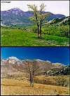
In summer of 2003 fire caused by lightning erupted and consumed part of the pine and beech forests. Thankfully wind from south pushed fire towards Malo Rujno which is only grassy and saved Veliko Rujno from total disaster and spread of fire towards Paklenica valley.
Unfortunately there is no hut or refuge on Veliko Rujno. Closest refuge is on Zavrata field, almost 2h from the center of Veliko Rujno. Across Veliko Rujno goes VPP or Velebit long distance trail on the way from Stap towards Struge plateau and highest peaks group.
 |  |  |  |  |
Malo Rujno (800m)
44°22'18.16"N, 15°23'18.00"E (approximate center)Malo Rujno (malo = small) is smaller part of largest plateau on Velebit, Rujno, which is 7km long and 1.5-2.5km wide. It is placed on the seaboard terrace which runs almost along whole Velebit and looks like a large step on the way from the sea towards high part of Velebit. Malo Rujno is around 3km long and 1km wide. As Veliko Rujno it is closed from all side. On the SE is Rujanska Kosa, a 100m high hill which was moraine of a glacier that descended from Ribnicka Vrata pass (1250m). From SW it is closed by Zvirjak group. On the W is Pricatrnja Polje field which is extension of Malo Rujno. Towards NW seaboard terrace gradually ascends in many steps towards Stap area, which is strewn with beautiful meadows at the bottoms of their basins. They are described bellow. From N to E above Malo Rujno dominates 650m higher Vilinski Kuk (1401m) – Buljma (1420m) – Calopek (1414m) ridge that is separated from Viserujna by Ribnicka Vrata pass.
On Malo Rujno there is no forest. It is completely open with some scattered lonely trees. As on Veliko Rujno, diagonally across the field runs the bed of Kozjaca creek that used to take water of Ribnicka Vrata glacier towards the sea. Over Pricatrnja Polje and Zavrata fields it reaches the edge of seaboard slope and begins to descent. On the way down there are some small gorges while mouth of Kozjaca above sea is almost a small canyon with wild rocky sides. Around the field there are few scattered houses that are slowly turning into ruins. Those were used during summer, till 50 years ago, when people used to guard thousands of cattle.
Over Malo Rujno goes VPP on the way from Stap towards Veliko Rujno and Struge plateau.
 |  |  |  |  |
Vilinski Kuk (1401m)
44°23'8.42"N, 15°23'24.32"EVilinski Kuk is one of peaks that dominate above Malo Rujno. If you are staying in Zavrata refuge it is worthy goal with fantastic views towards sea & Velebit, with bird’s perspective views down on all the fields described on this page. Summit is rocky dome that falls towards Rujno with cliffs which look like pillars. Access is not marked but orientation is not a problem. You cross the Malo Rujno in the direction of grassy slope right of the summit. Ascent is steep and once on top of the grass you are behind the peak from where you climb it, finding the way between rocks and boulders (2.30h from Zavrata refuge, 1.30h from foothills at the edge of Malo Rujno).
 |  |  |  |
Bobicki Kuk (1425m)
44°23'29.96"N, 15°22'46.09"EBobicki Kuk is higher, bigger and more striking NW neighbor of Vilinski Kuk. It is placed above Duboki Dol over which it rises almost 800m. Its summit pyramid is made of broken cliffs, of which some are overhanging. Towards NW it sends long and wild broken ridge that descends to Jelovacka Vrata pass (1150m). As from Vilinski Kuk view similar which means fantastic, especially towards sea. Another similarity is that both are not marked and don’t have paths. It is hard to tell which is better but Bobicki Kuk is tougher and wilder. It is best to combine both in daily trip from Zavrata refuge.
From Zavrata refuge head towards Malo Rujno and Stap. Between Malo Rujno and Carabusa, on the way towards Stap, there are 3 small pass. It is best to turn right close to second pass, at the point where you notice that mostly rocky terrain changes into one predominantly covered with soil. Change is so obvious and it happens just behind the mark drawn on sharp rock which is overhanging the path (1.10h from Zavrata). From there turn sharply right, heading straight up steep W slope of Bobicki Kuk. Here there is much more soil and terrain is softer. If you turn right before you’ll encounter very rough rocky terrain. Aim towards pass which is placed right by the cliffs of summit pyramid. Lower parts of the slope are under oak, maple and hornbeam trees while further up beech is predominant. Once on the pass you have to climb steep summit pyramid. Of three gullies choose first from the left (right one is where burned fir tree is). Climbing lasts some 20mins, 3h from Zavrata.
Between Bobicki Kuk and Vilinski Kuk is large forested basin. To continue towards Vilinski Kuk use seaboard edge of the basin.
 |  |  |  |  |
Pricatrnja Polje (750m)
44°22'10.77"N, 15°22'25.56"E (approximate center)Pricatrnja Polje is rounded field that has around 1km in diameter which lies W of Malo Rujno and is its natural extensions. It is completely flat and grassy without trees, except one sweet little oak on the SW edge towards Zavrata. Field is surrounded by various groups of rocky cliffs which are part of so called first step of Velebit, except towards Malo Rujno. In that direction Bobicki Kuk (1425m) & Vilinski Kuk (1401m) dominate the view. Along the SE edge of the field is dry bed of Kozjaca creek.
 |  |  |  |  |
Zavrata (700m)
Zavrata refuge: 44°21'37.53"N, 15°22'36.15"EField center: 44°21'33.91"N, 15°22'42.95"E
Zavrata field is placed around 1km SW of Pricatrnja Polje field and is its extension towards the sea, as Pricartnja Polje is of Malo Rujno. Zavrata is around 1km long 700m wide. 5m deep dry bed of Kozjaca creek splits it in two parts (more about Kozjaca in Malo Rujno section). Part SE of Kozjaca bed is large grassy field without trees while NW section is combination of meadows and oak & hornbeam groves. At the edge of one such meadow Zavrata refuge is placed, among the ruins of what was once Pregrada hamlet. Zavrata is closed from all sides by the rocky peaks of the first step of Velebit, except towards Pricatrnja Polje and narrow passage towards the sea. On the SE is Zvirjak (929m) group. Cebinac (832m) is on the NW while towards sea it is closed by Vodena Glava (751m). Most interesting is nearby lonely monolith Podgrizen, which is placed between Zavrata and Pricatrnja Polje.
Because of refuge and water cistern by it Zavrata is great place to make a base and explore the beauties of South Velebit’s seaboard terrace.
---------------------------------------------------------------------


Scenes from the Zavrata coastal approach
---------------------------------------------------------------------
 |  |  |
Duboki Dol (630m)
44°22'38.51"N, 15°21'48.19"E (approximate bottom)Duboki Dol is placed NW of Pricatrnja Polje, from which is divided by rocky peak Borina Glava (830m). As the name says Duboki Dol is quite deep (duboki = deep). Rounded grassy field which has 600m in diameter is settled at the bottom of 2km wide rounded basin. On the SW is dome shaped Jovin Kuk (954m) cliff while on the NE Bobicki Kuk (1425m) towers 800m above. Duboki Dol is typical depression of seaboard terrace that is placed between peaks of first step and main ridge of Velebit. It stands out of marked paths but VPP trail passes above it on the way from Stap towards Rujno with nice view at its grassy bottom.
 |  |  |  |
Racabusa (900m)
44°23'19.21"N, 15°21'45.99"ERacabusa (read Rachabusha) is placed at the half way point between Stap and Veliko Rujno. Its meadows are not placed in basin like other fields and meadows of the area, Racabusa is large terrace, some 300m above Duboki Dol on the slope below Jelovacka Vrata pass. N of Racabusa is massive Golic (1424m) while on the E is Bobicki Kuk (1425m). Between them is mentioned Jelovacka Vrata (1250m) pass, once an very important passage towards inner Velebit. Today on Racabusa few houses are still preserved, remnants of former life. Owners of those houses still climb from the coast, from spring to autumn, to cultivate soil and plant some vegetables, primarily potatoes.
Meadows of Racabusa are particularly beautiful in last half of May when nature is fresh green and there are lot of flowers.
 |  |  |
Medeni Dol (750m)
44°23'8.67"N, 15°21'41.09"EMedeni Dol is smallest of basins in the area but as the name says it is very sweet (honey basin). It is squeezed between Duboki Dol and Carabusa. Corner of this few hundred meters long meadow is still cultivated as it is on Carabusa.
 |
Bili Sinokos (720m)
44°22'58.52"N, 15°20'44.80"E (approximate center)Bili Sinokos lies one step below Medeni Dol and is not placed on seaboard terrace but lower, on the seaboard slope of first step. 1.30h below is Ljubotic, starting point to visit Stap. Bili Sinokos is quite large field, almost 1.5km long and around 500m wide. It is surrounded by rocky peaks of first step. During summer months sheep & cows are still on pasturage here, one of rare spots along Velebit.
Hike Advices
This is always toughest section to write, especially when there are so many possibilities. But because of that very reason this section is important especially for those that never before visited the area. It is very tough to climb Viserujna in one day from the coast and descent back so I’ll exclude daily combinations. If you just want to visit Rujno in a day it is best to climb from Milovac or Sibuljina and return the same way. Nice daily combination, just to visit Veliko Rujno, is to climb from Milovac and descent via Aptovac to Cavici, which is just 500m from Milovac, where you’ll leave your car. Combinations presented here are only drop in the sea of possibilities. They are only for those in good shape because routes are long and have huge altitude differences so are quite tiring, doable only during long days. Hiking on Veliko Rujno
1) Viserujna Circle
Combination A: reach Zavrata refuge from Sibuljina in the afternoon (2h). On the 2nd day do the Viserujna loop (whole day). On the 3rd day go towards Stap and visit Kamena Galerija. From Stap descent immediately to Ljubotic or do it on the 4th day (route description on Stap page). If you are in the group with two cars, leave one car in Ljubotic, starting point to reach Stap. If you are alone hitch-hike from Kruscica to Sibuljina or wait for the bus or even walk (3km).
Combination B: Start early from Sibuljina. Cross Viserujna and from Buljma pass reach Struge refuge (whole day). On the 2nd day continue towards Vaganski Vrh and Sveto Brdo (6h). From Sveto Brdo descent to Vlaski Grad to sleep over (1.30h). On the 3rd day via Ivine Vodice descent towards Paklenica hut (3.30h) and continue further to Starigrad Paklenica on the coast (2h). Here take a bus to Sibuljina or hitch-hike. If you are in the group with at least two cars leave one in the Velika Paklenica canyon or in the Starigrad before departing (route descriptions on Vaganski Vrh & Sveto Brdo pages). This is beautiful combination during which you get to see Rujno, Viserujna, two highest peaks of Velebit and finally Velika Paklenica valley and canyon, highly recommended!
2) Extended trip
This is quite long distance combination, probably the best on South Velebit, during which you’ll visit Stap, Rujno & Paklenica areas. On the 1st day start from Ljubotic and reach Stap. From Stap continue towards Rujno and visit Kamena Galerija on the way. After reaching Malo Rujno turn right towards Zavrata refuge where you’ll sleep over (whole day, routes described on Stap page). For the rest of the trip see Combination B above. Difference is slight. You start from Zavrata refuge on 2nd day and spare 2h needed to climb from the coast. When you descent to Starigrad you’ll have to hitch-hike or wait a bus to Kruscica. If you are in group with at least two cars leave one in Velika Paklenica or Starigrad before departing towards Ljubotic.
 |  |  |
Getting There
How to reach each trailhead is described with each route. Center of the region is nearby Starigrad Paklenica from which trailheads are up to 10km away.By Plane
Closest airport is in Zadar, 45 km away. There are no international flights to Zadar (except charter flights during summer season) so you have to go over Zagreb international airport. There are everyday flights from Zagreb to Zadar except on Sunday. They are usually in the evening, around 20h. Find more info about flights on official site of Croatia Airlines
By Bus
There are numerous bus lines from Zagreb to Zadar each day, almost every half hour. The only problem is in the fact that there is no direct bus to Starigrad Paklenica from Zagreb. Some lines go via highway some use road via Gracac. Those that go via highway don’t stop on Maslenicki Most bridge location so from Zadar you have to take bus back towards Rijeka. Those that go via Gracac stop on Maslenicki Most bridge. Wait there for the bus towards Rijeka or you can hitch-hike to Starigrad Paklenica, which is 15 km from here. Of course, if you are going on Velebit immediately you’ll ask driver to stop where your trailhead is.
Detailed bus timetables you can find at Zagreb bus station site.
By Train
Train is not a good option if you are coming from Zagreb. It travels longer than bus and you have to change the train in Knin towards Zadar and than take a bus to Starigrad Paklenica. Train timetables can be found on Croatian railways site.
By Car
The best way is to come by car. There are two main directions to come to this area, from Rijeka or Zagreb.
From Rijeka, along the coast
This route is suitable if you are coming from western Europe, via Trieste (Italy).
Trieste - Rijeka 70 km
Rijeka - Starigrad Paklenica 180 km
From Zagreb
This road is suitable if you are coming from eastern or central Europe via Ljubljana (Slovenia), Maribor (Slovenia) or Budapest (Hungary).
Ljubljana - Zagreb 138 km, Maribor - Zagreb 113 km, Budapest - Zagreb 347 km
Zagreb - Starigrad Paklenica (via Plitvice and highway) 250 km
From Zadar
Zadar – Starigrad Paklenica 45km
Look for current road conditions in Croatia on the page of Croatian Automobile Club (HAK)
 |
When To Climb
Find out more about Velebit climate on Velebit main page. When to climb depends of your skills and wishes. Viserujna is climbable during whole year.Winter lasts from November to end of April. Crampons are always necessary in this period. Also is ice ax because on northern slopes snow is usually hard packed. Viserujna has harsh climate of high Velebit so good forecast is essential. Most dangerous factor is Bura wind which reaches hurricane force on Velebit, especially on passes and summit ridges. Easiest way to climb Viserujna in winter is from Paklenica via Buljma pass, especially if you sleep over at Struge refuge. Ascent from Rujno via western ridge, which is highlight of this page, is tough during winter because of steepness and length.
Summer on Viserujna is compressed in July and August. On Rujno there is little shade while on Viserujna long summit ridge there is none. Summer is worst time of year to visit, especially August when it is quite hot.
Autumn months are September and October. September is already fresh on Viserujna and in last third of month autumn colors begin to appear. It is not strange if snow falls even at the end of August but it won’t remain long on the ground till the end of October, which is one of most beautiful months during the year to visit because of amazing colors. But while autumn colors are in full swing on Rujno in the second half of October, leafs are already gone on Viserujna.
Spring months on Viserujna are May and June. Then everything is fresh, fluorescent green with lot of flowers. By the end of June it is already hot.
 |  |  |
Mountain Conditions
Conditions on Velebit are very well known thanks to Zavizan meteo station, which is observing weather since 1953. There is no weather forecast for Velebit on the net, only current data. Zavizan is at similar altitude as Viserujna so temperatures are the same. For the forecast look at places which lie close to this area of Velebit like Gospic & Zadar.Here are the links where you can find out about the current weather on Velebit (Zavizan) and forecast for Croatia:
WeatherOnline:
WeatherOnline home page
Croatia at WeatherOnline,
Zavizan at WeatherOnline
Croatian Meteorological and Hydrological Association (DHMZ):
DHMZ home page
DHMZ Forecast page
DHMZ 7 Day Forecast for Croatian cities and places World wide, including Zadar & Gospic
Current Weather Conditions in Croatia including Zavizan, Gospic and Zadar
Snow Depth's in Croatia
 |
Objects
Zavrata (720m) refuge is placed in a small rocky house that was given by owner to Paklenica club from Zadar on considerable period of 25 years to be used as refuge with extension possibility. House has two rooms, kitchen & sleeping room, and is placed in what used to be Pregrada hamlet. Now around are just rocky ruins that remind of former life on Velebit. Around the house are beautiful meadows and small groves of oak and hornbeam. Just by the refuge are two wells with good water that doesn’t have to be cooked or disinfected by chlorine tablets. Refuge can accommodate 10 people comfortably but in need even more.Other closer refuges are Tatekova Koliba on Stap (info on Stap page, 2.30h from Zavrata). In Paklenica direction there are two objects: Struge refuge on Struge plateau (3h from Zavrata) & Paklenica hut in Velika Paklenica valley (4h from Zavrata). Info for both objects is on Vaganski Vrh or Liburnija pages.
 |
Camping & Accommodation
Camping inside the national park is forbidden. But, of all places described on this page only Viserujna is inside National Park. This is area of huge grassy fields and meadows so there are so many places to erect a tent. Best place is certainly near the water which can be found near Zavrata refuge on Zavrata field or by the church on Veliko Rujno, which is at the center of the field. If you want to camp at the coast before or after visiting Velebit there are dozens of camps on the coast in the Starigrad Paklenica and Seline. Many are concentrated around the entrance in the Velika Paklenica. Also there are Alan, Rajna, Vicko, Kiko hotels etc. in Starigrad Paklenica and many private apartments in both places.More info on accommodations you can find on Starigrad Paklenica Riviera site.
Red Tape
Viserujna is inside the Paklenica National Park but you pay only at the entrance to Velika Paklenica, which is 30 Kuna (4 Euro or 5 Dollars). One ticket is worth for two entrances or one entrance with visit to labyrinth bunker in cliffs of Velika Paklenica or Manita Pecina cave. In Velika Paklenica there is no extra fee on parking. If parking inside the canyon is full they will tell you on the entrance to leave the car there. In that case minibus will take you there without extra fee. You don’t have to pay if you are accessing Rujno or Viserujna via any other route.More information about prices can be found on Paklenica National Park site.
Other Velebit pages on SummitPost
~ Velebit massif, main page~ Zavizan area, North Velebit (Mali Rajinac (1699m) highest peak on the page)
~ Rozanski Kukovi group, North Velebit (Gromovaca (1676m) & Vratarski Kuk (1676m) highest peaks on the page)
~ Alancic / Rozanski Vrh / Seravski Vrh, North Velebit (Goli Vrh (1670m) highest peak on the page)
~ Veliki Kozjak (1629m), North Velebit
~ Satorina (1624m), Mid Velebit (including whole area between it and Alan pass)
~ Stap area, South Velebit, (Debeli Kuk (1269m) highest peak on the page)
~ Visocica (1619m), South Velebit
~ Bojin Kuk (1110m), South Velebit
~ Paklenica area, South Velebit
~ Vaganski vrh (1757m), South Velebit (highest peak of Velebit)
~ Liburnija (1710m), South Velebit
~ Sveto Brdo (1751m), South Velebit
~ Tulove Grede (1120m), SE Velebit
~ Crnopac (1404m), SE Velebit
Note: Text on this and pages above is copyrighted and cannot be used in any kind of publications.