
-
 5320 Hits
-
 83.69% Score
-
 17 Votes
|
|
Mountain/Rock |
|---|---|
|
|
49.17115°N / 7.84544°E |
|
|
Hiking, Sport Climbing, Toprope, Bouldering, Scrambling |
|
|
Spring, Summer, Fall |
|
|
328 ft / 100 m |
|
|
Overview
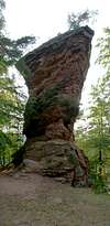
 Kleiner Stephansturm Kleiner Stephansturm |
Climbing in the Südpfalz area can be a crowded affair, especially if you plan to climb one of the cliffs, which are located close to the main highways (like Drei Felsen) or one of the crags in the town centers (like Hochstein or Burghaldefels in Dahn or Hauenstein respectively). However, if you are prepared to lug your ropes around for a moderate distance (less than 5km) you can find solitary spots where you don't have to make a reservation beforehand. Moreover, the number of established routes on these cliffs is far smaller so that you can pioneer a fa yourself.
Four of these remote crags are located to the south of Hauenstein at the end of the narrow Stephanstal. 2km south of the closest parking lot ttwo sentinels look over the entry of a very narrow side valley, stretching off to the east of Stephanstal. The northern sentinel in reality is composed of two towers, Großer and Kleiner Stephansturm. Both towers are separated by a narrow gap with Kleiner Stephansturm - a narrow needle-like spire located on the valley side. The higher and larger Großer Stephansturm is located west of the gap. Both towers have vertical north faces while on the southern side you find several large steps with wide ledges in between. Also, the south faces are far more structured so that here the climbing routes are far easier than on the northern side.
|


The southern sentinel, Wolfsfelsen, though less important in terms climbing, shares the same structure: smooth vertical north face and a structured south face with ledges in between. the Wolfsfelsen summit is slightly overhanging to both the south-east and north-east. Right to the east of the summit and barely 20m beneath it there is a hiking trail , which connects Erfweiler with Hauenstein and which makes te crag a popular object for photography.
|


The narrow valley between Stephanstürme and Wolfsfelsen leads up to a saddle to the north of which the third crag, Sattelfelsen or Dümpfelturm, can be found. It is a rather small piece of rock, which is hidden deeply in the pine forest. You can only see it when you are already very close. Also, it is the least important climbing destination of the four. But that is more than made up for by the bizarre aspect of Sattelfelsen. Its summit ridgeline is filled with mushroom shaped formations, complete with holes and windows. Some of these form impressive overhangs over the Sattelfelsen west face.
|


Both the Stephanstürme and Wolfsfelsen have been climbed very early in the exploration and climbing history of the Wasgau region. The Stephanstürme summits were first climbed by Friedrich Jung, August Bauer and Karl Petry in 1908 while the Wofsfelsen summits were both climbed by Theo Mann, Jakob Otto and Adrian Platz at Christmas 1912. For some additional climbing shots see this page
Climbing Routes
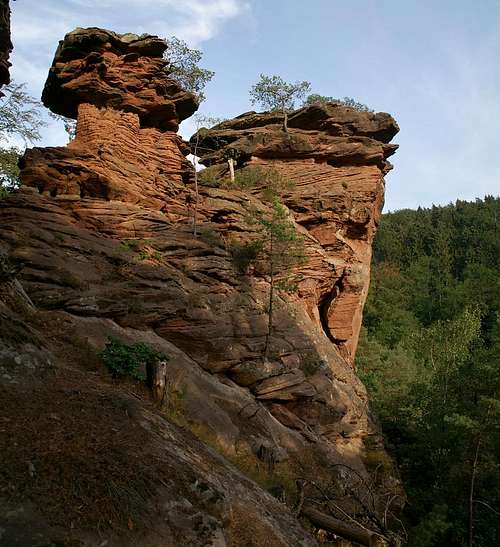 Sattelfelsen summit structures
The following information is linked from the site of the Vereinigung Pfälzer Kletterer I link to their routes database directly with some summary info. Here is the link t the complete database.
| Region | Routes link | Summary |
| Stephanstürme | Stephanstürme | 21 routes with variations ranging from 2 - 9/9+ |
| Wolfsfelsen | Wolfsfelsen | 6 routes with variations ranging 2 - 8- |
| Sattelfelsen | Sattelfelsen | 2 routes with rated 1 and 7- |
Getting There
 Sattelfelsen summit mushrooms
Sattelfelsen, Wolfselsen and Stephanstürme are located south of the town of Hauenstein. From the town centre a sign leads to a large parking lot to the west of the Burghalde cliff. Hauenstein itself, though close to the access road B10 is hidden from view by the Neding- (also a climbing cliff) and Mischberg mountains. The closest airports are at Frankfurt and Stuttgart so the itineraries start there too.
From Frankfurt
There are two possible routes which both take equally long- Via Ludwigshafen
- From Frankfurt take motorway A5 southward to Darmstadt.
- There change to A67 south.
- At Viernheimer Dreieck turn onto A6 west. Leav
- e it at Frankenthaler Kreuz for A61 south.
- At Mutterstädter Kreuz take A65 south until you reach Landau.
- At Landau turn on B10 west.
- Take the exit Hauenstein after you have passed Wilgartswiesen.
- In the town centre turn right for a marked parking lot (look for signs).
- Via Kaiserslautern
- From Frankfurt take motorway A3 west
- At Mönchhofdreieck turn onto A67 south
- At Rüsselsheimer Dreieck take A60 west
- At Kreuz Mainz Süd take A63 south
- At Kreuz Kaiserslautern turn onto A6 west
- At Kreuz Landstuhl turn onto A62 south
- At Pirmasens turn onto B10 east
- Take the Hauenstein exit
From Stuttgart
- Take motorway A8 to Karlsruhe
- At Karlsruher Dreieck turn north onto A5
- Take the next exit to head for A65
- At Landau turn on B10 west.
- Take the exit Hauenstein after you have passed Wilgartswiesen.
Red Tape
Yes, there is red tape and lots of it. The sandstone of Südpfalz forms lots of caves and overhangs. Though this makes it most interesting for climbers, two species of birds of prey compete for this habitat: the peregrine falcons and the eagle owls. Both are endangered and wherever there is a eagle owl pair found nesting in the sandstone the crag will immediately be closed. Generally this closure lasts from the beginning of each year through Aug. 1st. If breeding is not successful the closures will be cancelled even before that date. For a list of closures see the Closure List of PK.The use of magnesia is not allowed in the whole Südpfalz region. This is rather a directive or an arrangement than an outright law. Thus you probably will get away with using it but do so only when absolutely necessary. Magnesia closes the pores which you find in the sandstone and together they form a smooth surface which will get very slippery in wet conditions. The rule of thumb is to use magnesia in the highest difficulty sections and only extremely sparingly.
A list of guidelines can be found here (in German).
Accommodation
In Hauenstein you can find quite a number of hotels and apartments. There are two websites, the firs of which gives a very good overview over any sort of accommodation (visit the link "Unterkunft".Besides from being the "secret climbing capital" Hauenstein is the "shoe capital" of the area due to its long history of shoemaking.
Weather Conditions
Hauenstein has its own weather forecast at weather.com:- Hauenstein weather
Maps & Books
Maps
As for maps there is a good overview map (1:50000) by Kompass Verlag but the best ones are the official topographic maps by the state government of Rheinland Pfalz, scaled 1:50000, 1:25000 and 1:5000. All official maps can be found on the web page of Landesvermessungsamt Rheinland Pfalz
1:50000- Naturpark Pfälzer Wald
Kompass Map WK766
ISBN: 3-85491-523-3
- Bad Bergzabern
LVA RLP Map L6912
ISBN: 3-89637-194-0
1:25000
- Naturpark Pfälzer Wald
- Bad Bergzabern, 6813, ISBN: 3-89637-148-7
Books
There are a number of climbing guidebooks on the region of Südpfalz. The best ones, however, have been published privately and are sold only in selected bookshops of the region.- Hiking
- Pfälzerwald
B. & J.-Th. Titz
Rother Verlag
ISBN: 3-7633-4268-0 - Klettern im Buntsandstein
U. Daigger, H.-J. Cron
Published privately and out of print
- Pfalz ++, Klettern im Buntsandstein
R. Burkard, P. Weinrich
Published privately
- Klettern im Naturpark Pfälzerwald
Naturfreunde Lambrecht
Published privately - Pfalz & Nordvogesen en bloc
A. Wenner, Y. Corby, I. Bald
Panico Verlag
ISBN: 3-936740-19-4
Climbing
- Pfälzerwald