
-
 6833 Hits
-
 83.69% Score
-
 17 Votes
|
|
Mountain/Rock |
|---|---|
|
|
44.96835°N / 109.46498°W |
|
|
Mountaineering |
|
|
Summer |
|
|
11029 ft / 3362 m |
|
|


Overview
If you are driving the Beartooth Highway from west to east, you will, shortly after passing what is called the West Summit, drive by "Stockaid Peak." Stockaid BM is the highpoint of a plateau-like mountain up and around which the Beartooth Highway winds, and Beartooth Pass is along its flanks. (Beartooth Pass is sometimes thought of as being on the Montana-Wyoming border, but it is actually entirely within Wyoming). Unless you are reading a topo map as you are driving by the peak (not a great idea on this sinuous road), you will never know you are passing anything more than a bump on the tundra until you are past the peak and you see its dramatic eastern face. (On the other hand, if you drive from west to east, you will see this face, gawk at it, and wonder what in the world happened to it as you cross the rolling tundra around the pass.) This eastern face, known to some as the Gardner Headwall, has a steep couloir that holds snow all summer long, and it is popular with skiers and snowboarders and makes a nice little climb in an area whose immediate vicinity seems to offer little for climbers.
That couloir is the focus of this page (whether it's actually narrow or inset enough to qualify as a true couloir, I can't say, but the designation will work for this page). Anyone can hike to Stockaid’s summit by getting out of the car and walking about 5 minutes (probably not even that long), gaining a whopping 100’ of elevation, to reach the outcrop that is the summit. That “hike” is not the focus of this page, though. If, however, a fun, challenging snow climb just minutes from the busy Beartooth Highway interests you, please read on.
First, some words about what Stockaid is and is not-- Stockaid is not a mountain you climb for the views. That is not to say the views are not spectacular, because they are; it is just that Stockaid's only "views advantage" over the Beartooth Highway running along its flanks is that it serves up all those views at once, so if it's just views you seek, it's easier and more comfortable to stay in the car. Also, Stockaid is not a peak in the heart of the wilderness; even when you are deep and high into the couloir, you will see and/or hear motorized traffic, and part of the summit view is the Beartooth Highway.
What Stockaid is, though, is a nice climb in an awesome setting and without the one- or two-day approach characteristic of most other Beartooth peaks. It is also an escape from the bustle of the Beartooth Highway; although, as noted already, the sight and/or sound of traffic will almost always be present, you will be a relative world away from all of that once you step up and into the couloir. Finally, those blessed (or perhaps cursed) with an addiction to the spirit and the magic that is Greater Yellowstone will find a quick fix for the habit as they pause along the climb and stare deep over the Southern Beartooths and into the wild, wild Northern Absarokas, a land where dreams and egos are both made and smashed. Those with this bug know there is no escape and are glad of it.
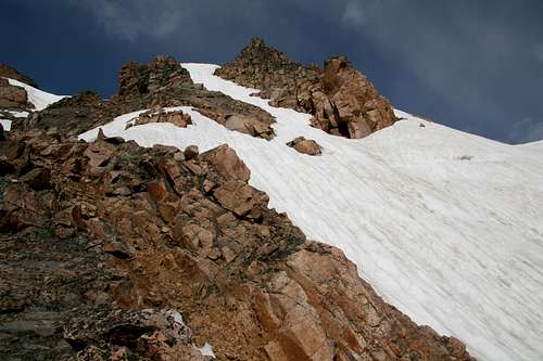
Stockaid’s cliffs and couloirs rise steeply for about 1000’ from the shores of scenic Gardner Lake, which is seen by many but visited by far fewer even though it is a short, albeit steep, hike from the road. The snow in the couloir discussed here still reaches the lake even in July, and it ends at about 10,900’, so a summer climb will feature 800-900’ of climbing moderate and steep snow. Some rock islands in the couloir offer the chance to mix things up with some Class 3 and 4 terrain. The walls lining the couloir look technical, but that does not mean there is no non-technical way up them. People interested in climbing Stockaid from the lake without dealing with the snow and the harder scrambling can find talus slopes near the southern end of the lake that will offer Class 2 (and maybe 3) going.
Basic Details and Summary of Route Options
The distance to the summit from the Gardner Lake TH is about 1.5 mi, and the distance back to the TH is about 1 mile. There is an initial elevation loss of 500’, followed by a climb of about 1100’, almost all of it in the couloir. There are three route options, and each involves a minimum of 500-600’ of climbing moderate and steep snow. The first is to go left at the first rock island. The second is to go right. The third is to mix snow and rock on this climb by using one or more of the rock islands. Certain photographs on this page show the options, plus some possible variations, and the routes are easy to study from the trailhead.
Climbing Details
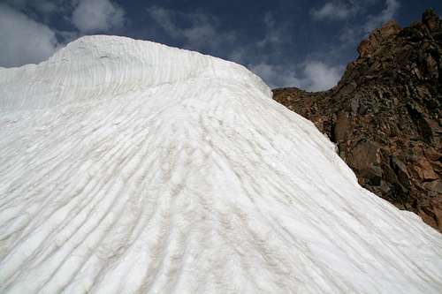
There is really not a great deal more to say about climbing the couloir. It starts at a moderate grade and then gets progressively steeper toward the top, where you will likely have to climb or bypass a vertical headwall of snow that when I was there was about 8 feet high. (I climbed it, not liking the bypass option that I had.) I cannot attest to conditions throughout the summer or speculate what average conditions are here, but when I climbed here, much of the snow was hard to the point of being icy or at least difficult to kick-step into and drive the shaft of an ice axe into; I had spent the previous two days on mostly soft snow in the Gallatins and decided to leave my crampons in the car when I climbed Stockaid, and I quickly was wishing I hadn’t done so.
Because I didn’t have my crampons, I decided to try the rock islands in order to make the climb a little safer and more varied. The first rock island is at about 10,600’ and separates the couloir into two distinct sections; to the left, it gets narrower and very steep, and to the right, it stays somewhat broad and remains steep but not as steep as the other side. There might have been an easier way up and through the rock island, but I found mostly Class 3 with some short Class 4 sections. From the top of the island, I climbed a short stretch of snow to another island, which led me to the final snow slopes and to the headwall. It was my wish to finish the climb on snow, but had I not wanted to, there was a third rock island I could have crossed to, and that would have taken me to the summit area snow-free.
Once up top, look off to your left for an outcrop that looks like the highpoint. You’ll find a “Stockaid” USGS benchmark up there, but no register, and you’ll have a full view of the Beartooth Pass area, including the road. Follow the ridges and slopes, not the road (though sometimes you will be next to the road), back to the parking area, unless you want to ski or glissade back down the way you came (the steepness of the route and the hardness of the snow could turn a glissade extremely dangerous, but you make the call). Remember that going back down the way you came will entail a 500’ elevation gain back to the car.
Gear to bring: Ice axe and crampons.
For your additional safety: When you are near the top of the couloir, skiers about to descend may not be able to see you, so call out to alert anyone who might be up there to your presence.
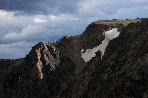
Stockaid BM and Approaching Storm
Weather
Weather in the Beartooths is infamous for changing rapidly and dramatically, more so than in many other mountain ranges. Do not let your proximity to the road and your car fool you; if a storm moves in and breaks, you are in bad place out here. Do not commit yourself to this climb unless if conditions look even a bit iffy.
Getting There
The trailhead for Gardner Lake is between the Montana state line and the East Summit of the Beartooth Pass area, on the south side of the road. It is a large parking area with a sign indicating the Beartooth Loop National Recreation Trail and the Gardner Lake Trailhead. It takes a special kind of talent to miss this parking area. From the parking area, which is at around 10,600’, hike ¾ mile downhill to Gardner Lake, at 10,000’.
The Beartooth Highway opens in late spring and closes in early fall (typically around Memorial Day and the first week of October, respectively, and motorized access in winter is by snowmobiles only), though the particular year's conditions may speed up or delay the opening/closing. If visiting during those shoulder periods, it is best to check on road status ahead of time. This site has general information about the road and has links and phone numbers for finding out about current road conditions.
Red Tape
No official red tape. Try to minimize your hiking on the tundra around the lake. Mosquitoes like Gardner Lake. A lot.
Camping and Lodging
There are many campgrounds along the Beartooth Highway. The closest one is at Island Lake, west of the trailhead and about a 30-minute drive away. Expect this campground to fill on holidays and weekends, so arrive early.
Only a short distance west of Island Lake is Top of the World Resort. This property has a store, campground, and motel rooms (only 4, so reservations are strongly recommended.
Cooke City and Red Lodge have several motels and lodges. Red Lodge is larger and has much more of a selection. Some of the motels are franchises of national chains and accept online reservations.
Some Useful (Hopefully) Route Photos
Please click and enlarge for details.
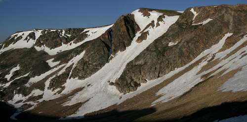
The whole thing
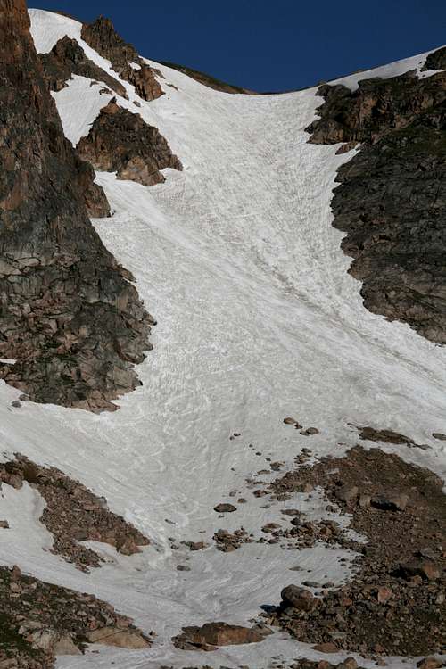
Time to go up...
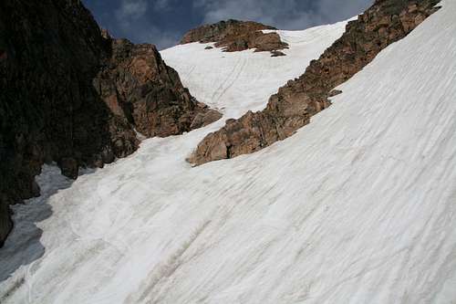
A key section
Rock Islands
The End