
|
|
Mountain/Rock |
|---|---|
|
|
46.23044°N / 8.16902°E |
|
|
Piedmont |
|
|
Hiking, Skiing |
|
|
Spring, Summer, Fall, Winter |
|
|
7825 ft / 2385 m |
|
|
Overview
The summit of Monte Teggiolo is the Eastern end of the big ridge that from the top of Monte Leone(3495m) descend to the village of Varzo, dividing the valleys of Cairasca and Diveria rivers.Toward SE Teggiolo hangs over Varzo with a prominance of more than 1500 meters, with a precipice carved by narrow gullies covered by savage vegetation.
Part of this precipice is still visible over the smalll village of Bugliaga, under the south flank of the mountain, but the rugged cliffs are here interrupted by meadows that, altough their steepness, house numerous settlements where livestock find feeding during summer.
At North the slopes of the mountain descend gently over Cairasca valley, facing the huge cirque of Alpe Veglia Natural park with meadows and forests.
The normal route along the broad western ridge is a pleasant trail for hiking and ski-mountaineering, with fascinating views over the great mountains of this area such as Monte Leone and the ones of Weissmies group.
On the summit there is an old refuge for hunters that can accomodate two or three sat persons.
 3D map
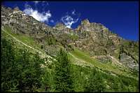


 >
>
Getting There
The trailheads are Bugliaga(1300m), a small locality near the village of Trasquera, on a lovely balcony of meadows above the valley of Diveria River, and San Domenico(1400m), at the end of Cairasca valley.Both these places can be reached quickly by car from the village of Varzo, adjacent to the SS33, the highway that connects Milan and Brig passing by Simplon pass.
If you want you can reach this area also by train, the famous railroad of Simplon with its tunnel passes by the village of Iselle (station), near Varzo, but from there you probably have to travel by Taxi, which could be very expensive, or in alternative you can use a bike, in this last case remember that the distance is around 12-15 Km and the elevation to gain till Bugliaga or San Domenico is higher than 1000 meters.
Huts
No huts are necessary to climb Teggiolo, the normal route is feasable in one day without difficulties.Climbing the summit
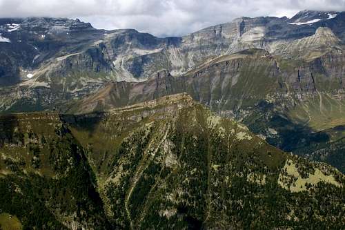 Teggiolo seen from the near Pizzo Giezza
The normal route follows the large dorsal (W ridge) that connects Teggiolo to the Punta di Valgrande.
Starting from Bugliaga you have to follow the trail to Possette Pass, that is the easiest access to the slopes of the large ridge from Divedro valley.
Hiking from Bugliaga it’s a pleasure to gain elevation while the Panorama enlarges toward the narrow Valley of Diveria and the great summits at Its borders.
Once you have reached Possette Pass walk on the W ridge without difficulties till the summit.
If you start instead from San Domenico go on along the paved road by your car or by feet for some kilometres after the village, till the end of the paved road at Nembro.
There You find a parking where the road becomes private and leads to the entrance of Alpe Veglia natural park.
A trail starts from the car-park leading to Alpe Vallè and Alpe le Balmelle, right under the Cairasca side of Possette pass.
From Alpe le Balmelle, without reaching the pass, go on toward the summit approaching the large West ridge by the shortest route.
Here you find just easy and lovely meadows without difficulties or dangers and the View is great.
From both sides the elevation gain is of 1000 meters and the time requested is between 2 or 3 hours depending on your legs. I suggest the trail from Bugliaga and eventually the descent on Cairasca side.
[img:377942:aligncenter:medium:3D map]
Ski-mountaineering
The summit of Teggiolo is often reached also by ski mountaineers.The route from Cairasca valley is always secure and easy, the one from Bugliaga can be dangerous after huge snow falls and is very steep.
External Links
Here after the official sites of the villages of San Doenico and Varzo, with useful informations about the roads, and the accomodation.San Domenico
Varzo
The following sites report instead the description of the trails and some images and maps.
Teggiolo on "alpioccidentali.it
Teggiolo on Cappef.com
[img:377940:aligncenter:medium:Teggiolo seen from the near Pizzo Giezza]