
-
 11114 Hits
-
 83.1% Score
-
 16 Votes
|
|
Mountain/Rock |
|---|---|
|
|
38.78100°N / 104.876°W |
|
|
El Paso |
|
|
Trad Climbing, Sport Climbing, Bouldering, Scrambling |
|
|
Spring, Summer, Fall, Winter |
|
|
6600 ft / 2012 m |
|
|
Overview

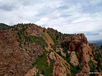
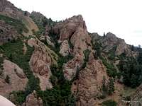
Distinctive summit of "The Pinnacle"
Mount Cutler rises between North Cheyenne Canyon and South Cheyenne Canyon. North Cheyenne Canyon is a relatively narrow passage, surrounded on both sides by steep (often crumbly) spires of Pikes Peak Granite. Select spires in this canyon offer descent climbing very close to Colorado Springs within the namesake Cheyenne Cañon City Park. (Note the city’s use of the Spanish spelling for cañon.) Several climbable spires reside on the lowest northern slopes of Mount Cutler very near to the creek.
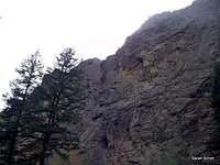
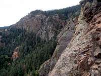
North across the canyon
Due south of Graduation Boulder, which among other purposes serves as a location for high-angle rescue clinics, "The Pinnacle" is a distinctive, double-turretted spire. North Cheyenne Creek roars below and the creek shares the canyon with a narrow road. The summit block is 4th class and this peak could indeed be ascended as a scramble, though most visitors to "The Pinnacle" are there for the rock climbing.
Getting There

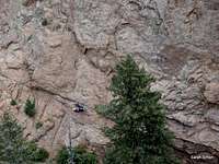
Approximate Location of "The Pinnacle"
Driving Directions

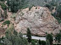
Crossing the stone bridge
There are several different ways to reach North Cheyenne Canyon, depending on your origination location. This crag is accessible to all motorvehicles via a paved road. Here are some straight-forward directions from I-25.
•Take the Tejon Street exit (#140) and follow Tejon west.
•Merge right onto Cheyenne Boulevard, which blends into W. Cheyenne Canyon Road (though you may not even notice).
•At the Starsmore Discovery Center (2120 N Cheyenne Canyon Road), bear right onto North Cheyenne Canyon Road.
•After entering the canyon, drive less than 1 mile to an indistinct pull-out on the right side of the road.
•Carefully cross the road, cross over the creek on a stone bridge, and head uphill roughly southeast to the base of the formation.
"The Pinnacle" sits approximately where the words “White Fir Botanical Reserve” are in this City of Colorado Springs PDF-format map.
Route Information

Park signage
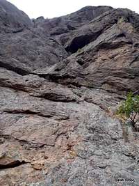
Army Route, First Pitch
Until others on SummitPost post additional route information, here are some route resources.
"The Pinnacle" on Mountain Project
Friends of Cheyenne Canyon
•North Face
•East Face (Sunslabs)
•West Face
You can also refer to my SP photo album with limited descriptions of the 3-4 pitch Army Route (5.5-5.7, depending on opinion) for some information.
Red Tape

Bright red berries

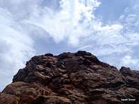
Top of "The Pinnacle"
Park Hours: May 1 to October 31: 5am-11pm / November 1 to April 30: 5am-9pm
Per The Friends of Cheyenne Canyon:
To climb in this or any city park, the City of Colorado Springs requires all climbers to obtain an annual climbing permit. These permits are available, year-round, for free, at Garden of the Gods Visitor Center, 1805 N. 30th Street, 9:00 A.M. to 5:00 P.M., 7 days a week.
 |  |  |
Camping & Lodging
North Cheyenne Canyon
East from Army Route

The Broadmoor
Downtown Colorado Springs
There is no camping available in Cheyenne Cañon Park.
The nearest semi-developed US Forest Service campsites would be in the Rampart Reservoir area.
| Meadow Ridge Campground | Thunder Ridge Campground |
|---|---|
| •19 campsites •9,200 feet elevation •Season: Generally early May through September •$15 per night, per site •Amenities include tables, fire grates, drinking water, latrines, and trash collection | •21 campsites •9,200 feet elevation •Season: Generally early May through September •$15 per night, per site •Amenities include tables, fire grates, drinking water, latrines, and trash collection |
HOTELS
Manitou Springs
Manitou Springs lies at the foot of Ute Pass. This colorful, eclectic town offers a wide range of lodging options including old-style motor cottages and cabins, retro family-run motels, charming B&Bs and modern chain hotels. Shopping and dining are within walking distance of most Manitou lodging.
Colorado Springs
The hotel options in Colorado Springs are virtually limitless. If you are the 5-star luxury type, be sure to check out The Broadmoor.
Weather & Seasons
 |  |  |
 | Due to relatively low altitude, "The Pinnacle" can be a reasonable year-round summit objective, depending on recent weather conditions. Winter: Snow and ice could make routes on "The Pinnacle" treacherous and high winds and cold could just make this crag downright unpleasant, especially for north facing routes. However, the odd warm winter day in a dry weather pattern could make this a neat winter get-away close to home. Summer: In the summer, this is a very popular area for the urban masses. In addition to fellow climbers and hikers you will encounter picnickers, hippies, thugs and just about everyone and everything. Remember, this is a city park! High temperatures mean an early start will reward you with cooler air. Spring & Fall: Spring and fall may be the best time to visit this crag, both for more slender crowds (with the exception of a peak Aspen season) and moderate weather conditions. |  |
 |  |  |