
|
|
Mountain/Rock |
|---|---|
|
|
45.45100°N / 90.1954°W |
|
|
Price |
|
|
Hiking |
|
|
Spring, Summer, Fall, Winter |
|
|
1951 ft / 595 m |
|
|
Overview
At 1,951 feet above sea level, Timms Hill is the high point for the state of Wisconsin, which ranks as the 39th state in order of elevation.
Timms Hill is located in the north central part of the state, near the small town of Ogema, WI. It is only 1 of 2 state highpoints that is located within a county park. (The other is Britton Hill in Lakewood Park in Walton County, FL.)
There are 2 lookout towers guarding the summit. The newer wooden tower is about 15 meters high and easily climbed via stairs for great views looking to the north, south and east. The older steel radio tower is climbed via an exposed attached ladder and rises 22 meters to offer a spectacular 360 degree view above the surrounding tree canopy. For those daring enough, the view is well worth the effort. There is a vertical cable with stops every 20ft that you can tie onto if you bring a climbing harness to add a level of protection while climbing the ladder. The geological survey marker is located under the steel tower.
The summit register and mailbox were recently moved from the Hill of Beans Coffee Shop back to the highpoint lookout tower.
 |
 |
 |
 |
Annual Highpointers Convention
The annual convention of the Highpointers Club was held in Wisconsin near Timms Hill on July 27-28, 2007.
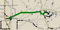
Getting There
From Tomahawk, WI drive 22.2 miles west on State Highway 86 to County Road RR. Turn left (south) onto CR-RR and watch for signs to Timms Hill County Park on the right hand side. Follow the dirt road a few miles until you reach the parking lot for the Timms Hill trail.
From Ogema, WI, take SH86 east to County Road C. Follow CR-C south until you reach County Road RR. There's a posted sign at the junction of the 2 roads that reads, "Road to Timm's Hill County Park 1 mile". Turn left onto CR-RR. Turn left onto the paved road at the signed entrance to the park and follow it until you reach the parking lot for the Timms Hill trail.
The trail to the highpoint gains a mere 140ft over the 1/4 mile distance and is well marked at the parking lot.
 |
 |
Timms Hill County Park
Timms Hill County Park is 220 acres of mostly forested land, with 2 lakes, Timms Lake to the north and Bass Lake to the south. The park contains numerous hiking trails, including part of the Ice Age Trail, 1 of only 8 National Scenic trails in the US.
- Tower Trail - 1/4 mile
- Pearson Lake Trail - 1/4 mile
- Hardwoods Trail - 1 mile
- Timms Lake Trail - 1 1/8 mile
- Bass Lake Trail - 1 1/4 mile
- Ice Age Trail - 1,200 miles
Red Tape
The park gate is normally open from 7:30am until dusk from May through October. There are no pre-set hours in the fall or winter, but you can hike or cross country ski into the park anytime. Admittance is free. There are no permits required. Pets must be under control or remain on a leash at all times.
 |
 |
When To Climb
Timms Hill can be climbed any time of the year. Fall is a particularly beautiful time to visit when the trees are changing color. The roads are not plowed during the winter, however you can park your car near the intersection of Ring School Road and Rustic Road and hike or ski in to the park. Parking in winter may also be available in Highpoint Village with the permission of the owners.
Camping
There is no camping allowed in Timms Hill County Park. However there are plenty of places to camp nearby, and several options for hotels in the area.
There is a list of private campgrounds and nearby lodging on the Price County website.
There are also cabins for rent in the Highpoint Village which is located at the south end of Bass Lake.
Local Conditions
Local forecast for Ogema, WI.
Nearby Attractions
There are plenty of other outdoor activities to do in the area during your visit to the state highpoint depending on the season, including hiking, biking, hunting, fishing, boating, canoeing, horseback riding, skiing, snowshoeing and snowmobiling. The Price County website provides additional information for visitors.
Distance to Rib Mountain is 65 miles.
Distance to the Michigan state highpoint Mt Arvon: 200 miles........ Map it.
Distance to the Illinois state highpoint Charles Mound: 270 miles........ Map it.
Distance to the Minnesota state highpoint Eagle Mountain: 275 miles........ Map it.
Etymology
Origin of state's name: Based on an Indian word "Ouisconsin" believed to mean "grassy place" in the Cheppewa tongue.
Timms Hill is named after Timothy Gahan who owned a logging camp on Timms Lake before Price County purchased the land and turned it into a park in 1983.
Redwic - Jul 7, 2008 12:40 pm - Hasn't voted
Hours of Operation Not TrueThe official website containing information for Timms Hill County Park shows the Hours of Operation (i.e. the hours the park gate is open) as being 7:30 AM - 9:30 PM. However, this is not true. In advance of visiting this HP this past weekend, I contacted the Parks Department and found out the gatekeeper commonly closes the park gate by dusk. In fact, the gate even says "Open 7:30 - Dusk". If planning a visit to Timms Hill County Park and wanting to verify the hours the gate will be open, contact the Parks Department at (800)269-4505.
mtzfamily - Jun 29, 2013 10:20 pm - Hasn't voted
UpdateWe "tackled" this summit on the date of this submission. All roads to the parking area are now paved. The summit register in the mailbox are now at the base of the lookout. We came from Ogema and directions were exact.
Alpinist - Jul 1, 2013 9:50 am - Hasn't voted
Re: UpdateThanks for the updates. I updated the page.
Colin - Aug 11, 2015 5:33 pm - Voted 9/10
AccurateI visited on 8/2/15. All the information was accurate as of that date. The registration log was missing. Not too surprising given the number of people that must visit this place. The road through the park is one way (and quite narrow). The entry is on the western side, i.e., the side closest to Ogema.
gcrain - Jun 8, 2016 7:10 pm - Hasn't voted
Sign leading to trailhead is getting overgrownMy wife and I visited this past weekend (6/5/16). The sign pointing to the Timm's Hill trailhead (and very narrow, one-way road) is getting overgrown. Coming from the Tomahawk direction, the sign/road is just a short ways past Bass Lake and the quaint shop/restaurant there. From the Ogema direction, if you hit the quaint shop/restaurant and Bass Lake, you've gone too far.
larvitar - Sep 12, 2016 12:50 am - Hasn't voted
Not the only state HP in a county parkYou mention that Timms Hill is the only state high point located in a county park, but Britton Hill, FL, is also inside a county park (Walton County's Lakewood Park). One of two out of fifty still makes it distinctive, but not unique.
Alpinist - Sep 12, 2016 8:53 am - Hasn't voted
Re: Not the only state HP in a county parkThanks for the correction! I updated the page.