Approach
![View of the Trap Dike from...]() Trap Dike from Avalanche Lake
Trap Dike from Avalanche Lake![Just a closer look at the...]() Borrowed Photo - 1990 slide
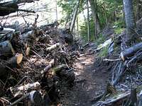
Borrowed Photo - 1990 slide![On the trail to Avalanche...]() Borrowed Photo - Avalanche Debris
Borrowed Photo - Avalanche Debris![The 1999 slide on Colden...]() Borrowed Photo - Avalanche Slab
Borrowed Photo - Avalanche Slab
Kevin and I have been planning to climbing the Trap Dike for quite some time, but either our schedules or the weather didn’t cooperate. Finally, after a couple of years, we had a week without rain, a clear weekend forecast, and a day free to hike.
Before I summarize our hike, a quick geology lesson of the features we’d be climbing would be helpful for those not familiar with the physical history of the Adirondacks. The Trap Dike is a glacier-carved cleft on the western side of Mt. Colden.
The dike is comprised of “soft” rock that had (vertically) intruded between the massive chunks of granite that became Mt. Colden eons ago. Successive glacial advances have worn this rock faster than the hard granite to either side. The result of this erosion is a steep canyon filled with cliffs and waterfalls.
The slides on the opposite side of Mt. Colden were formed differently. After the last glaciers retreated, Mt. Colden was nothing more than a massive hulk of polished granite. Over thousands of years, a relatively thin layer of soil has formed over the mountain. This soil is mainly comprised of decayed organic matter, and is capable of holding a significant amount of water. However, during times of drought, the water evaporates, and the soil dries and contracts. This contracting causes the soil to lose contact with the granite slabs beneath. If a very heavy rain falls when the soil is in this state, the runoff works its way down to the granite slab, where it picks up momentum and further undercuts the soil above. At a certain point, the weight of the soil overcomes the friction of the slab, and the slope gives way. What’s left behind is a granite scar, with a pile of debris at the bottom. Several such slides can be seen on the eastern flank of Mt. Colden, the most recent of which was formed in 1990.
Our plan was to ascend the Trap Dike and adjacent slides to the summit of Mt. Colden, then descend on the 1990 slide. On Friday, John said he’d be interested in joining us, but wasn’t sure his work schedule would allow. Kevin and I were to spend the night at his grandmother’s, and begin our hike from the Adirondac Loj (sic) at 8:00. If John could hike, he would meet us at the trailhead.
The next morning, as Kevin and I were headed up the road to the Loj, a black bear darted in front of my car, then quickly retreated. Kevin wanted to take a photo of the bear, so I stopped on the side of the road. However, by the time he could get out of the car, another vehicle coming up the road startled the bear and he took off into the woods. I found out that it is really hard to see a black bear coming out of a dark forest onto an asphalt road in the early morning hours.
Once at the Loj parking lot, I headed towards the register, and saw John walking towards me. He had made it after all. We donned our packs, and were on the trail at 8:10. I was feeling good this morning, having slept well the night before, and set a quick pace to Marcy Dam. As we approached the dam, we noticed that the water level was low, due to a breach in the dam that occurred earlier in the year. A group that we had passed on the way came running up to us, holding our rope. Note to self: Kevin cannot be trusted with safety apparatus.
We snapped a couple of pictures, and I again set a quick pace to the Avalanche lean-to. We had covered 3.2 miles in exactly one hour, including the time spent at the dam. We rested for a few minutes at the lean-to, and had a well-deserved snack. Just as we were about to leave the lean-to, we met Jason, a student from Paul Smiths College, who said he was planning to solo the Trap Dike.
Up to now, the hiking had been over relatively flat terrain. The next leg of the hike included an ascent of a few hundred feet to an elevated notch, so I slowed my pace a bit. At the top of the pitch, the trail was carved through an 8-foot high jumble of dead trees, while a bare granite slab loomed above. This was a classic Adirondack slide with debris pile at the terminus.
After the slide, we hiked through a thin notch with steep walls on either side. A few minutes later, we reached Avalanche Lake. In my opinion, this is one of the most breathtaking areas in the Adirondacks… a long, thin glacial lake flanked by vertical granite cliffs.
The western “shore” of the lake is comprised of large boulders that had fallen off the cliffs overhead. A series of wooden planks and ladders (called the Hitch-Up Matildas) connects the boulders. Kevin ascended one of these ladders, and I followed closely behind. Too closely behind. As he neared the top of the (approximate) 6-rung ladder, he inadvertently swung his hiking poles towards me. As I shifted my weight back to avoid the tips of the poles, I lost my footing on the wet rung, and my legs fell between the rung I was standing on and the rung below. Fortunately, I only “fell” about one foot, but on the way down both of my shins raked across the rung. I saw stars. My left shin took the brunt of the force, and lost a 2-inch length of skin. I composed myself a minute later, and continued across the Matildas.
We soon reached the far end of the lake, and began hiking down the herdpath along the eastern shore of the lake. I was in an disproportionate amount of pain as my shins were gently grazed by the soft long grass along the path. A minute later we were standing at the bottom of the Dike, where we rested and ate another snack.
Trap Dike
![First step of the Trap Dike.]() First Step of Dike
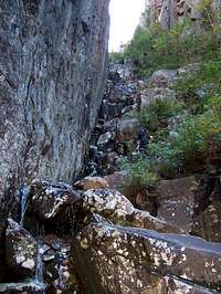
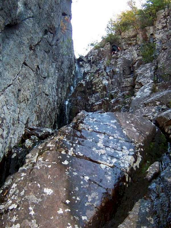
First Step of Dike![The crux of the climb... a...]() The Crux of the Dike
The Crux of the Dike![Typical scrambling in the...]() Above the Crux
Above the Crux![Past the top of the crux (DO...]() "False" Slab after Exiting the Dike
"False" Slab after Exiting the Dike
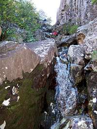
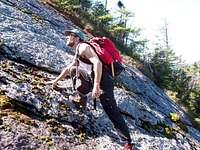
The scrambling began immediately. We ascended a step with a couple of small waterfalls, then a relatively flat section, then another step.
Soon we reached the crux of the climb, a 50-foot waterfall with vertical walls on either side.
The wall to the left was sheer, and was definitely a Class V technical climb. However, the wall to the right was comprised of a series of blocks with a small chimney (crack), and could be ascended without a rope. I ascended to a small 2-foot wide ledge adjacent to the chimney, but couldn’t go higher since I couldn’t reach the next handhold. I looked to the left around the cube-shaped block in front of me, and noticed a thin 4-inch wide ledge followed by a nice flat rock. If I lead with my left foot (to the thin ledge), I’d have nowhere to place my right, and I’d be stuck. So, securing good handholds on the top of rock in front of me, I reached around the rock with my right foot first, and swung my left leg onto the flat rock Given my limited rock climbing experience, I was actually quite proud of this move.
Kevin isn’t overly fond of heights, so he ascended next, with John close behind. Kevin reached the top of the chimney, but had a little difficulty finding the next hand/foothold. However, after a minute of experimenting, he felt secure and climbed onto the 2-foot wide ledge. Unlike me, he was able to reach the next handhold from this ledge, and had a much easier route to the top of the step than did I. John ascended the step on a line between the routes Kevin and I chose. After this crux, the Dike alternated between flat sections and small steps.
After awhile, we reached an area where trees were growing in the Dike, and decided that this is where we should exit the Dike onto the adjacent slides which lead to the summit. After a couple minutes of bushwhacking, I found a slide and began ascending.
About 100 feet up, the slide ended. However, we did see a well-worn herdpath, and figured that this path must lead to the next slide. We were wrong.
The herdpath started to become intermittent, and then disappeared altogether. John continued straight up, Kevin to the right, and I angled between them. After a few minutes, I heard Kevin say he found the slide, so I headed to my right. Problem was, I was walking right into very dense cripplebrush. My shins had already taken a beating from the bushwhacking I had done so far, and by now the nerves were continually firing. The fir tree branches racked across my shins with every step. Even worse is when the stiff broken spruce branches stuck directly into the wound on my left shin. Hiking is sometimes painful, other times it downright hurts… but this was pure agony.
I was finally able to see the slide, but 6 feet of the thickest cripplebrush stood between me and it. I was pushing hard against the branches with my hands (with little result) when another spruce branch stuck me in the shin. I snapped. Like an NFL fullback, I just plowed through the remaining cripplebrush. It should have hurt, but the adrenalin had dulled the pain.
I collapsed on a ledge on the slab. Slowly the adrenalin wore off, the nerves in my shins began firing incessantly. I finally stood up, and walked up to the ledge where Kevin was standing. He said he had found the ledge about 200 feet lower, but John had just continued upward through the brush to the summit. But when I looked up, I saw that John was only 20 feet above me. I then realized that I had pushed through all that dense growth only to come out 20 feet below the summit.
I climbed to the summit, where I had a much deserved sandwich and drink. However, after a couple of minutes, I got antsy and roamed around the summit. On the far side, I was able to get a good view of the 1990 slide.
1990 Slide
![Me standing on a typical...]() Typical Grade
Typical Grade![Yours truly descending one of...]() It's as Steep as it Looks
It's as Steep as it Looks![Kevin at the bottom of the...]() Mid-Point
Mid-Point
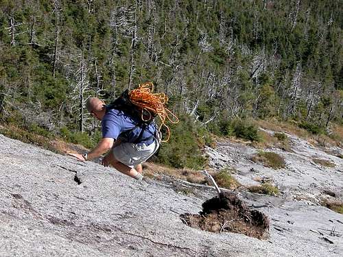
After a few minutes of searching, and taking many false paths, Kevin and John found the herdpath to the slide. I cut over from my position on the summit trail, and within a couple of minutes we were on the top of the slide, and it was VERY STEEP.
I thought about using my rope, but thankfully the rock had an amazing amount of grip. Kevin and John scotched down the steepest sections on their butts. However, since I was wearing trail running sneakers and not high-top boots, I was able to rotate my ankle to match the pitch of the slab and remain upright.
The first 700 feet of descent remained very steep, but gradually the grade eased until we were hiking down what appeared to be rocky stream bank… only one that was 100 times too big for the stream that occupied it.
Return Hike
![Be sure not to stay in the...]() Our "Wrong" Route
Our "Wrong" Route
We soon reached a flat section, where Kevin and I pumped water. John continued down the slide to find the trail that would lead to Lake Arnold. Kevin soon realized that pumping water was a one-man operation, and headed out into the woods to see if he could find a shortcut to the trail. About 30 seconds later he yelled back that he had found the trail. The next five minutes were spent waiting for John to come up the trail. We had a good laugh when he arrived, pointing out that the slide was visible through the trees.
After descending thousands of feet, it was hard to get into “ascent mode” again, and the hike up to Lake Arnold seemed much longer than I remembered. At Lake Arnold, we rested and ate, which seemed to rejuvenate me. Although we weren’t moving as swiftly as we had been in the morning, we set a relatively fast past pace first to Avalanche Lean-To, then Marcy Dam, and finally onto the Loj.
Once at home, we were able to reconstruct where we went wrong.
Comments
No comments posted yet.