
-
 13700 Hits
-
 79.03% Score
-
 10 Votes
|
|
Route |
|---|---|
|
|
41.17659°N / 122.4749°W |
|
|
Hiking, Scrambling |
|
|
Spring, Summer, Fall |
|
|
Overview
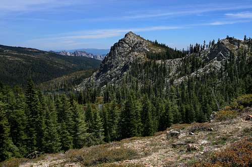
 Boulder Peak above Echo Lake, the largest lake in the Seven Lakes Basin
Providing maximum scenery for minimal effort, trip along the Pacific Crest Trail to the Seven Lakes Basin makes an excellent prelude to an ascent of Boulder Peak. Far-reaching views remain constant throughout the entire trip. While Mt. Shasta is scenery nonpareil, it is complimented by Mt. Eddy, the Trinity Alps, the Russian Wilderness, the Castle Crags, Grey Rocks and the many lakes found in the Trinity Divide. Boulder Peak itself, towering above the Seven Lakes Basin is not the least of these spectacles. After departing the PCT, the route to the summit continues along the rim high above the Seven Lakes, providing an exciting conclusion to the trip to the top. The rocky summit seems untrod by human feet and the sense of vastness and isolation that is a hallmark of the Klamath Mountains is abundant.
Route Description
 Mt. Shasta and "Scott Camp Mountain" from the PCT en route to Boulder Peak
The trail begins at the PCT trailhead on Gumboot Saddle. It begins heading south through a glade composed predominantly of Shasta Red Fir. The route soon climbs out of the trees and views of Mt. Eddy, Gumboot Lake and Mt. Shasta are excellent. The trail is level and traverses the crest of the Trinity Divide. After 0.75 miles the PCT shifts from the western side of the crest, which it has followed up to this point, to the eastern side. Another 0.25 miles later it passes through a saddle and returns to the western side of the crest, where it will remain until the pass leading to the Seven Lakes Basin. As the trail approaches the saddle, it traverses the large, sweeping basin containing the Mumbo Lakes. While the upper lake is shallow, the lower lake is deeper. Views of the Trinity Alps continue to improve, as do views of the Russian Wilderness, further north. To the south, the cluster of high Trinity Alps peaks that are focused around Gibson Peak are visible.
A little over 2.0 miles from the trailhead, the saddle separating the Mumbo Lakes basin with the Seven Lakes Basin is reached. Here Boulder Peak comes into view for the first time. Its’ sharp summit and sheer, rugged cliff rising out of the deep blue waters of Echo Lake are a fine vista to behold. Further to the south, beyond Boulder Peak, the hulking bulk of the Grey Rocks lurk ominously. The Grey Rocks are an impressive group of extremely rugged peaks composed of sedimentary rock. No trails lead to the summit, although they can be reached via a difficult cross-country trip from Tamarack Lake.
 The Castle Crags are visible beyond Boulder Peak and Echo Lake
From the saddle, the PCT swings east, traversing the upper reaches of the ridge that separates the Seven Lakes Basin from the headwaters of the Sacramento River. The ridge eventually leads to the Castle Crags. A low notch in the ridge is reached by an short scramble above the PCT and reveals excellent views of Mt. Eddy and Mt. Shasta, rarely visible in close perspective to one another. A similar, though somewhat less pleasing view can be had from the summit of Boulder Peak. From the point where the PCT heads east toward the Castle Crags, a prominently visible use trail continues south and quickly joins an extremely rugged 4x4 road. This road descends down into the Seven Lakes Basin, providing access to six of the seven lakes. To reach the seventh, Helen Lake, and Boulder Peak, begin climbing up the slope above the road after 0.35 miles, continuing to angle south as one climbs. When the lake is reached, head toward the west side of the lake. Mt. Shasta can be seen peering through the trees to the north. Climb the ridge west of the lake. Once on the summit of the ridge, it is a simple, beautiful cross-country trip to the base of Boulder Peak. The views continue to be excellent and the travel is generally easy. Once one reaches the peak, it is an easy scramble up the south face to the summit.
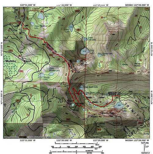
Map
Getting There
 Mt. Eddy and Mt. Shasta seen from the PCT near Boulder Peak
From the town of Mt. Shasta, head west on W. Lake, crossing over I-5. At the stop sign, turn left onto Old Stage Road. After 0.25 miles, veer right onto WA Barr Road. Continue south, crossing over the dam that impounds the Sacramento River and forms Lake Siskiyou. At the intersection with Castle Lake Road, stay straight. The road becomes Forest Road 26. Follow this road for nearly 12 miles. A signed fork indicates Gumboot Lake is 0.5 miles to the left. Continue to the right, climbing up the cirque that contains the Gumboot Lakes. The PCT Gumboot Trailhead is located at the summit with a good parking lot.