
-
 7961 Hits
-
 77.48% Score
-
 8 Votes
|
|
Route |
|---|---|
|
|
41.14053°N / 122.4543°W |
|
|
Hiking, Scrambling |
|
|
Summer, Fall |
|
|
Overview
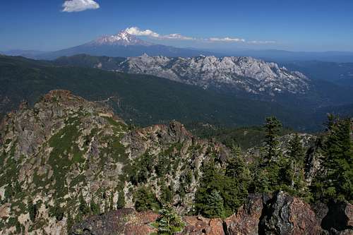
 Mount Shasta from the Grey Rocks
The route up Cerulean Ridge is the most direct route to the summit of Grey Rocks North, the highest point in the Grey Rocks. The route is incredibly scenic, passing by Cerulean Lake and with excellent views nearly the entire route. The greatest difficulty encountered is the extensive brushfields cloaking the southern face of the Grey Rocks. Despite this obstacle, absolutely spectacular views await.
The road leading to the Cerulean Lake route to the summit of the Grey Rocks is seldom used and degrades rapidly about halfway in. Low clearance vehicles are advised to park wherever they no longer feel comfortable proceeding. It is also possible that downed trees may impede progress. Some effort has been made at clearing these but as the road is infrequently used, this may be an issue. Another potential problem on this route is the risk of losing one’s way while in the brush. While the chance of getting lost is small, there is the prospect of finding oneself adrift in a sea of brush. It is also important to be aware of the route one takes, both in scrambling over the rocks and making ones way through the brush on the south side of the Grey Rocks. The way is maze-like and the return trip will be much easier if landmarks are observed.
Route Description
 The ridge leading to the false summit
From the clearing where one parks, the road continues uphill, though it is rocky and in poor condition. Follow the road for 0.25 of a mile. The road will fade out when it intersects the creek flowing out of Cerulean Lake. Depending on what time of year, the creek may have a substantial flow. To head directly to the Grey Rocks rather than going to the lake, angle towards the ridge across the creek and begin to climb. If the intent is to visit the lake first, do not cross the creek, instead follow its banks and surmount a short rocky slope to reach the lakeshore. The edge of the lake is choked with azaleas and other shrubs so it is hard to get down to the water. There is a large rock protruding from the brush from which great views of the lake and the Grey Rocks high above can be had.
To continue towards the summit, follow the ridge above the west side of the lake. As one climbs higher, views of the cirque get better. Peak 7,070 dominates the east side and far below a secondary lakebed becomes apparent. During the spring runoff a small, second lake appears above Cerulean Lake. The ridge leads to what, from this perspective, may seem like the highpoint of the Grey Rocks formation. Unfortunately this is a false summit. The true highpoint can be seen to the left. It is inaccessible from the north due to the sheer cliffs. It is necessary to loop around the south side of the summit and ascend the east side. The best route to take is to aim for the obvious notch just to the right of the false summit. Brush may be an issue in the lower sections of the ridge but there is plenty of rock to scramble on and it is possible to negotiate the whole area without having to bushwhack. There will be plenty of that to come. As one continues to climb, the tree cover on the ridge becomes denser. This is an indication that the false summit is at hand.
 Cerulean Lake
Once the notch has been achieved, the views to the south open up. The massive south summit of the Grey Rocks holds a commanding place in the vista. Tamarack Lake and Red Mountain, the southernmost peak in the Trinity Divide, are obvious a little further south. The Trinity Alps constitute the western horizon. The contrast between the northern and southern sides of the Grey Rocks is startling. On the north side the mountain has a grayish hue, the rock is exposed and rugged and the brush is generally kept to a minimum. The southern side is covered in brush and the rock is dark and weathered.
 The gully leading to the false summit
The most direct route from this point to the summit would be to simply plow through the brush, heading east along the base of the rock ramparts that line the top of the ridge. If an intense bushwhack seems unappetizing, there is an easier route. Climb back onto the north side of the notch and make your way to the base of the false summit. This should only be another 20-30 yards away. There is a rocky gully that leads to the top of the false summit. When climbing the gully, the easiest route is along the right side. Once on top of the false summit, the views are excellent, particularly of Mount Shasta, nearly 25 miles distant. Continue east, towards the summit, now climbing down the east side of the false summit. Here one reaches a saddle between the highpoint and the false summit. It may be possible to climb directly up to the top, but the exposure, quality of the rock, and sheer walls discourage the attempt. The easiest way to climb the Grey Rocks highpoint is from the east. The challenge is getting to the east side. At this point, one must be prepared for some bushwhacking.
 The route through the brushfield
Below the saddle, a brush filled gully leads down into the basin between the north and south summits of the Grey Rocks. On the far side of the gully there is a brush-free vein of scree that leads along the base of the cliffs below the highpoint. Cross the saddle to the east side of the gully and descend on the scree. This will ultimately lead to a large cluster of boulders at the bottom of the gully. The route east, at the base of the cliffs, is obvious. Once on the east side, there is a clear route to the top. However, the brush encroaches right up to the base of the cliffs. It is possible to cover a good deal of the distance by scrambling on boulders that form small islands in the brush but at some points it is simply necessary to push through the oppressive shrubs.
 Looking up the gully leading to the summit
The push through the brush field lasts for 0.2 of a mile. There are some small ravines penetrating the cliffs but disregard them and continue east maintaining a level course. On the southeast side of the north summit, as one nears the saddle separating the north summit from the south summit, an obvious gully leads to the north. Ascend the gully, staying on the rock as much as possible. It is feasible to make it all the way to the top without passing through too much of the brush. Once on top, views open up in all directions. To the south, the southern summit of the Grey Rocks towers high above its glacially carved canyon. Tamarack and Twin Lakes are visible and Red Mountain marks the southern end of the Trinity Divide. To the west is an arresting view of Bonanza King and the Trinity Alps. To the east are Grey Rock Lake, Lassen Peak, Crater Peak, Burney Mountain, as well as Tombstone Mountain and High Mountain. To the north, Cerulean Lake is nestled in the basin far below. Mount Shasta presides majestically over the region, high above the rugged Castle Crags, which seem to spread out at your feet.
 Mount Shasta and the Castle Crags from the summit
To return, retrace the route back to the Cerulean Lake. As one descends the gully from the summit, a recommended side trip is to the saddle separating the northern and southern summits. The view of the canyon below the south summit is not to be missed. The careful observer can make out tiny Whalan Lake, cradled in its stark, rocky bowl, as well as a small part of Mears Lake, another 400 feet lower.
Maps
 The Cerulean Ridge Scramble