
-
 12305 Hits
-
 83.69% Score
-
 17 Votes
|
|
Area/Range |
|---|---|
|
|
46.50170°N / 8.49998°E |
|
|
Hiking, Mountaineering, Trad Climbing, Sport Climbing, Scrambling, Skiing |
|
|
Spring, Summer, Fall, Winter |
|
|
10472 ft / 3192 m |
|
|
... waiting for suggestions / proposals / requests and, of course, waiting for someone who wants to share the maintainance of the page with me ...
In this valley you can
- Hike : many summits, especially the ones of the S border, are not difficult along the normal routes, the only ones that are worth to be done
- Climb (when I say climb I mean Rock-Climb) : the range from Poncione di Maniò to Poncione di Ruino host some very fine classic rock routes and many difficult sport routes
- do Alpinistic activity : from Pizzo Gallina toward East (till Pizzo Pesciora) the normal routes to the main summits are the typical old fashion
- do some Ski-Mountaneering trips, not so many but very fine on both the sides of the valley
- spend relaxing hours ... on the fine wide grass slopes on both sides of the valley, just with a little walk from the Nufenenpass road
begins at Airolo and ends at the Nufenenpass (Passo della Novena), border to Wallis
4 main built up areas in the valley : from East (ascending the valley)
- Bedretto (3 small settlements : Fontana - Villa - Bedretto
- Ossasco - starting point for the Capanna Cristallina
- Ronco
- All'Acqua - starting point for the Capanna Piansecco
Accesses
Accessing is really easy :
- from Bellinzona (Italy or Eastern switzerland through the san Bernardino tunnel) straight along the highway of Gotthard tunnel ...
once near it follow the signs for Airolo or Nufenen the road is open all year long only up to All'Acqua) last built up area of the valley
- from Zurich (Germany or Northern Switzerland) along the highway of Gotthard tunnel till Airolo, exit and follow as previous
- from Wallis (France or Western Switzerland) along the Rhone valley up to Ulrichen (1346m) and follow signs for Nufenen pass, crossing it and descending. the Nufenenpass is not open all year long (normally closed from November to May)
There are 3 good mountain refuges :
the Cristallina (recently rebuilt after an avalanche caused the distruction of the old one)
- good for the hikes in the valleys and on the summits of the S ridge
- a must here is the Ski-mountaneering to the Cristallina followed by the cross of Bocchetta di Valleggia and Bocchetta di Val Piana to gain the Val Cavagnolo and make a wonderful skirun down to All'Acqua
the Piansecco (recently enhanced and enlarged due to the big numbers of people coming here)
- good (not essential) for the Ski-mountaneering to Poncione di Maniò and Pesciora
- the other summits, if climbed along the normal route, and the sport routes to Poncione di Cascina Baggio and Poncione di Ruino, don't require a night stop at the refuge
the Gries in the Val Corno, the left (western) part of the higher valley. Fine hiking refuge, normally used by tourists who want to have dinner in a fine scenery ...
Passo della Novena 2480
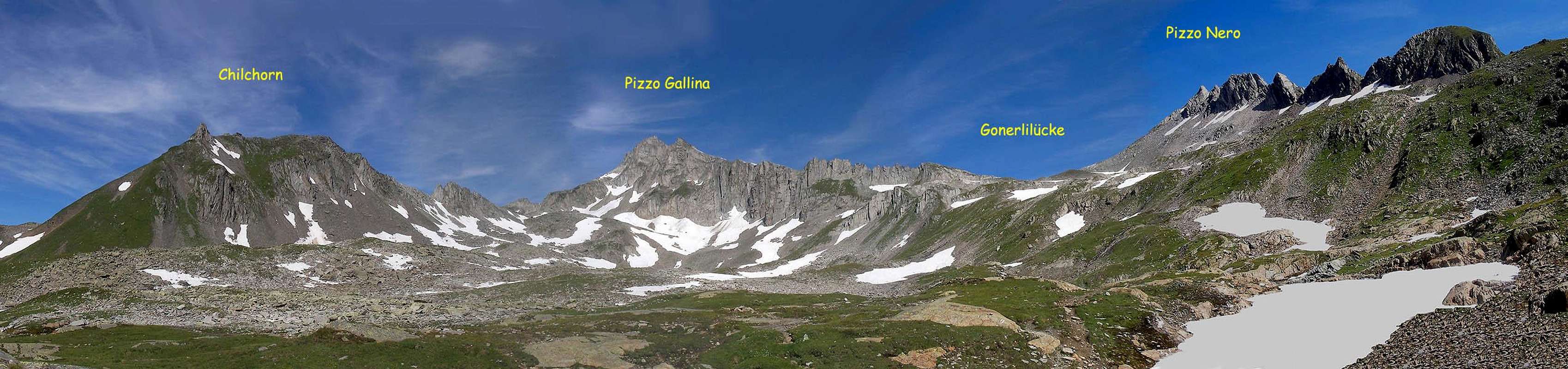
Chilchorn 2789 - Pizzo Gallina 3061 - Gonerlilücke 274 - Pizzo Nero 2904
![]()
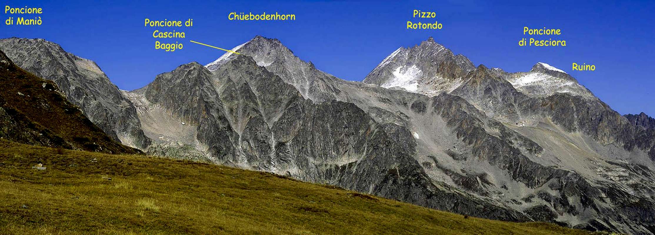
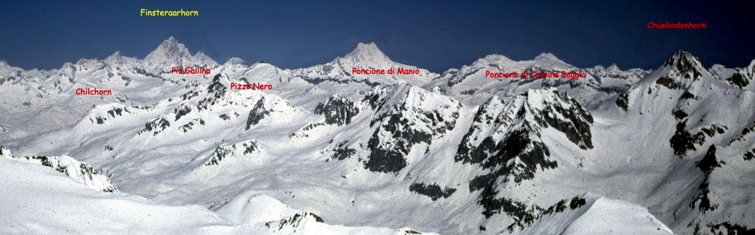
Sidelenlücke 2744 - Forcella 2845 - Westlicher Gerenpass 2695 - Poncione di Maniò 2924 - Passo di Maniò 2596 - Poncione di Cassina Baggio 2860 - Gerenpass 2683 - Chüebodenhorn 3070 - Passo di Rotondo 2754 - Pizzo Rotondo 3192 - Poncione di Ruino 2965 - Passo inferiore di Pesciora - Gerenhorn 3076 - Passo superiore di Pesciora - Poncione di Pesciora 3120
![]()
Passo dei Sabbioni 2993 - Witenwasserenstock 3025 - Hüenerstock 2889 - Ronggergrat 2695 - Passo di Cavanna 2613
Pizzo Lucendro 2962 - Passo di Lucendro 2532 - Pizzo della Valletta 2726 - La Fibbia 2738 - Passo del San Gottardo 2108
--- AIROLO --- 1125
Passo della Novena (2480m)
![]()
Nufenenstock 2886 - Griespass 2485 - Grieshorn 2930 - Punta di Elgio 2837
Passo San Giacomo 2213 - Pizzo San Giacomo 2924 - * Pizzo Grandinagia 2774 - Passo Grandinagia 2698
Pizzo Cavagnolo 2836 - Poncione Val Piana 2660 - Poncione Cavagnolo 2821 - Poncione di Valleggia 2873 - Cima di Lago 2833 - Passo di Cristallina 2568 - Cristallina 2912
--- val Torta
Passo del Naret 2438 - Il Madone 2756 - Poncione del Vespero 2717 -
--- AIROLO --- 1125
this means that the avalanche danger is very high also due to the fact that this is the typical V valley, eroded by a river (the Ticino of course) and the safe points are very rare.
So in winter, after a snowfall, you'd better stop at the skiarea of Airolo.
Poncione di Cascina Baggio - 2814m - SSE ridge : 400m - IV
Poncione di Cascina Baggio - 2986m - SE ridge : 250m - III
Poncione di Cascina Baggio - 2860m - E spur : 350m - IV+
Poncione di Cascina Baggio - Piccadilly di Bedretto - 400m - VI
Poncione di Cascina Baggio - Tanti Auguri - 400m - VI
Poncione di Ruino - 2669m - W spur - 200m - IV+
Poncione di Ruino - 2669m - S wall - 250m - V. A1
classic mountaneering routes difficulties French scale
Pizzo Gallina - 3061m - F/PD
Pizzo Nero - 2904m - F
Chüebodenhorn - 3070m - F
Pizzo Rotondo - 3192m - PD
classic ski-mountaneering routes
![]()
Poncione di Maniò - 2924m - BSA
Poncione di Pesciora - 3120m - BSA
Cristallina - 2912m - MS
Hikes
just give a glance all around ... summits normally require a good skill : for experienced hikers
I can suggest 2 really fine hikes pointing to 2 small lakes of the N side of the valley :
- from Capanna Piansecco to Gerenpass ... the panorama is breathtaking
- from Capanna Piansecco to Nufenenpass passing the Laghetto delle Pigne
Overview
| Ticino ... a river and a well known region of Switzerland ... well known ? most think that the Ticino (canton) ends at the Gottardo (Gotthard) pass ... nothing more wrong ! the finest range of the whole canton is just the one West of Gottardo pass : the Val Bedretto. |  |  |
In this valley you can
- Hike : many summits, especially the ones of the S border, are not difficult along the normal routes, the only ones that are worth to be done
- Climb (when I say climb I mean Rock-Climb) : the range from Poncione di Maniò to Poncione di Ruino host some very fine classic rock routes and many difficult sport routes
- do Alpinistic activity : from Pizzo Gallina toward East (till Pizzo Pesciora) the normal routes to the main summits are the typical old fashion
- do some Ski-Mountaneering trips, not so many but very fine on both the sides of the valley
- spend relaxing hours ... on the fine wide grass slopes on both sides of the valley, just with a little walk from the Nufenenpass road
Getting There
Val Bedretto is the Easternmost side of the High Ticino valley (Val Leventina)begins at Airolo and ends at the Nufenenpass (Passo della Novena), border to Wallis
4 main built up areas in the valley : from East (ascending the valley)
- Bedretto (3 small settlements : Fontana - Villa - Bedretto
- Ossasco - starting point for the Capanna Cristallina
- Ronco
- All'Acqua - starting point for the Capanna Piansecco
Accesses
Accessing is really easy :
- from Bellinzona (Italy or Eastern switzerland through the san Bernardino tunnel) straight along the highway of Gotthard tunnel ...
once near it follow the signs for Airolo or Nufenen the road is open all year long only up to All'Acqua) last built up area of the valley
- from Zurich (Germany or Northern Switzerland) along the highway of Gotthard tunnel till Airolo, exit and follow as previous
- from Wallis (France or Western Switzerland) along the Rhone valley up to Ulrichen (1346m) and follow signs for Nufenen pass, crossing it and descending. the Nufenenpass is not open all year long (normally closed from November to May)
accomodations
And all can be done in one day starting from all the towns between Milano and Zurich : the Gottardo Highway + Tunnel and the good road, open from end of May to end of October, allow to get the 2400+ m of Nufenen Pass very quickly.There are 3 good mountain refuges :
the Cristallina (recently rebuilt after an avalanche caused the distruction of the old one)
- good for the hikes in the valleys and on the summits of the S ridge
- a must here is the Ski-mountaneering to the Cristallina followed by the cross of Bocchetta di Valleggia and Bocchetta di Val Piana to gain the Val Cavagnolo and make a wonderful skirun down to All'Acqua
the Piansecco (recently enhanced and enlarged due to the big numbers of people coming here)
- good (not essential) for the Ski-mountaneering to Poncione di Maniò and Pesciora
- the other summits, if climbed along the normal route, and the sport routes to Poncione di Cascina Baggio and Poncione di Ruino, don't require a night stop at the refuge
the Gries in the Val Corno, the left (western) part of the higher valley. Fine hiking refuge, normally used by tourists who want to have dinner in a fine scenery ...
the Northern ridge
(from W to E)Passo della Novena 2480
Chilchorn 2789 - Pizzo Gallina 3061 - Gonerlilücke 274 - Pizzo Nero 2904
Sidelenlücke 2744 - Forcella 2845 - Westlicher Gerenpass 2695 - Poncione di Maniò 2924 - Passo di Maniò 2596 - Poncione di Cassina Baggio 2860 - Gerenpass 2683 - Chüebodenhorn 3070 - Passo di Rotondo 2754 - Pizzo Rotondo 3192 - Poncione di Ruino 2965 - Passo inferiore di Pesciora - Gerenhorn 3076 - Passo superiore di Pesciora - Poncione di Pesciora 3120
Passo dei Sabbioni 2993 - Witenwasserenstock 3025 - Hüenerstock 2889 - Ronggergrat 2695 - Passo di Cavanna 2613
Pizzo Lucendro 2962 - Passo di Lucendro 2532 - Pizzo della Valletta 2726 - La Fibbia 2738 - Passo del San Gottardo 2108
--- AIROLO --- 1125
the Southern ridge
(from W to E)Passo della Novena (2480m)
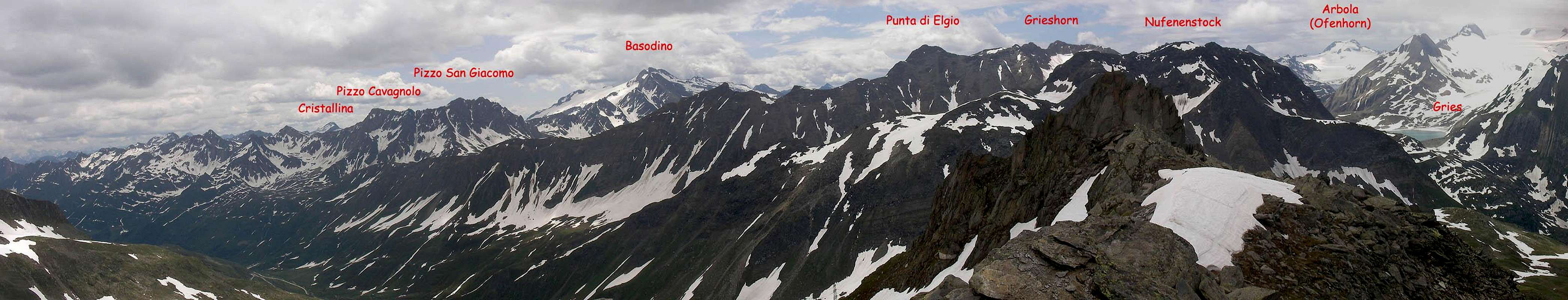
Nufenenstock 2886 - Griespass 2485 - Grieshorn 2930 - Punta di Elgio 2837
Passo San Giacomo 2213 - Pizzo San Giacomo 2924 - * Pizzo Grandinagia 2774 - Passo Grandinagia 2698
Pizzo Cavagnolo 2836 - Poncione Val Piana 2660 - Poncione Cavagnolo 2821 - Poncione di Valleggia 2873 - Cima di Lago 2833 - Passo di Cristallina 2568 - Cristallina 2912
--- val Torta
Passo del Naret 2438 - Il Madone 2756 - Poncione del Vespero 2717 -
--- AIROLO --- 1125
Some warnings ...
this fabulous valley is one of the most snowy of the whole alpine range : you may happen to arrive, in winter, to All'Acqua along a road digged into snow walls high up to 5-6 meters ...this means that the avalanche danger is very high also due to the fact that this is the typical V valley, eroded by a river (the Ticino of course) and the safe points are very rare.
So in winter, after a snowfall, you'd better stop at the skiarea of Airolo.
Recommended routes ecc.
classic rock routes - low & moderate difficulties UIAAPoncione di Cascina Baggio - 2814m - SSE ridge : 400m - IV
Poncione di Cascina Baggio - 2986m - SE ridge : 250m - III
Poncione di Cascina Baggio - 2860m - E spur : 350m - IV+
Poncione di Cascina Baggio - Piccadilly di Bedretto - 400m - VI
Poncione di Cascina Baggio - Tanti Auguri - 400m - VI
Poncione di Ruino - 2669m - W spur - 200m - IV+
Poncione di Ruino - 2669m - S wall - 250m - V. A1
classic mountaneering routes difficulties French scale
Pizzo Gallina - 3061m - F/PD
Pizzo Nero - 2904m - F
Chüebodenhorn - 3070m - F
Pizzo Rotondo - 3192m - PD
classic ski-mountaneering routes
Poncione di Maniò - 2924m - BSA
Poncione di Pesciora - 3120m - BSA
Cristallina - 2912m - MS
Hikes
just give a glance all around ... summits normally require a good skill : for experienced hikers
I can suggest 2 really fine hikes pointing to 2 small lakes of the N side of the valley :
- from Capanna Piansecco to Gerenpass ... the panorama is breathtaking
- from Capanna Piansecco to Nufenenpass passing the Laghetto delle Pigne