
-
 14244 Hits
-
 84.82% Score
-
 19 Votes
|
|
Mountain/Rock |
|---|---|
|
|
28.72960°N / 17.8351°W |
|
|
Hiking |
|
|
Spring, Summer, Fall, Winter |
|
|
7322 ft / 2232 m |
|
|
Overview
 Pico de la Nieve Pico de la Nieve |
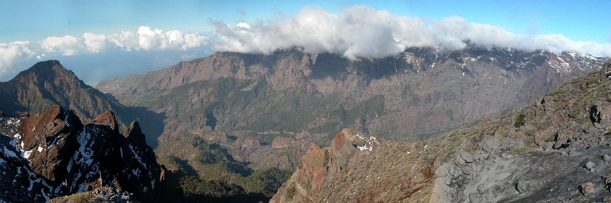
Pico de la Nieve, the Snow Peak among La Palma's mountains, is part of the Caldera de Taburiente, the world's largest erosion crater. Like its namesake on neighbouring Gran Canaria it is located on the rim of a large Caldera but here the likeness already stops. The Palmerian Pico de la Nieve is 400m higher than its counterpart and is actually covered with snow for several days and weeks each year. Moreover, it is part of a natural park, the Parque Nacional de la Caldera de Taburiente and is clear of any construction. The Gran Canarian summit on the other hand is marred by multiple radio, TV and radar installations.
Pico de la Nieve is among the highest summits of La Palma. Like the other caldera rim summits it towers 1500m above the crater with near vertical walls to the inside and a smooth 30° slope on the outside. The main route to the summit is the Ruta de la Cresteria, a two day trekking trail, which follows two thirds of the caldera crest. On the other hand Pico de la Nieve is one of the few caldera summits which can be reached from the outside. There is a long 2000m ascent from the town of Las Nieves which can be cut short by driving up the Palmeran mountain road LP-22. This leads to a parking lot roughly 300m below the summit.
Consequently Pico de la Nieve is one of the most popular summits of La Palma, only surpassed by Roque de los Muchachos and Pico de la Cruz, which both can be reached by car (the parking lots are very close to these summits). On a fine day you'll meet all kinds of people on the summit.
Pico de la Nieve is part of a triple peak of which it is the lowest one. To the north you can find an unnamed peak (2238m) and the lower of the two Pico de la Cruz (2252m). All three are interconnected by a ridge with a pass, Degollada de Barranco Seco (1988m) between P2252 and Pico de la Cruz. From the summits of all three peaks you have perfect views into the caldera across a beautiful set of bizarre erosion towers. In particular the view into the very narrow gorges which start into the caldera between the three summits is breathtaking.
|


Summit Panorama
  |
Getting There
 La Palma, like all the other Canarian Islands can easily be reached from almost all major European airports. The airport is rather small and compared to Tenerife or Gran Canaria air trafic is rather low. There are almost no regular flights but all year round you'll be able to book charter flights. The airport itself is located on the eastern coast of the island, almost at its centre. La Palma, like all the other Canarian Islands can easily be reached from almost all major European airports. The airport is rather small and compared to Tenerife or Gran Canaria air trafic is rather low. There are almost no regular flights but all year round you'll be able to book charter flights. The airport itself is located on the eastern coast of the island, almost at its centre.There are two trailheads, one near the mountain road LP-22 (a small parking lot) one at the Ermita de la Virgen del Pino right in the centre of the island. The ascent from the Ermita is a long affair. Be sure how to return if you are not trekking the whole Ruta de la Cresteria. Usually either Pico de la Nieve or Pico de la Cruz (the large one to the north-east of the caldera) are used for overnight "accommodation" while trekking Ruta de la Cresteria. Accommodation here means sleeping under the open sky. Thus you can imagine how long the hike from the Ermita actually takes.
|
|


Red Tape
The summit of Pico de la Nieve is part of the Parque Nacional de la Caldera de Taburiente. This means that you are not allowed to leave the trails or to camp in the vicinity of the summit. In summer you can sleep under the open sky, however, but this is bound to be very cold at every time of the year. Depending on the weather leaving the trails can be rather dangerous. The caldera is composed of rather loose rocks and in wet or stormy conditions many a rockfall will occur.When To Climb
Pico de la Nieve can be climbed all year. Sometimes (e.g. in Feb 2005) the road to the caldera rim is closed due to snow. In that case it is not advisable to do the hike to the summit. Why? The clouds which love to hver around the caldera summits are very wet. In snowy conditions often ice layers are deposited on top of the snow. Even moderate slopes of 30° get dangerous without the proper equipment. And who would bring crampons to La Palma?Camping and Other Accommodation
Camping is a bit of a problem on La Palma. There are some official campgrounds in the north but the one near Los Canarios is still a project. There are, however, a couple of "Zonas Recreativas" where sometimes you are allowed to pitch a tent. On the caldera crest there are no such places, only near Punta de los Roques (south of Pico de la Nieve) you can find a cabin (called rifugio). Most trekkers on Ruta de la Cresteria use the cabin or the space around it to sleep below the open sky.Other accommodations are no problem. Every European travel office will be able to book hotels, rooms and apartments for you. I won't include any links here because all of them definitely are commercial. Another option is to rent a finca (rural house) from the owners directly. You'll have to google for these but sometimes prices are low enough for the scheme to be worthwhile.
Weather Conditions On La Palma
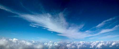 Above the trade wind clouds
I'm a bit at a loss here. Usually all year round the Canarias have the same weather with litlle alterations: north-eastern trade winds which deposit fog and dew on the north-eastern slopes of the islands. The eastern and southern parts usually are very dry and there you'll get some hours of sunshine each day. Especially on the higher islands like La Palma you usually don't have to worry about weather too much. The mountaintops will stick out of the clouds.
Now here's my problem: when we were on our vacation to La Palma in late Febuary 2005 we had a week of fierce western winds which were loaded with moisture. We had veritable downpours for hours on end and several times couldn't even drive by car because the roads were flooded. I'm quite sure that this was a freak phenomenon. The western side of La Palma usually gets 28cm (19 inches) of rain per year!
There are no reliable weather forecasts for the mountain regions of La Palma. Often a cloudless day turns into a foggy one within half an hour. Especially the Cumbre Vieja Range is prone to these fogs and here orientation among the lava and scree fields gets very difficult. This is the main reason why you should never leave the trails there.
Forecasts for the coastal regions, however are available. You have to subtract 1°C for every 100m of altitude so that Roque de los Muchachos will still be near freezing when the coasts have already fine and sunny beach weather. The following table gives a little overview about the average weather data of the capital of Santa Cruz:
| Month | Jan | Feb | Mar | Apr | May | Jun | Jul | Aug | Sep | Oct | Nov | Dec |
| Avg. day temp.[°C / °F] | 21 / 70 | 21 / 70 | 22 / 72 | 22 / 72 | 22 / 72 | 24 / 75 | 25 / 77 | 26 / 79 | 26 / 79 | 26 / 79 | 24 / 75 | 22 / 72 |
| Avg. night temp.[°C / °F] | 15 / 59 | 14 / 57 | 15 / 59 | 16 / 61 | 17 / 63 | 18 / 64 | 19 / 66 | 21 / 70 | 21 / 70 | 19 / 66 | 18 / 64 | 16 / 61 |
| Water temp.[°C / °F] | 19 / 66 | 18 / 64 | 19 / 66 | 19 / 66 | 19 / 66 | 20 / 68 | 22 / 72 | 23 / 73 | 22 / 72 | 22 / 72 | 21 / 70 | 20 / 68 |
| Sunny Hours / Day | 5 | 6 | 6 | 7 | 8 | 9 | 10 | 9 | 8 | 6 | 5 | 5 |
Maps 'n' Books
Please excuse me if I only post German maps and books. I know there are editions in all European languages but I'm not aware of them. Any help is very welcome!I have used a fantastic map by Freytag & Berndt which shows all of the many hiking and biking trails of the island. With its scale of 1:30000 it is still large enough to be usefu for car tours as well. Moreover here you will find all the new designations and acronyms (which were changed some few years back).
- La Palma
1:30000
Edition Freytag & Berndt
ISBN: 3-7079-0346-X
The guidebook I used is every bit as good as the map with excellent tour descriptions. It is available in English as well but I am not sure about the quality of the translation.
- La Palma
A. and W. Wolfsperger
Rother Verlag
ISBN:
3-7633-4246-X (German)
3-7633-4808-5 (English)