
-
 6712 Hits
-
 83.1% Score
-
 16 Votes
|
|
Mountain/Rock |
|---|---|
|
|
49.16526°N / 7.82398°E |
|
|
Sport Climbing, Toprope, Bouldering, Scrambling |
|
|
Spring, Summer, Fall |
|
|
978 ft / 298 m |
|
|
Overview
 Rappenwand east face Rappenwand east face |
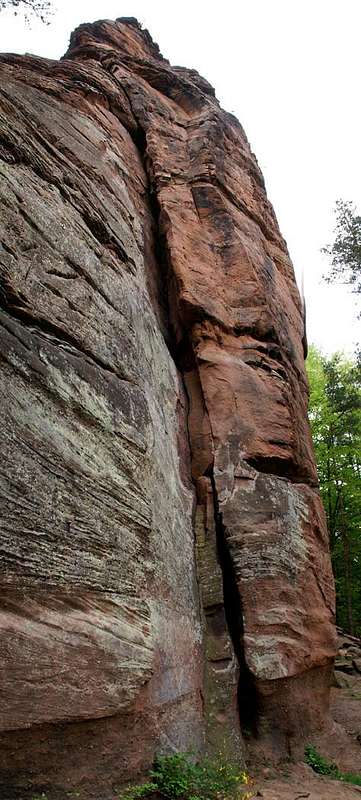
The little village of Erfweiler is located deep in the Südpfalz / Wasgau Climbing Region, so deep that it is kind of a dead end village. Though two roads lead to it both start from different parts of the town of Dahn and only touch Erfweiler in its easternmost part. The bulk of the villageleads from the intersection of the two roads to the north-east, leading directly into one of the finest valleys, Glastal. Among climbers Glastal has earned its renown for two very fine crags which oppose each other across the valley. Glasfelsen is the one of the, Erfweiler Rappenwand the other.
When speaking about Rappenwand or Rappenfels one always should add the location. On my count there are five cliffs of this name in the Südpfalz region - and I only counted the ones with climbing routes on them. The Rappenwand I'm discussing on this page is a massivechunk of vertical sandstone rock, which rises out of the neighbouring hills, like so many of the other cliffs in the region. It can be easily (2) climbed by scrambling up one of its sides and coming to it from the back. You need to step over - or rather jump a deep chasm and then finalise the ascent by some exposed climbing to the summit plateau.
But apart from that easy route there are the sports climbing ones - ranging in difficulty from 3 up to 10!, pillars and overhangs, lofty traverses and a nice off-width crack make Rappenwand one of the most popular crags of the area. And like everywhere in Wasgau you have to deal with vegetation high up in the wall. Its height is about 70m and most climbs will need three pitches.
On top of Rappenwand there are two further objects, waiting to be climbed: Fenstertürmchen, a towerlet which is broken through by three rock windows and Nordgrattürmchen, another smaller tower which has some one pitch routes for beginners (?). Both are very exposed on their eastern sides, which hover above Glastal valley. Fenstertürmchen has some interesting bouldering problems but the scariest "climb" is the jump from the Rappenwand main summit across the deep chasm down onto it. I stood there contemplating it but got too weak in the knees to try.
All routes onto Rappenwand are well (but sparingly) equipped with protecting bolts and rings. Some run across honeycomb structures - erosion forms which are typical for the Wasgau sandstone rocks and which demand a special jamming technique to cross them.
As you can see in the Red Tape section - often access to some of the climbing cliffs is restricted because of breeding peregrine falcons. In recent years a couple nested on Rappenwand - you can still see the place in the east face (go for the droppings) but this year (2006) the cliff is free while neighbouring Glasfelsen is closed. Peregrines seem to be very shy birds, even taking off from their roost when people hike along beneath the base of the crag. I have been "chased" from three cliffs the last week alone by Peregrines which is a very good sign since the species was on the brink of extinction in our country.
 |
 |
 |
 |
 |
Climbing Routes to Rappenwand and its Satellites
 Climber on the upper part of the east face of Rappenwand
Rappenwand has a number of routes of all difficulties. Together with its satellites, Fenstertürmchen and Nordgrattürmchen, and its less popular neighbour Westlicher Rappenfels it offers everything from scrambling to bouldering to sports climbing.
Rather than reprinting the copyrighted information from the site of the Vereinigung Pfälzer Kletterer I link to their routes database directly with some summary info. Here is the link to the complete database.
| Feature | Routes link | Summary |
| Rappenwand | Rappenwand | 17 routes with variations ranging from 2 - 10- |
| Rappenwand, Fenstertürmchen | Fenstertürmchen | 7 routes ranging 3+ - 7 |
| Rappenwand, Nordgrattürmchen | Nordgrattürmchen | 4 routes with variations ranging from 1 - 5+ |
| Westlicher Rappenfels | Westlicher Rappenfels | 8 routes with variations ranging from 3 - 6+ |
 |
 |
 |
 |
 |
Getting There
 South-east pillar
Rappenwand is located north of Erfweiler, a 10 minute hike from the last parking lot at the end of the village. Erfweiler itself is hidden very deep inside Pfälzerwald and thus the itineraries are a bit longish. The closest airports are at Frankfurt and Stuttgart so the itineraries start there too.
From Frankfurt
There are two possible routes which both take equally long- Via Ludwigshafen
- From Frankfurt take motorway A5 southward to Darmstadt.
- There change to A67 south.
- At Viernheimer Dreieck turn onto A6 west. Leav
- e it at Frankenthaler Kreuz for A61 south.
- At Mutterstädter Kreuz take A65 south until you reach Landau.
- At Landau turn on B10 west.
- At Hinterweidental turn onto B427 south which will take you to Dahn.
- In Dahn, after you have driven around Jungfernsprung there is an intersection directly in the town centre. Turn off left onto K39 which takes you to Erfweiler.
- In Erfweiler don't follow the main road (K39) where it bends right but rather go straight on (but later keep to the right) until the road ends in a parking lot
- From the parking lot follow the left hand trail, signed "Glastal" which takes you to the base of the cliff.
- Via Kaiserslautern
- From Frankfurt take motorway A3 west
- At Mönchhofdreieck turn onto A67 south
- At Rüsselsheimer Dreieck take A60 west
- At Kreuz Mainz Süd take A63 south
- At Kreuz Kaiserslautern turn onto A6 west
- At Kreuz Landstuhl turn onto A62 south
- At Pirmasens turn onto B10 east
- At Hinterweidental take B427 south to Dahn
- In Dahn turn onto K39 to Erfweiler
- In Erfweiler go straight on to the parking lot at the end of the village
From Stuttgart
- Take motorway A8 to Karlsruhe
- At Karlsruher Dreieck turn north onto A5
- Tke the next exit to head for A65
- At Kandel you can leave onto B427 which will lead you directly to Dahn where you can turn right onto K39 to Erfweiler. However the detour to Landau and B10 (see above) will take less time as the roads are better (three or four lanes)
Red Tape
 The big curved overhang
The use of magnesia is not allowed in the whole Südpfalz region. This is rather a directive or an arrangement than an outright law. Thus you probably will get away with using it but do so only when absolutely necessary. Magnesia closes the pores which you find in the sandstone and together they form a smooth surface which will get very slippery in wet conditions. The rule of thumb is to use magnesia in the highest difficulty sections and only extremely sparingly.
A list of guidelines can be found here (in German).
Accommodation
You can find hotels and apartments in Erfweiler and in neighbouring Dahn. Have a look at the following links:There are two campgrounds, one in Dahn at Neudahner Weiher one in nearby Bruchweiler-Bärenbach.
Weather Conditions
The closest available weather information is the one for Pirmasens (20km to the north-west):Pirmasens weather
Maps & Books
Maps
As for maps there is a good overview map (1:50000) by Kompass Verlag but the best ones are the official topographic maps by the state government of Rheinland Pfalz, scaled 1:50000, 1:25000 and 1:5000. All official maps can be found on the web page of Landesvermessungsamt Rheinland Pfalz
1:50000
- Naturpark Pfälzer Wald
Kompass Map WK766
ISBN: 3-85491-523-3
- Pirmasens Süd
LVA RLP Map L6910
ISBN: 3-89637-193-2
1:25000
Books
Here are a number of climbing guidebooks on the region of Südpfalz. The best ones, however, have been published privately and are sold only in selected bookshops of the region.
- Hiking
- Pfälzerwald
B. & J.-Th. Titz
Rother Verlag
ISBN: 3-7633-4268-0 - Klettern im Buntsandstein
U. Daigger, H.-J. Cron
Published privately and out of print
- Pfalz ++, Klettern im Buntsandstein
R. Burkard, P. Weinrich
Published privately
- Klettern im Naturpark Pfälzerwald
Naturfreunde Lambrecht
Published privately - Pfalz & Nordvogesen en bloc
A. Wenner, Y. Corby, I. Bald
Panico Verlag
ISBN: 3-936740-19-4
Climbing