
|
|
Mountain/Rock |
|---|---|
|
|
46.61390°N / 12.83452°E |
|
|
Hiking, Mountaineering, Sport Climbing |
|
|
Spring, Summer, Fall, Winter |
|
|
8104 ft / 2470 m |
|
|
Overview
 From lago di Volaia/Wolayersee
 From Casera Bordaglia di sotto
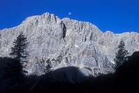 From Obere Wolayer Alpe
Monte Volaia/ Wolayer Kopf belongs to the Carnic Alps main ridge ( west ) and is part of a subgroup called Monti di Volaia/Biegenbirge. This group is composed by 6 main peaks: Biegenkopf ( 2364 m ), Monte Volaia/ Wolayer kopf ( 2470 m ), Sasso Nero ( 2468 m ), Cresta di Chianaletta ( main tower 2472 m ), Monte Canale ( 2540 m ) and Monte Capolago/ Seekopf ( 2554 m ). The word Volaia means airy, breezy, exposed and if you take a look at the steep walls of these mountains you can easily understand why the got this name. The german name Biegengebirge means bended and it's probably related to their geological formation ( Devonian age, 300 million years ) that make them look like an amphytheatre.
This mountain played an important role in the tactics of the First World War in this part of the Carnic Alps because it dominates two important passes like Passo Giramondo and Passo Volaia: all along its summit you can find rests of that sad period like trenches, caves, military emplacements... The normal route it's actually a beautiful warpath built by italian soldiers in 1915. In this area the fightings were not fiercy
like in other places like Pal Piccolo or Jof di Miezegnot but a large amount of soldiers lost their lives for the avalanches and for the extreme conditions of the weather in the winter season.
 From Tacca del Sasso Nero
 The 360° panorama from the top of Monte Volaia is absolutely amazing and when the sky is perfectly clear you can admire countless different mountains: you can see the whole main ridge of the Carnic Alps with fantastic views to the massive Peralba-Avanza-Cjadenis group and to the vertical north faces of Capolago/Seekopf, Coglians ( Hohe warte )and Creta delle Chianevate/ Kellerspitzen; The austrian glaciers dominated by the Grossglockner; the dolomitic groups of the Lienz Dolomites, Dolomiti di Sesto, Dolomiti d'Ampezzo and Dolomiti Pesarine and also the green valleys of the Carnic Prealps.
First known ascent: G. Baldermann with H. Wodl and G.B. Schmid, june 28, 1898.
Summit Views
 Coglians group Coglians group |
 Peralba-Avanza-Chiadenis group Peralba-Avanza-Chiadenis group |
 Gamskofel Gamskofel |
 Lastroni-Rinaldo group Lastroni-Rinaldo group |
 Carnic PreAlps Carnic PreAlps |
 Lienz Dolomites Lienz Dolomites |
Getting there

FROM WEST: From the Brennero motorway take the Bressanone/Brixten exit and then head towards Val Pusteria-Passo Monte Croce Comelico-Sappada-Forni Avoltri-Collina
From Cortina d'Ampezzo to Sappada-Forni Avoltri-Collina
FROM NORTH: From Tarvisio leave the A23 motorway ( Carnia exit ) and then head towards Tolmezzo-Forni Avoltri-Collina
From Passo Pramollo or Passo di Monte Croce Carnico normal road to Tolmezzo-Forni Avoltri-Collina
FROM SOUTH: From Udine normal road to Tolmezzo-Forni Avoltri-Collina
Routes overview
1) Normal route: From Collina reach Baita Edelweiss and take the marked path n°176 towards Forcella Ombladèt. Then turn right and take the warpath to Tacca del Sasso Nero and then the top of Monte Volaia. Easy hike until Tacca del Sasso Nero then a few exposed passages ( UIAA I ) until the top of the mountain. Same path to go back to Collina. 6/7 hours.2) Route from Passo Giramondo: from Pierabec ( Forni Avoltri ) take the marked path n°141/142 to Casera Bordaglia, lake of Bordaglia and Passo Giramondo. Then take the path to Biegenkopf ( not marked ) and monte Volaia. Beautiful easy alpinistic route ( UIAA II ). For the descent use the normal route to Forcella Ombladèt and then take the marked path 141 to Pierabec. 7/8 hours.
3) Diretta ( Via Pichl-Niesser ): From the east ridge 400m of max UIAA IV. Interesting climb but the rock is not always good.
4) From the west face: Not interesting climb, 550 m of UIAA I/II.
There was also an austrian ferrata but they closed it several years ago for a big landslide and I don't think they are going to re-open it. The ferrata was made following a climbing route not technically difficult ( II/III ) but very dangerous for the bad quality of the rock.
Accomodation
Hotel Volaia - CollinaRifugio Tolazzi
Rifugio Lambertenghi-Romanin
E.Pichl hutte
Maps and Books
KOMPASS: Galitar Alpen/ Karnische Alpen1:50000
Kompass map wk60
Kompass verlag
TABACCO: 001 Sappada-Forni Avoltri
009 Alpi Carniche/ Carnia Centrale
BOOKS:
A. de Rovere - M. Di Gallo
Alpi Carniche vol I - Guida ai monti d'Italia
Ed. CAI-TCI 1988