
-
 12935 Hits
-
 74.72% Score
-
 5 Votes
|
|
Canyon |
|---|---|
|
|
Hiking |
|
|
Spring, Summer, Fall, Winter |
|
|
Overview: Beautiful Quick Get-Away
NOTE:This beautiful little canyon was ravished by the August-September 2009 "Station" fire. At the present time, and until further notice, the Angeles National Forest is closed to access.El Prieto (meaning “dark” in Spanish) Canyon stretches from the headwaters of El Prieto Creek at the southern base of Brown Mountain southwest to the Arroyo Seco River north of Cal Tech’s Jet Propulsion Laboratory. It is a narrow, tree-canopied little canyon making it a quickly reached respite during hot summer days in the San Gabriel Valley.
This petite canyon is situated in what is known as the front range of the San Gabriel Mountains, which area stretches above the foothill communities of La Canada, Altadena and Sierra Madre northeast along the Angeles Crest Highway to Kratka Ridge.
You will find El Prieto Canyon on the 7.5 Pasadena USGS topo sandwiched between the much larger Millard Canyon to the southeast and Fern Canyon to the northwest. The Brown Mountain fireroad makes a loop around the lower part of El Prieto Canyon marking a separation from Fern and Millard Canyons.
 Looking up lower El Prieto Canyon
 Looking down lower El Prieto Canyon
This page describes lower El Prieto Canyon, a two mile stretch of the canyon from the Arroyo Seco to its northern intersection with Brown Mountain Road. This lower section has a single track trail running its length.
The main activities in this lower section are hiking, mountain biking and trail running. Despite its proximity to urban areas, and despite very heavy hiker and biker traffic on the San Gabrielino Trail, which trail is the entry point to the start of lower El Prieto Canyon, the canyon itself receives light use.
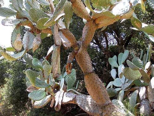 Plentiful cactus in lower canyon
 The fruit are called "tunas" in Spanish and are delicious
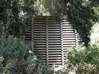 Debris dam for flood control
The two mile stretch along the trail makes for a quick, shaded hike or run. In addition, hard core recreational mountain bikers know the El Prieto Canyon Trail as one of the most technically challenging mountain bike trails in the San Gabriel Mountains and, some would say, in all of Southern California.
The canyon trail entry point is at about 1,100 feet elevation and the trail tops out at about 2,000 feet where it meets the Brown Mountain fireroad, making for a moderate 900 feet of gain.
Entry Points
From Windsor Ave./Jet Propulsion Laboratory Trailhead
The Gabrielino Trail begins as a paved road dropping gently into the Arroyo Seco area. The trail crosses several bridges spanning the Arroyo Seco River and eventually becomes a dirt road. In about a mile and a half, you will come to a signed junction. Go right towards Brown Mountain Road.
 El Prieto Canyon Trail
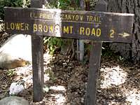 Start of trail at canyon bottom
From the junction, you will start ascending along El Prieto Creek and, in about ½ mile from the junction, you will come to the signed El Prieto Canyon Trail. Take a right onto the trail to begin your ascent of the lower canyon.
From Millard Campground Trailhead
Alternatively, you can opt to start at the top of the canyon. To do it this way, get to the Millard Campground Trailhead. Walk past the fire road gate the short distance to Millard Canyon Campground. At the upper end of the campground, Millard Creek runs across the fire road. Past the creek, take the fire road that goes left for about ¾ miles. At this point you will cross El Prieto Creek (usually just a trickle of water runs over the road) where the road makes a sharp left. About 100 yards past the sharp left, look for the trail on your left descending into El Prieto Canyon.
 Start of trail at upper end of lower canyon
Getting There
Windsor Ave./Jet Propulsion Laboratory TrailheadGoing west on the 210 Freeway, take the Windsor Avenue exit and go right (north) on Windsor Ave. In about 1 mile, you will come to a paved parking area on your left overlooking the facilities of the California Institute of Technology’s Jet Propulsion Laboratory (“Windsor Ave./JPL lot”). Park here or, because this lot fills rapidly on weekends, on any of the nearby residential streets. No Adventure Pass is necessary to park. About 50 yards north of the parking lot is the beginning of the southern terminus of the Gabrielino Trail.
Millard Canyon Trailhead
From the 210 Freeway exit at Fair Oaks Ave. and take Fair Oaks north toward the mountains. At Loma Alta Drive, turn left and proceed about ½ mile to Chaney Trail Drive. The intersection is marked by a flashing yellow traffic signal. Turn right onto Chaney Trail Drive and ascend to Sunset ridge where you will come to a junction. To get to Millard Canyon Trailhead and campground, go left here and down the road about a mile to the trailhead parking lot.
Red Tape
No Adventure Pass is required to park at the Windsor Ave./JPL trailhead. A pass is required to park at the Millard Campground Trailhead. You cannot purchase a pass at this trailhead so get one beforehand. Besides certain Angeles Forest stations, most sporting goods stores sell these passes ($5 daily or $30 for one year). The closest such store in this area is Sports Chalet along Foothill Blvd. in La Canada.No permits are necessary for hiking in the San Gabriel front range.
Camping
Millard Canyon Campground is a developed public campground just two hundred yards from the Millard Canyon trailhead. There is also camping at the Gould Mesa Campground along the Arroyo Seco River in an area west of El Prieto Canyon.Other Information
USGS 7.5 Topo: PasadenaBecause San Gabriel Mountain canyon creeks are a prime habitat for poison oak, consider wearing long pants and long sleeves to minimize your exposure to this plant’s rash-inducing oils.
Even during very dry summer seasons, there is always some water in El Prieto Creek. If you need to dip into this source, be sure to treat it.
 The trail is techncially challening for bikes
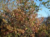 Ubiquitous plant in San Gabriels
External Links
Angeles National Forest
Adventure Pass information