
-
 5073 Hits
-
 79.54% Score
-
 11 Votes
|
|
Mountain/Rock |
|---|---|
|
|
49.14997°N / 7.77110°E |
|
|
Sport Climbing, Toprope |
|
|
Spring, Summer, Fall |
|
|
758 ft / 231 m |
|
|
Overview
 Schillerfelsen western summit in front of Dahn Schillerfelsen western summit in front of Dahn |
The town of Dahn is the centre of the Südpfalz climbing area with its 50 odd sandstone climbing cliffs. Therefore the area surrounding the town is called Dahner Felsenland, which translates to Dahn rock country. A fitting name. All around the town the hills and mountains sprout rocks of different sizes, most of which are regularly climbed. Hochstein and Jungfernsprung are located in the town centre and Lämmerfels towers above the houses in the south-west. In the west of Dahn a whole set of climbing crags lures climbers, some of them popular like Blitzfels and Pfaffenfels some of them not solitary like Büttelwoogfels, Sängerfels and Schillerfelsen.
The latter are located directly above the westernmost houses of Dahn. Named after Germany's greatest poet, Friedrich Schiller (don't make mistakes - he never was in town; rather the rocks were named after the street which leads by them) the formation consists of four rocks: the main summit in the east, tall and of most interest with respect to climbing; the western summit rising only several metres to the west; the twin peaked massif, a long ridge which vanishes beneath the dense forest of Pfälzerwald.
 Main summit Main summit |  Western summit Western summit |  Main summit Main summit |  Main summit Main summit |
The most interesting feature is the main summit. Depending on your viewpoint it is a rock with a large window or an arch. A solid western pillar carries most of the weight, while a smaller tilted pillar rises directly from the last houses of Dahn. Like most of the Südpfalz crags, Schillerfelsesn is overgrown and the north face shows a thick over of moss and lichen, indicating the less than perfect German weather. Schillerfelsen is located directly opposite to Jungfernsprung on the other side of Dahn and the Wieslauter Valley, of both of which it offers very picturesque views.
Climbing Routes on Schillerfelsen
 Schillerfels main summit with Jungfernspring in the background
While Schillerfelsen are visited quite often, thanks to their proximity to the town of Dahn and the Felsenland hiking trail, which runs right between the towers, the rocks are rarely climbed. Climbers usually choose the more obvious destinations of Hochstein, Pfaffenfels and Blitzfels to the south. Still some routes exist, mainly on the main and western towers. The massif towers both only have the normal route rated grade I.
The following table has links to the tour database of the PK, where you can find the grades for the free routes plus additional information. Here is the link to the complete route database.
 Main summit Main summit |  Western summit Western summit |  Main summit Main summit | 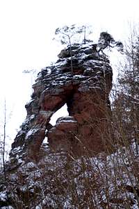 Main summit Main summit |
| Feature | Routes link | Summary |
| Schillerfelsen Main Summit | Schillerfelsen Hauptgipfel | 6 routes with variations ranging from 3 - 6+ |
| Schillerfelse Western SummitMassif | Schillerfelsen Westgipfel | 4 routes with variations ranging from 1 - 4+ |
Getting There
 Schillerfelsen above the last houses of Dahn
Schillerfels is located at the western outskirts of Dahn, directly facing Jungfernfels. However, the wide Wieslauter Valley is in between. Dahn is located right in the middle of the Pfälzerwald area and access routes are rather long. The closest airports are Frankfurt and Stuttgart.
From Frankfurt
There are two possible routes which both take equally long- Via Ludwigshafen
- From Frankfurt take motorway A5 southward to Darmstadt.
- There change to A67 south.
- At Viernheimer Dreieck turn onto A6 west.
- Leave it at Frankenthaler Kreuz for A61 south.
- At Mutterstädter Kreuz take A65 south until you reach Landau.
- At Landau turn on B10 west.
- At Hinterweidental turn onto B427 south which will take you to Dahn. In the town centre a sign leads to Felsenland Badeparadies, the public open air pool. Park at the pool parking lot. To reach Schillerfelsen either head back the street (Hasenbergstrasse) until you reach the railway line. Just before turn left onto Ludwigsstrasse, which will lead you right in the vicinity of Schillerfelsen.
- Via Kaiserslautern
- From Frankfurt take motorway A3 west
- At Mönchhofdreieck turn onto A67 south
- At Rüsselsheimer Dreieck take A60 west
- At Kreuz Mainz Süd take A63 south
- At Kreuz Kaiserslautern turn onto A6 west
- At Kreuz Landstuhl turn onto A62 south
- At Pirmasens turn onto B10 east
- At Hinterweidental take B427 south to Dahn
From Stuttgart
- Take motorway A8 to Karlsruhe
- At Karlsruher Dreieck turn north onto A5
- Tke the next exit to head for A65
- At Kandel you can leave onto B427 which will lead you directly to Dahn. However the detour to Landau and B10 will take less time as the roads are better (three or four lanes)
Red Tape
 Argynnis paphia sucking thistle honey
Yes, there is red tape and lots of it. The sandstone of Südpfalz forms lots of caves and overhangs. Though this makes it most interesting for climbers, two species of birds of prey compete for this habitat: the peregrine falcons and the eagle owls. Both are endangered and wherever there is a eagle owl pair found nesting in the sandstone the crag will immediately be closed. Generally this closure lasts from the beginning of each year through Aug. 1st. If breeding is not successful the closures will be cancelled even before that date. For a list of closures see the Closure List of PK. The Schillerfelsen are so close to the nearest houses of Dahn, that usually birds don't nest there. However, please adhere to "stop signs" if there are any.
The use of magnesia is not allowed in the whole Südpfalz region. This is rather a directive or an arrangement than an outright law. Thus you probably will get away with using it but do so only when absolutely necessary. Magnesia closes the pores which you find in the sandstone and together they form a smooth surface which will get very slippery in wet conditions. The rule of thumb is to use magnesia in the highest difficulty sections and only extremely sparingly.
A list of guidelines can be found here (in German).
Parking: The parking lots near the public pool of Dahn are free. However, they are not public and you shouldn't stay after nightfall.
Accommodation
In the town of Dahn you can find numerous hotels or apartments. Have a look at the tourist information site for more info. There are two campgrounds, one at Neudahner Weiher one in nearby Bruchweiler-BärenbachWeather Conditions
Maps & Books
Maps
As for maps there is a good overview map (1:50000) by Kompass Verlag but the best ones are the official topographic maps by the state government of Rheinland Pfalz, scaled 1:50000, 1:25000 and 1:5000. All official maps can be found on the web page of Landesvermessungsamt Rheinland Pfalz
1:50000
- Naturpark Pfälzer Wald
Kompass Map WK766
ISBN: 3-85491-523-3
- Pirmasens Süd<
LVA RLP Map L6910
ISBN: 3-89637-193-2
1:25000
- Dahn
LVA RLP Map 6812
ISBN: 3-89637-147-9
Books
There are a number of climbing guidebooks on the region of Südpfalz. The best ones, however, have been published privately and are sold only in selected bookshops of the region.
- Hiking
- Pfälzerwald
B. & J.-Th. Titz
Rother Verlag
ISBN: 3-7633-4268-0 - Klettern im Buntsandstein
U. Daigger, H.-J. Cron
Westpfälzische Verlagsdruckerei St. Ingbert
ISBN: 3-00-0155457-4
- Pfalz ++, Klettern im Buntsandstein
R. Burkard, P. Weinrich
Published privately
- Klettern im Naturpark Pfälzerwald
Naturfreunde Lambrecht
Published privately - Pfalz & Nordvogesen en bloc
A. Wenner, Y. Corby, I. Bald
Panico Verlag
ISBN: 3-936740-19-4
  Climbing Guidebook |
Climbing