
-
 4278 Hits
-
 80.96% Score
-
 13 Votes
|
|
Mountain/Rock |
|---|---|
|
|
49.16400°N / 7.76903°E |
|
|
Sport Climbing |
|
|
Summer, Fall |
|
|
1007 ft / 307 m |
|
|
Overview
 Falkenstein east face Falkenstein east face |
Sunset can be magical in the Pfälzerwald Area. Suddenly the sky tuns red and within the huge forests lights flare up. The red sandstone formations turn even redder and the shadows by the brightly leaved trees weave hallucinating patterns on the rocks. The moment quickly fades as the sun sets behind the next mountain and suddenly everything turns grey, then black.
One such moment occurred to me several days ago on the north ridge of Gerstberger Kopf, one of the tree covered mountains of the Pfälzerwald area. Located between the village of Hinterweidenthal and the town of Dahn, it is home to several of the sandstone formations, which made the region famous. Mauchendellfels and Weigelfels on the western slopes can already be seen from the road to Dahn but the main destination to get to are four towers on top of the ridge: Rabensteine.
 |  |  |  |
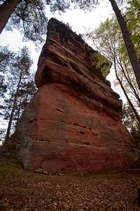
The four rocks standalone towers, separated by a distance of about 200m each. The first (westernmost) one in line is Taubenstein (Pigeon Rock), a big, square tower with narrow west and east faces. It was first climbed in 1911 by climbing pioneers Fritz and Theo Mann, who wound their way up from the east face through the north face to the west face and up to the summit. Later that same year they established what today is the normal route through the east and west faces. In 1922 two other brothers, Wilhelm and Otto Matheis established the third route, this time through the north face.
 |  |  |  |
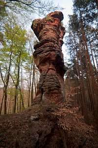
Number two on the ridge is Falkenstein (Falcon Rock), even bigger than Taubenstein and not as square looking. The same climbers established the routes, all of them in 1921 / 1922. There is a big overhang right beneath the summit through which the route "Rundquergang" runs, circling the whole tower. It was established by the Matheis bros again.
 |  |  |  |
The third tower is Rabenstein (Raven Rock), much smaller than the former two and with only a handful of routes. Again it was Fritz Mann, who helped establish them, more than 5 decades after the Taubenstein climbs in 1967. This time his partner was Sepp Schmaus. Even further to the east you can find the fourth and smallest tower, Häherfels (Jaybird Rock), which saw its first routes come up during the 1970s.
The four Rabensteine towers, mainly Taub and Falk the biggest ones have always attracted climbers. However, the long pathless climb to the ridge from the base of Gerstberger Kopf ensures that there is not much traffic on any given day. Four towers offer about 20 routes with difficulties of up to 9-.
Climbing Routes on the Rabensteine Towers
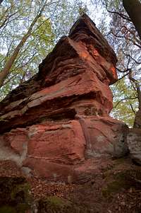
 Taubenstein north-west face
The following table has a link to the tour database of the PK, where you can find the grades for the free routes plus additional information. Here is the link to the complete route database.
| Feature | Routes link | Summary |
| Rabensteine, Taubenstein | Taubenstein | 8 routes with variations ranging from 5- - 9 |
| Rabensteine, Falkenstein | Falkenstein | 6 routes with variations ranging from 6 - 9- |
| Rabensteine, Rabenstein | Rabenstein | 3 routes with variations ranging from 2 - 5+ |
| Rabensteine, Häherfels | Häherfels | 4 routes ranging from 3 - 6 |
Getting There
The four Rabensteine towers are located on a ridge between Hinterweidenthal and Dahn, the NW ridge of Gerstberger Kopf. There is ample parking space in an industrial zone immediately to the north of the ridge, to the east of B427, the highway which connects Hinterweidenthal with Dahn.From Frankfurt
There are two possible routes which both take equally long- Via Ludwigshafen
- From Frankfurt take motorway A5 southward to Darmstadt.
- There change to A67 south.
- At Viernheimer Dreieck turn onto A6 west.
- Leave it at Frankenthaler Kreuz for A61 south.
- At Mutterstädter Kreuz take A65 south until you reach Landau.
- At Landau turn on B10 west.
- At Hinterweidental turn onto B427 south.
- After the intersections to Salzwoog and Neudahner Weiher to the left there is an industrial zone "Neudahn 1". Park kcar here and head up the steep slopes to the south.
- Via Kaiserslautern
- From Frankfurt take motorway A3 west
- At Mönchhofdreieck turn onto A67 south
- At Rüsselsheimer Dreieck take A60 west
- At Kreuz Mainz Süd take A63 south
- At Kreuz Kaiserslautern turn onto A6 west
- At Kreuz Landstuhl turn onto A62 south
- At Pirmasens turn onto B10 east
- At Hinterweidental take B427, then follow the instructions above
From Stuttgart
- Take motorway A8 to Karlsruhe
- At Karlsruher Dreieck turn north onto A5
- Take the next exit to head for A65
- At Kandel you can leave onto B427 which will lead you directly to Dahn. However the detour to Landau and B10 will take less time as the roads are better (three or four lanes).
- At Hinterweidental take B427, then follow the instructions above
Red Tape
Rabensteine are often closed to climbing in the first half of the year. 2009 seems to be an exception as no peregrines or eagle owls are nesting on the cliffs.The sandstone of Südpfalz forms lots of caves and overhangs. Though this makes it most interesting for climbers, two species of birds of prey compete for this habitat: the peregrine falcons and the eagle owls. Both are endangered and wherever there is a eagle owl pair found nesting in the sandstone the crag will immediately be closed. Generally this closure lasts from the beginning of each year through Aug. 1st. If breeding is not successful the closures will be cancelled even before that date. For a list of closures see the Closure List of PK. The Schillerfelsen are so close to the nearest houses of Dahn, that usually birds don't nest there. However, please adhere to "stop signs" if there are any.
The use of magnesia is not allowed in the whole Südpfalz region. This is rather a directive or an arrangement than an outright law. Thus you probably will get away with using it but do so only when absolutely necessary. Magnesia closes the pores which you find in the sandstone and together they form a smooth surface which will get very slippery in wet conditions. The rule of thumb is to use magnesia in the highest difficulty sections and only extremely sparingly.
A list of guidelines can be found here (in German).
Accommodation
There are all kinds of accommodation to be found at Dahn: campgrounds, youth hostel, rooms and apartments:Dahn tourist information site
The closest campground is between Hinterweidenthal and Dahn at Neudahner Weiher just across B 247 from the crags.
Weather conditions
Maps & Books
Maps
As for maps there is a good overview map (1:50000) by Kompass Verlag but the best ones are the official topographic maps by the state government of Rheinland Pfalz, scaled 1:50000, 1:25000 and 1:5000. All official maps can be found on the web page of Landesvermessungsamt Rheinland Pfalz
1:50000
- Naturpark Pfälzer Wald
Kompass Map WK766
ISBN: 3-85491-523-3
- Pirmasens Süd<
LVA RLP Map L6910
ISBN: 3-89637-193-2
1:25000
- Dahn
LVA RLP Map 6812
ISBN: 3-89637-147-9
Books
There are a number of climbing guidebooks on the region of Südpfalz. The best ones, however, have been published privately and are sold only in selected bookshops of the region.
- Hiking
- Pfälzerwald
B. & J.-Th. Titz
Rother Verlag
ISBN: 3-7633-4268-0 - Klettern im Buntsandstein
U. Daigger, H.-J. Cron
Westpfälzische Verlagsdruckerei St. Ingbert
ISBN: 3-00-0155457-4
- Pfalz - Klettern im Buntsandstein des Pfälzer Felsenlands
J. Richter, S. Tittel
Panico Alpinverlag
ISBN: 978-3-936740-41-7
- Pfalz ++, Klettern im Buntsandstein
R. Burkard, P. Weinrich
Published privately
- Klettern im Naturpark Pfälzerwald
Naturfreunde Lambrecht
Published privately - Pfalz & Nordvogesen en bloc
A. Wenner, Y. Corby, I. Bald
Panico Verlag
ISBN: 3-936740-19-4
  Climbing Guidebook |
Climbing