

-
 9862 Hits
-
 89.39% Score
-
 29 Votes
|
|
Area/Range |
|---|---|
|
|
47.20530°N / 11.11562°E |
|
|
Hiking, Mountaineering, Trad Climbing, Scrambling, Via Ferrata, Skiing |
|
|
Spring, Summer, Fall, Winter |
|
|
10479 ft / 3194 m |
|
|
1 - Overview
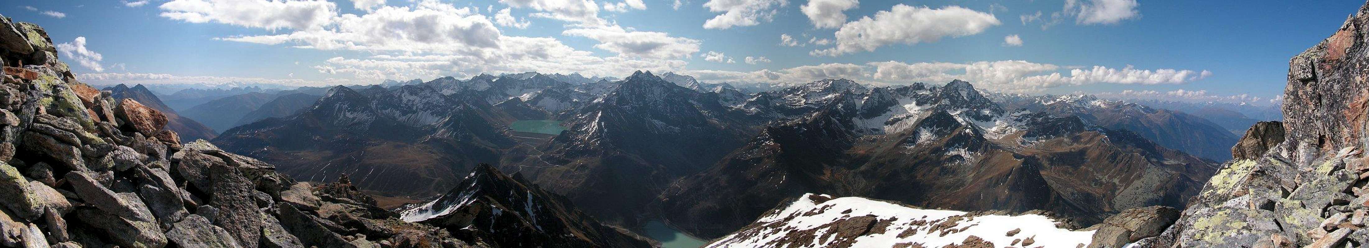
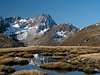
 Grubenwände above Gleirschferner by mvs Grubenwände above Gleirschferner by mvs |
Named after Sellraintal Valley, which itself is named after the village of Sellrain, the Sellrainer Berge Group (Sellrain Mountains) is the largest subgroup of the Stubai Alps. It consists of three distinctive and well separated parts, one in the north, two to the south of the valley which gave its name to the range. Sellrainer Barge stretch almost across the whole width of the Stubai Alps – between Ötztal and Wipptal, with the small Kalkkögel Group, standing as a last separator from the latter Valley. The mountains of the group, especially those in the south-western part, reach well over 3000m with Gleirscher Fernerkogel, the highest mountain of the range at almost 3200m.
The northern part of the range is located between the Inntal and Sellraintal Valleys, a broad wedge of mountains, which reach up to 2884m (Rietzer Grießkogel). There are no glaciers in this part of the range, most mountains are formed by eruptive rock (gneiss, granite, porphyry) and most parts of them are grass covered. Most summits can be easily reached and there are several nice panoramic traverses in this group.
The south-western Selrainer Berge stretch between Ötztal Valley in the west and Liesenser Tal in the east. The northern boundary is Sellraintal Valley, while the southern boundary is less bell defined. From Liesenser Tal, Längentaler Bach and Ochsenkar lead to the saddle of Zwieselbachjoch (east to west). Here the boundary turns north along Zwieselbachtal, which joins Horlachtal, again running westward. Most of the 3000m summits here have small glaciers on their north sides. Around Kühtai and Finstertal Reservoir quite a number of mountains can be climbed, while the remainder of te group is remote and rather unpopular.
The south-eastern Sellrainer Berge, the smallest of the three subranges, stretch between Liesenser Tal in the west and Senderstal in the east (separating it from Kalkkögel). The northern boundary is Sellraintal, while in the south Obernbergtal and Großes Horntaler Joch separate it from the Alpein Group. The southernmost summit, Hohe Villersspitze is the subrange’s highpoint at 3092m) and carries the only glacier on its north face, Fotscher Ferner. The northern part of this subrange consists of harmless, grass-covered mountains while the south already bears resemblance to the Alpein Group in the centre of the Stubai Alps.
2 - Sellrainer Berge on SP

3 – Nördliche Sellrainer Berge
  |
-
The northernmost part of the Stubai Alps is separated from the rest of the range by the deep Sellrain Valley. This subgroup, the Northern Sellrain Group stretches across almost the whole width of the range, starting from the Ötztal Valley in the West to the village of Kematen, west of Innsbruck. To the north it is bounded by the Inn Valley, to the south by the Sellrain Valley. Mountains in the group do not reach more than 3000m but with the valley elevations between 700m and 1500m they all are impressive (and strenuous) hiking/climbing destinations.
- Faltegartenkögele (2182m)
- Pirchkogel (2828m)
![]()
- Kühtaier Grießkögel (2666m, 2673m)
- Irzwände (2757m)
- Hochwanner (2452m)
- Hochalter (2673m)
- Mugkogel (2688m)
- Kreuzjochkogel (2750m)
- Bachwandkopf (2758m)
- Rietzer Grießkogel (2884m)
- Hocheder (2798m)
- Narrenkopf (2450m)
- Schafmarebenkogel (2651m)
- Schartenkogel (2603m)
- Seejoch (2808m)
![]()
- Peiderspitze (2808m)
![]()
- Schloßköpfe (2725m, 2661m)
- Brechten (2419m)
- Koflerspitzen (2641m)
- Mitterkogel (2510m)
- Weißstein (2641m)
- Roßkogel (2649m)
![]()
- Rangger Köpfl (1939m)


4 – Südliche Sellrainer Berge
 |
In terms of the sheer number of mountains the southern Sellrainer Berge is one of the largest subgroups of the Stubai Alps. Like its northern counterpart it stretches between the Ötztal and Senderstal Valleys. The northern boundary is Sellrain Valley while to the south it stretches right into the center of the range. At its southern end the mountains of the subgroup are glaciated and here a large area has been declared "Ruhezone" - an sanctuary for man and beast. Several smaller valleys lead into the subgroup and facilitate the access to the central part. This part of Sellrainer Berge generally is separated into two parts, the separator bein Liesenser Tal, which stretches southwards from Gries.
- Zwölferkögele (2229m)
- Wetterkreuz (2578m)
![]()
- Wörglgratspitze (2722m)
- Hintere Karlesspitze (2636m)
- Vordere Karlesspitze (2569m)
- Schafzoll (2394m)
- Maningkogel (2892m)
- Acherkogel (3008m)
![]()
- Habicher Wand (2176m)
- Wechnerkögel (2955m)
- Wechnerwand (2852m)
- Roter Kogel (2825m)
- Mittertaler Köpfe / Türme (2640m, 2526m, 2506m, 2475m)
- Hochwanner (2456m)
- Hochbrunnachkogel (2875m, 2888m)
- Hochreichkopf (3008m)
- Hohe Wasserfalle (3002m)
- Peistakogel (2643m)
- Niederer Plattkogel (2737m)
- Hoher Plattkogel (2790m, 2735m)
![]()
- Gamezkogel (2960m)
- Sulzkogel (3016m)
![]()
- Mittagsköpfe (2895m, 2934m)
- Zwölferkogel (2988m)
![]()
- Östlicher Gamezkogel (2942m)
- Kraspesspitze (2953m)
- Schöllekogel (2900m)
- Steintalspitze (2741m, 2743m)
- Pockkogel (2807m)
- Gaißkogel (2820m)
- Weitkarspitze (2948m, 2947m)
- Zwiselbacher Roßkogel (3082m, 3060m)
![]()
- Gleirscher Roßkogel (2994m)
- Grubenkarspitze (3040m)
- Haidenspitze (2973m)
- Räuhengrat (2814m)
- Rotkogel (2760m)
- Mutenkogel (2420m)
- Metzgerstein (2782m)
- Zwiselbacher Grießkogel (3066m)
- Vordere Sonnenwande (3159m)
- Mittlere Sonnenwand (3111m)
- Hintere Sonnenwand (3112m)
- Südliche Sonnenwand (3094m)
- Gleirscher Fernerkogel (3194m)
- Winnebacher Weißkogel (3185m)
![]()
- Zwiselbacher Weißkogel (2961m)
- Grubenwand (3175m, 3165m)
![]()
- Schöntalspitze (3008m)
![]()
- Schöntalwände (2540m, 2615m, 2683m)
- Zischgelesspitze (3005m)
![]()
- Oberstkogel (2767m)
- Sattelschröfen (2890m)
- Lampsenspitze (2875m)
- Hohe Wand (2788m)
- Grieser Grießkogel (2707m)
- Freihut (2640m)
![]()
4.2 - Südöstliche Sellrainer Berge
- Hohe Villerspitze (3092m)
![]()
- Lisener Villersspitze (3026m)
- Hohe Röte (2828m)
- Gallwieser Mittergrat (2841m)
- Roter Kogel (2834m)
- Hühnereggen (2725m)
- Wentenspitze (2644m)
- Fotscher Windegg (2577m)
- Gamskögele (2216m)
- Wildkopf (2742m)
- Schwarzhorn (2812m)
- Steinkogel (2589m)
- Gamskogel (2659m)
- Schafkogel (2572m)
- Schafleger (2405m)
- Angerbergkopf (2399m)
- Breitschwemmkogel (2264m)
- Grieskogel (2158m)
4.1 - Südwestliche Sellrainer Berge


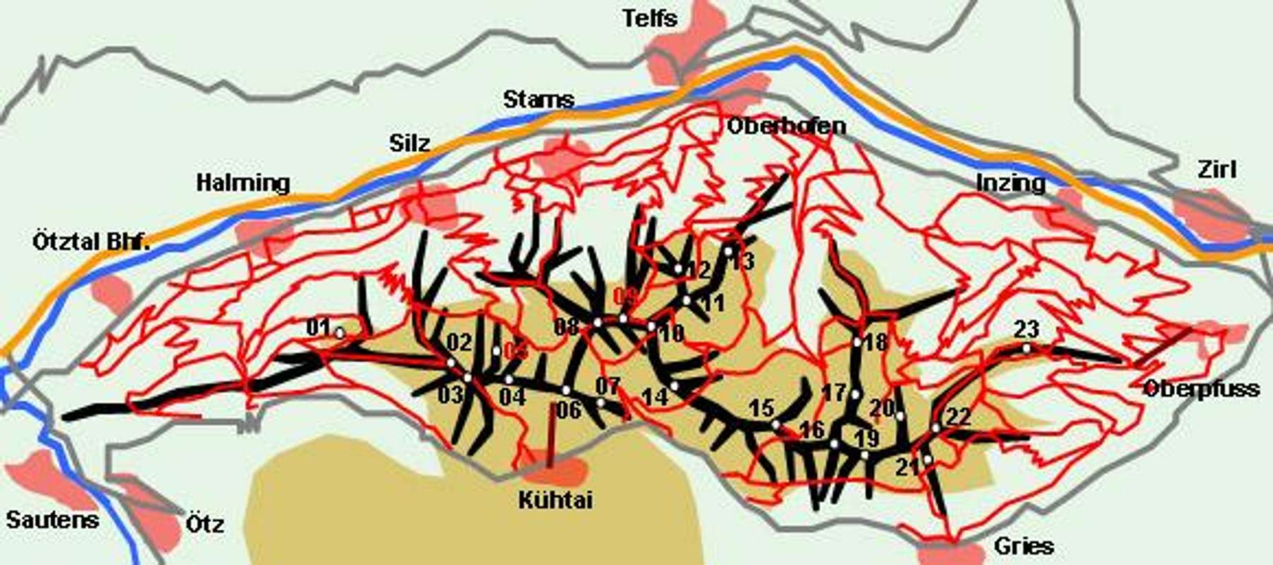
5 - Getting There
Sellrainer Berge are located in the vicinity of Innsbruck and thus very quickly to be reached. The northern part can be reached from motorway A12 directly, while the southern part is best reached via Sellrain Valley.
- From Innsbruck follow motorway A12 to the west
- At the exit Kematen leave and follow the signs to Gries / Sellrain and Kühtai.
- Alternatively drive through to the Ötztal exit and take B186 to Ötz where you follow the signs to Kühtai.
6 - Accommodation
As for mountain huts, you can find the complete list on the Stubai Alps main page
7 - Red Tape
Much of the southern Sellrainer Berge has been declared “Ruhegebiet Stubaier Alpen”, a nature preserve, in which any type of construction is not permitted. In any case trails should not be left and the usual restrictions apply.8 - Weather Conditions
9 - Maps & Books
9.1 - Maps
Kompass has some very good overview maps, scaled 1:50000 which show all the necessary trails but don't go into too much detail:
- Stubaier Alpen
Kompass Map WK83
1:50000
ISBN: 3-85491-092-4
- Innsbruck - Brenner
Kompass Map WK36
1:50000
ISBN: 3-85491-040-1
- Imst – Telfs - Kühtai
Kompass Map WK35
1:50000
ISBN: 3-85491-039-8
Better are the maps by the German Alpine Club, available for the nothern (Austrian) part of the Stubai Alps. They are scaled 1:25000 and can be obtained by The DAV-Shop (look under "Zentralalpen"). Both hiking and ski-touring trails are marked on these maps.
- 31/2 Stubaier Alpen, Sellrain
9.2 - Maps Online
9.3 - Books
- Stubaier Alpen
W. Klier
Alpenvereinsführer
Rother Verlag
ISBN: 3-7633-1271-4
- Rund um Innsbruck
W. Klier
Rother Verlag
ISBN: 978-3-7633-4170-2
- Stubai - Wipptal
W. Klier
Rother Verlag
ISBN: 3-7633-4172-2
- Ötztal
H. & W. Klier
Rother Verlag
ISBN: 3-7633-4094-7