1 - Overview
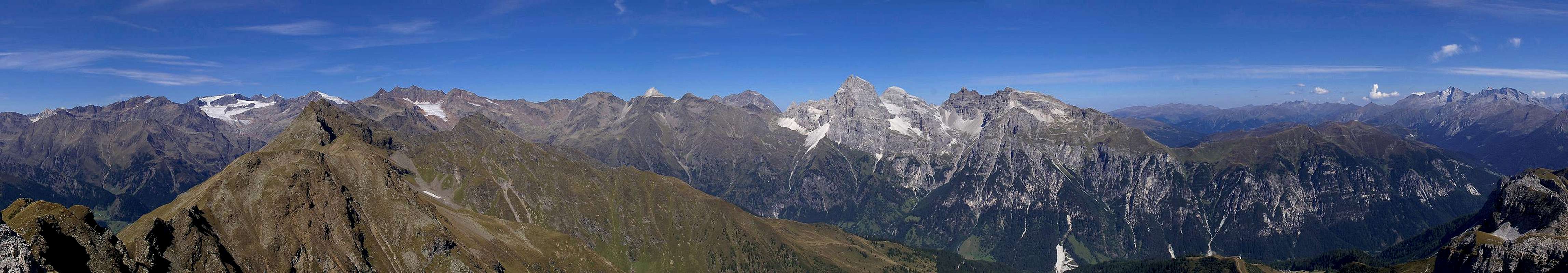
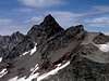
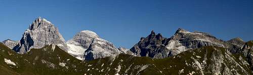
![Schwarzwandspitze (3353m), Hohes Eis (3392m), Sonklarspitze (3467m), Pfaffenschneid (3230m), Zuckerhütl (3507m) und Wilder Pfaff (3456m)]() Schwarzwandspitze, Hohes Eis, Sonklarspitze, Pfaffenschneid, Zuckerhütl, Wilder Pfaff Schwarzwandspitze, Hohes Eis, Sonklarspitze, Pfaffenschneid, Zuckerhütl, Wilder Pfaff |
The main ridge of the
Stubai Alps, not surprisingly, is the central part of the mountain group. It also is the highest part with
Zuckerhütl, the highest mountain, located in its west. Like the main ridges of the neighbouring mountain groups, the
Ötztal and
Zillertal Alps it part of the Alpine Main Ridge and still shows large glaciers. Since WW I, the border between Italy and Austria has run across this ridge but with the advent of the EU and the Schengen treaty this fact has lost much importance. Stubaier Hauptkamm is located between the road passes of
Timmelsjoch / Passo del Rombo and
Brenner / Brennero and thus - at its fringes - can be easily reached. Access to central parts starts from the valleys in north and south and can be lengthy.
Geologically the
Stubai Alps Main Ridge is far more interesting than its neighbours to the east and west. In its western and central parts high glaciated mountains, which are made up from eruptive rock - granite and gneiss - dominate. In its eastern part limestone mountains "take over". Finally in the very east the lowest mountains of the subgroup have the appearance of round-topped hills though even their summits are located above the timber line and easily reach more than 2000m.
Consequently, in the different sections different activities dominate. In the west you'll find a lot of ski runs, especially north of the main ridge. The lifts and cable-cars, which serve these runs even operate during the summer and you'll find skiers there all year long. The lifts, however, also facilitate access to the remote glacier peaks, shortening access times dramatically. Therefore, in most cases the mountains are climbed from the north.
In the central and eastern parts, where limestone mountains dominate, activities are quite different. In the
Tribulaun Group climbing and ferrata hiking are the main activities. The group is very close with a handful of high summits, which are made up of dolomite rock. In fact
Geodat Dolommieu discovered this kind of rock at the base of
Pflerscher Tribulaun. It was named after him and later the name was taken over for the huge ranges to the south-west of the place where the discovery took place. Interestingly, the
Tribulaun Group today is not considered to belong to the
Dolomites.
The very eastern summits of the
Stubai Alps Main Ridge are hills, which are very popular among hikers. Views are extraordinary but still access routes can be very long and cover a lot of elevation gain. Since during WW II this part of the ridge was fortified, old support roads snake their way op to
Hoher Lorenzen and
Grubenkopf. They are very popular among mountain bikers. In addition panoramic high trails run along the slopes of the ridge high above the valleys on both sides, which also are popular among hikers and bikers.
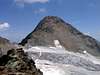
2 - Stubaier Hauptkamm on SP
Stubaier Hauptkamm as seen from the main summit of Telfer Weissen |
- Western Main Ridge
- Central Main Ridge
- Eastern Main Ridge
3 - The Summits
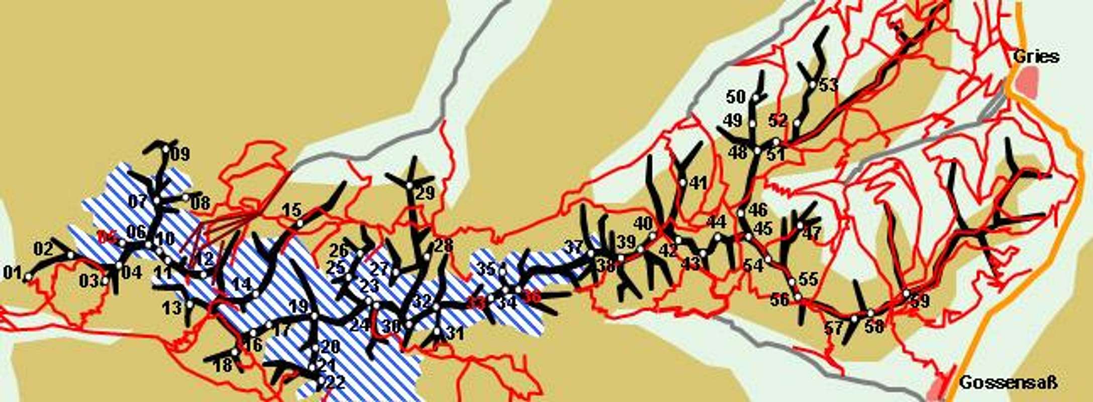
![]() Schematic Map of Stubaier Hauptkamm
Schematic Map of Stubaier Hauptkamm |
3.1 - Western Main Ridge
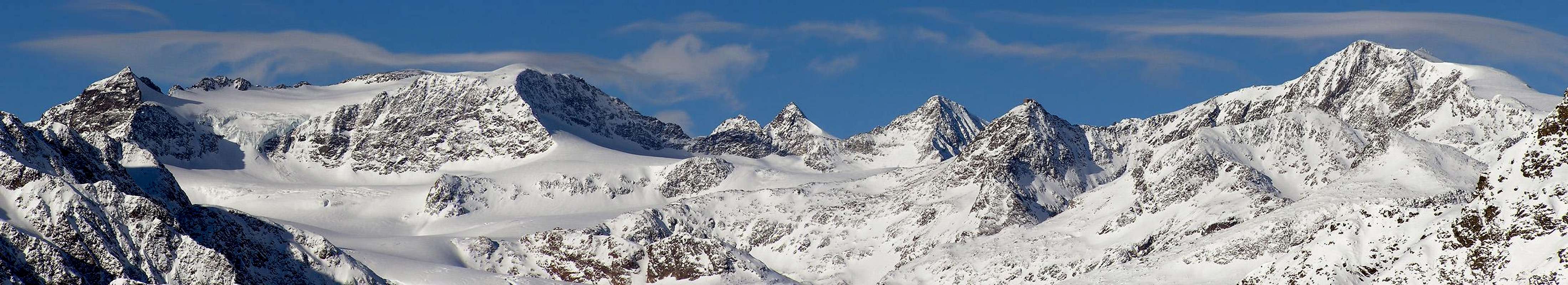
The summits of the central main ridge as seen from Wetterspitze (by Victor Stuffer) |
- Hoher Söldenkogel (2975m)
- Durrnkögele (3112m)
- Hoher Nebelkogel (3211m)
- Warenkarseitenspitze (3345m)
- Windacher Daunkogel (3351m)
- Westlicher Daunkogel (3300m)
- Hinterer Daunkopf (3225m)
- Vorderer Daunkopf (2882m)
- Nördlicher Daunkogel (3076m)
- Östlicher Daunkogel (3332m)
- Stubaier Wildspitze (3340m)
- Schaufelspitze (3333m)
- Schlußgrubenkogel (3211m)
- Aperer Pfaff (3351m)
- Großer Trögler (2902m)
- Pfaffenschneide (3498m)
- Zuckerhütl (3505m)
- Geißkogel (3129m)
- Wilder Pfaff / Cima del Prete (3458m)
- Sonklarspitze / Cima di Malavalle (3467m)
- Hohes Eis / Sopravedretta (3388m)
- Schwarzwandspitze / Croda Nera di Malavalle (3358m)
3.2 - Central Main Ridge
![Aglsspitze (3194m), Feuersteine (3250m, 3267m), Schneespitze (3166m)]() Aglsspitze, Feuersteine, Schneespitze
Aglsspitze, Feuersteine, Schneespitze - Wilder Freiger / Cima Libera (3418m)
- Signalgipfel (3392m)
- Aperer Freiger (3262m)
- Sulzenaukogel (2947m)
- Gamsspitzl (3052m)
- Urfallspitze (2808m)
- Mairspitze (2781m)
- Roter Grat / Cresta Rossa (3099m)
- Geißwandspitze (2970m)
- Hohe Wand / Pareta Alta (2973m)
- Feuersteine / Montarsi (3245m, 3268m)
- Pflerscher Hochjoch / Giogo Alto di Fleres (3166m)
- Aperer Feuerstein (2968m)
- Schneespitz / Monte della Neve (3178m)
3.3 - Eastern Main Ridge
![The principal summits of the Tribulaun Group]() Tribulaun Group
Tribulaun Group - Schafkampspitze / Cima delle Pecore (3016m)
- Weißwandspitze / Parete Bianca (3016m)
- Hoher Zahn / Dente Alto (2924m)
- Pflerscher Pinggl / Pico di Fleres (2766m)
- Garklerin (2470m)
- Goldkappl (2793m)
- Pflerscher Tribulaun / Tribulaun (3096m)
- Gschnitzer Tribulaun / Tribulaun di Dentro (2946m)
- Schwarze Wand / Monte del Ferro (2917m)
- Eisenspitze (2673m)
- Obernberger Tribulaun (2780m)
- Kreuzjöchl (2651m)
- Hohes Tor (2636m)
- Zeisspitze (2220m)
- Muttenkopf (2637m)
- Am hohen Kreuz (2485m)
- Rötenspitze (2481m)
- Nördlicher Roßlauf / Il Cavallo (2881m)
- Pfeiferspitzen / Il Fumante (2793m)
- Südlicher Roßlauf / Il Cavallo di Porto (2378m)
- Grubenkopf / Monte delle Cave (2337m)
- Geiserskragen / Cima degli Avvoltoi (2309m)
- Hoher Lorenzen / Monte San Lorenzo (2313m)
4 - Getting There
General Access to Stubaier Hauptkamm is rather easy since it is wedged between the two road passes of
Timmelsjoch / Passo del Rombo in the west and
Brenner / Brennero in the east. However, to reach the remote summits on the ridge you need to drive deep into the valleys. Here access is much easier from the eastern side (Brenner Motorway) since most of the valleys start from there. Western access from Timmelsjoch is restricted to the mountains immediatelly in its viciinity.
- Access to Timmelsjoch / Passo del Rombo
- From the north
- Take A12, Inntalautobahn, from Innsbruck westward in direction Bregenz
- At the exit Öz, Öztal leave onto B186 through Ötztal
- The road will take you evenntually to Timmelsjoch / Passo del Rombo
- At Sölden, before the ascent to the pass begins, the Windache Valley turns off to the left, which is a possible access valley for Stubaier Hauptkamm
- From the South
- Take SS38 from Bozen / Bolzano to Meran / Merano
- In Meran switch to SS44 direction Timmelsjoch, Jaufenpass
- In St Leonhard / St Leonardo switch to SS44b to Timmeslsjoch / Passo del Rombo.
- Access to Brenner / Brennero
- From the north
- Take Brenner Motorway A13 from Innsbruck
- The Stubai-, Gschnitz- and Obernberg-Valleys turn off from the motorway north of the border
- The Pflersch Valley / Val di Fleres and Ridnaun Valley / Val Ridnana turn off to the south of the border
- From the South
- Take Brenner Motorway A22 north
- The Pflersch Valley / Val di Fleres and Ridnaun Valley / Val Ridnana turn off to the south of the border
- The Stubai-, Gschnitz- and Obernberg-Valleys turn off from the motorway north of the border
5 - Accommodation
As for mountain huts, you can find the complete list on the
Stubai Alps main page.
6 - Red Tape
Like in the Ötztal Alps there is a "Ruhezone" (=calm zone) around the centre of the Stubai Alps. This means they are off limits for downhill skiing at all times of the year while hiking and climbing (again with the obvious restrictions) is allowed.
Timmelsjoch / Passo di Rombo can be closed at all times of the year due to snowfall. Moreover the road is a toll road which is closed after 8 p.m. Keep that in mind when crossing over to the other side of the border.
7 - Weather Conditions
8 - Maps & Books
8.1 - Maps
8.1.1 - Digital Maps
8.2.2 - Regular Maps
Kompass has some very good overview maps, scaled 1:50000 which show all the necessary trails but don't go into too much detail:
- Stubaier Alpen
Kompass Map WK83
1:50000
ISBN: 3-85491-092-4
- Innsbruck, Brenner
Kompass Map WK36
1:50000
ISBN: 3-85491-040-1
- Passeiertal / Val Passira
Kompass Map WK44
1:50000
ISBN: 3-85491-525-X
Better are the maps by the German Alpine Club, available for the nothern (Austrian) part of the range. They are scaled 1:25000 and can be obtained by
The DAV-Shop (look under "Zentralalpen"). Both hiking and ski-touring trails are marked on these maps. There are three maps:
- 31/1 Stubaier Alpen, Hochstubai
- 31/2 Stubaier Alpen, Sellrain
- 31/3 Stubaier Alpen, Brennerberge
The southern part of the Stubai Alps is covered by the following Tabacco Maps, all also scaled 1:25000:
- 38: Vipiteno-Alpi Brenoie / Sterzing – Stubaier Alpen
- 39: Val Passiria / Passeier Tal
8.2 - Books
- Stubaier Alpen
W. Klier
Alpenvereinsführer
Rother Verlag
ISBN: 3-7633-1271-4
- Ötztal
H. & W. Klier
Rother Verlag
ISBN: 3-7633-4094-7
- Stubai - Wipptal
W. Klier
Rother Verlag
ISBN: 3-7633-4172-2

 13602 Hits
 88.19% Score
 26 Votes
 Schwarzwandspitze, Hohes Eis, Sonklarspitze, Pfaffenschneid, Zuckerhütl, Wilder Pfaff