
-
 3769 Hits
-
 82.48% Score
-
 15 Votes
|
|
Mountain/Rock |
|---|---|
|
|
28.59095°N / 17.83711°W |
|
|
Hiking |
|
|
Spring, Summer, Fall, Winter |
|
|
6076 ft / 1852 m |
|
|
Overview
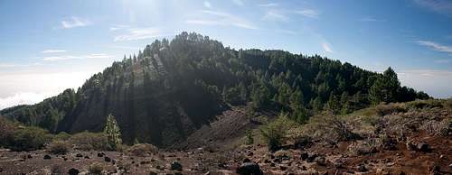 Montaña de los Charcos as seen from the north Montaña de los Charcos as seen from the north |
Cumbre Vieja, the old mountain, is one of the youngest mountain ranges on this planet. Volcanic activity has piled up a broad back of ash and cinder on the island of La Palma among the Islas Canarias in the last 125.000 years. Today you can count 120 craters on the range, which rises from sea level to almost 2000m. It's highest summit, Volcan de la Deseada reaches 1945m. The range forms a single ridge, which runs north to south and steeply drops to its eastern and western sides. In its central part about a dozen summits reach more than 1800m.
 |  |
One of these is Montaña de los Charcos, located in the northern part of the range. After Pico Birigoyo and Montaña la Barquita it is the third of the high mountains as seen from the north. There are two summits, a perfectly shaped cinder cone in the north and a half-circular crater, the actual main summit, to the south. While the north summit is open with little vegetation the south summit is covered with Canarian Pines. Thus summit views are somewhat restricted only leaving a few glimpses to the north and south.
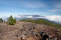
 Summit view Montaña de los Charcos towards the north
Cumbre Vieja can be hiked by the famous Ruta de los Volcanes, a 20km hiking trail across the main ridge of the range. In its northern part the Ruta skips the summits but rather runs by to their north, only climbing the lower western summit of Deseada. However, if you plan some serious elevation difference by constant up-and-down hiking you can also follow the direct ridge which not only offers the best views but also avoids most of the crowds on the Ruta. Montaña de los Charcos usually is climbed that way and offers some of the most tranquil stretches of the whole route. It pays to climb it early in the morning as the usual weather pattern on La Palma calls for trade wind clouds to roll in during the late morning. I hav been up on Cumbre Vieja four times and each time noon brought our hikes to a dead end. In addition to clouds and fog fierce winds can sweep the summits.
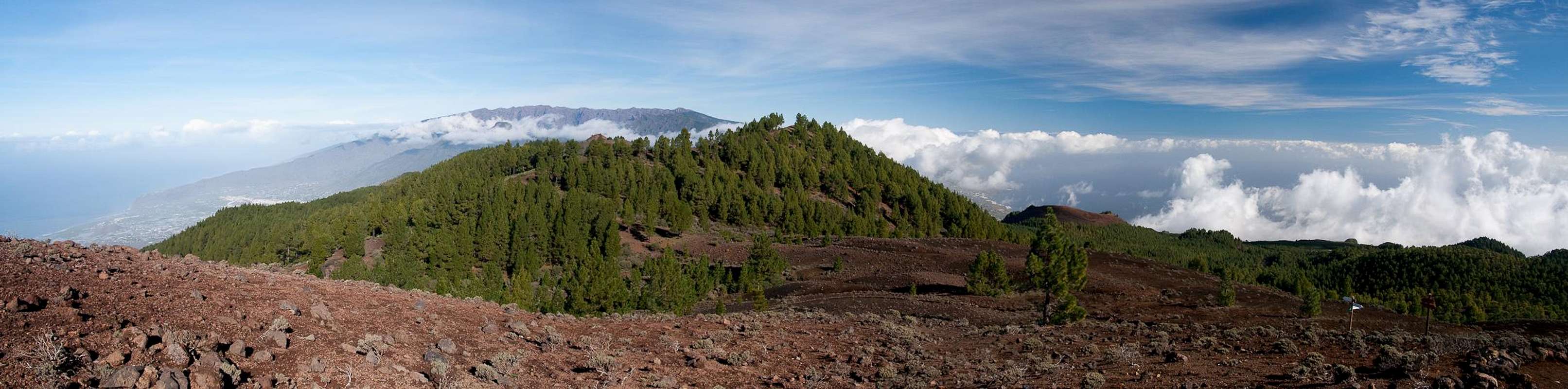
Panoramic View
  |
Getting There
 Cumbre Vieja from its eastern slopes. Montaña de los Charcos in the centre
La Palma, like all the other Canarian Islands can easily be reached from almost all major European airports. The airport is rather small and compared to Tenerife or Gran Canaria air traffic is rather low. There are almost no regular flights but all year round you'll be able to book charter flights.
To reach Rifugio del Pilar head out northward From the airport on LP-1, which you leave at a roundabout, heading in the direction of Los Llanos along LP-2. You cross the Cumbre Nueva through the long Cumbre tunnel and immediately afterwards (the two lane road combines into a single lane) turn onto LP-203 southward. Follow the road up to its (almost) highest point where you'll recognize the rifugio by the number of cars parked to the side of the road.
Red Tape
The Mountain is part of the Parque Natural de Cumbre Vieja. Inside park limits you are not allowed to leave trails nor to camp. Near Rifugio del Pilar, however there are two camping zones. I suppose that you have to make reservations (at the Rifugio or at the Centro de Visitantes de Parque Nacional de la Caldera de Taburiente east of El Paso).Accommodation
There are two camping zones near Rifugio del Pilar near Montaña de la Venta. For reservations ask at the Rifugio.Other accommodation is no problem. Every European travel office will be able to book hotels, rooms and apartments for you. I won't include any links here because all of them definitely are commercial. Another option is to rent a finca (rural house) from the owners directly. You'll have to google for these but sometimes prices are low enough for the scheme to be worthwhile.
Weather Conditions
Usually all year round the Canarias have the same weather with little alterations: north-eastern trade winds which deposit fog and dew on the north-eastern slopes of the islands. The western and southern parts usually are very dry and there you'll get some hours of sunshine each day. Especially on the higher islands like La Palma you usually don't have to worry about weather too much. The mountaintops will stick out of the clouds.
There are no reliable weather forecasts for the mountain regions of La Palma. Often a cloudless day turns into a foggy one within half an hour. Especially the Cumbre Vieja Range is prone to these fogs and here orientation among the lava and scree fields gets very difficult. This is the main reason why you should never leave the trails there.
Forecasts for the coastal regions, however are available. You have to subtract 1°C for every 100m of altitude so that Roque de los Muchachos will still be near freezing when the coasts have already fine and sunny beach weather. The following table gives a little overview about the average weather data of the capital of Santa Cruz:
| Month | Jan | Feb | Mar | Apr | May | Jun | Jul | Aug | Sep | Oct | Nov | Dec |
| Avg. day temp.[°C / °F] | 21 / 70 | 21 / 70 | 22 / 72 | 22 / 72 | 22 / 72 | 24 / 75 | 25 / 77 | 26 / 79 | 26 / 79 | 26 / 79 | 24 / 75 | 22 / 72 |
| Avg. night temp.[°C / °F] | 15 / 59 | 14 / 57 | 15 / 59 | 16 / 61 | 17 / 63 | 18 / 64 | 19 / 66 | 21 / 70 | 21 / 70 | 19 / 66 | 18 / 64 | 16 / 61 |
| Water temp.[°C / °F] | 19 / 66 | 18 / 64 | 19 / 66 | 19 / 66 | 19 / 66 | 20 / 68 | 22 / 72 | 23 / 73 | 22 / 72 | 22 / 72 | 21 / 70 | 20 / 68 |
| Sunny Hours / Day | 5 | 6 | 6 | 7 | 8 | 9 | 10 | 9 | 8 | 6 | 5 | 5 |
Maps & Books
Please excuse me if I only post German maps and books. I know there are editions in all European languages but I'm not aware of them. Any help is very welcome!I have used a fantastic map by Freytag & Berndt which shows all of the many hiking and biking trails of the island. With its scale of 1:30000 it is still large enough to be useful for car tours as well. Moreover here you will find all the new designations and acronyms (which were changed some few years back).
- La Palma
1:30000
Edition Freytag & Berndt
ISBN: 3-7079-0346-X
The guidebook I used is every bit as good as the map with excellent tour descriptions. It is available in English as well but I am not sure about the quality of the translation.
- La Palma
A. and W. Wolfsperger
Rother Verlag
ISBN:
3-7633-4246-X (German)
3-7633-4808-5 (English)