
-
 17302 Hits
-
 84.82% Score
-
 19 Votes
|
|
Mountain/Rock |
|---|---|
|
|
28.48430°N / 17.8503°W |
|
|
Hiking |
|
|
Spring, Summer, Fall, Winter |
|
|
2175 ft / 663 m |
|
|
Overview
 Volcán San Antonio (663m) and Pico de Tablas (667m) Volcán San Antonio (663m) and Pico de Tablas (667m) |
Volcán San Antonio is the dominating mountain in the south of La Palma in the Canarias. Though certainly not of an impressive height it still draws your attention from everywhere you look. San Antonio is a perfectly shaped volcano; a cinder cone on the outside and a large, circular crater on the inside. The crater has a circumference of about 1km and a depth of roughly 100m, making it one of the largest craters on La Palma.
Geologically Volcán San Antonio belongs to the Cumbre Vieja Range of La Palma, the most active (you could also say only active) volcanic range of the Canarias. As you can see from the satellite picture below the range is composed of a multitude of volcanic craters which makes the southern part of La Palma look like a moonscape from outer space. Coming closer to the ground it still does look like a landscape on Moon or Mars - it is very barren with the Canarian Pines appearing to be the only life forms. But looking still closer you will find that there are a number of plants which grow on the ashen fields of the volcano, some of them of a rare beauty.
And: the region south of Volcán San Antonio - though as barren as it can be - is the most renowned wine growing region of La Palma. The Teneguía wines are grown here, sweet, fruity and heavy wines, which are rather an experience to drink. The grapes get a lot of sun, but only little water - the southern tip of La Palma is very dry.
Volcán San Antonio boasts a visitor center which informs you about La Palma's volcanism. There have been seven eruptions, which have been recorded historically, one of them on San Antonio itself:
- 1470-1492 Montana Quemada
- 1585 Tajuya near El Paso
- 1646 Volcán Martin
- 1677 Volcán San Antonio
- 1712 El Charco
- 1949 Volcán de San Juan, Duraznero, Hoyo Negro
- 1971 Volcán Teneguía
In general it can be said that the volcanic activity on the island moves ever further south, thus prolonging the island.
Unfortunately the visitor centre is the reason why Volcán San Antonio is very popular among tourists. You can drive up to their parking lot and stroll up to the summit. Sometimes you encounter whole busloads of them. Therefore my recommendation is to head for Faro de Fuencaliente on the southernmost tip of La Palma and start the ascent to the volcano there along one of two possible routes. One has been described on the Volcán Teneguía Page, the second can be found here. Both routes can be combined into a dayhike loop.
 |
 |
 |
 |
 |
Geography of La Palma and the Mega-Tsunami Theory
First of all let me state that I will post this section to all Cumbre Vieja pages which I intend to post here. Both topics, the geography of the island as well as the Mega-Tsunami Theory are far too interesting to be left out. So if you have read it somewhere before, just skip this section.  Click the names to be directed to the mountain pages or pictures. |
Geography
La Palma, like said above and like all the other Canarian Islands is of volcanic origin. Actually you can draw a pretty accurate comparison to the Hawaiian Islands since both groups are similar in many respects. The Canarias have been formed 25 - 2 million years ago with La Palma one of the youngest islands together with tiny El Hierro. What strikes us most today is that the ocean floor around and between the islands is about 4000m deep, which makes mighty Teide (3718m) on Tenerife a truly impressive mountain if you consider the elevation from the ocean floor.
La Palma is not quite as impressive but it is the second highest of the Canarias with its highpoint, Roque de los Muchachos at 2426m. On the other hand it is the third smallest of the islands and thus the ratio of overall material to island area is the largest you will find for any island on earth. This makes it the prime candidate for causing the next mega-tsunami (see below).
The Island can be divided in three mountainous regions:
- the Caldera de Taburiente in the north, the world's largest erosion crater with a diameter of 29km and with caldera walls up to 2000m deep! The caldera is the leftover of a huge volcano which used to exist ages ago and which collapsed by sliding to the west of the island 550.000 years ago.
- the Cumbre Nueva, also the leftover of an even larger volcano. If you look at the little map you will see the Cumbre Nueva in the centre of the island. If you take the curvature of the cumbre and prolong it you will see just how large it really was. This Volcano also dropped away to the west of the island.
- the Cumbre Vieja. Though viejo means old, this is the youngest part of the island by far. Here you can find 120 volcanoes, all very close to each other on this mountain range, which reaches 1945m in height. It is here that the next landslide to the west of the island is expected which is supposed to cause a devastating mega-tsunami.
The Mega Tsunami Theory (Click here for the original scientific paper found by rbi)
To make it short: in 1949, three of the volcanoes of the Cumbre Vieja erupted simultaneously. Large lava flows covered the western parts of the island and there were a lot of heavy earthquakes. During the eruption a large crack developed and the western part of the Cumbre Vieja slipped by 4m (12ft). Since deep chimneys have been found in the higher regions of the range, which all consist of porous, water-filled rocks, it is expected that the next eruption in this central region of the Cumbre Vieja will be so explosive, that the crack of 1949 widens and eventually the western part of the Cumbre Vieja would tumble into the sea. With huge amounts of material rushing to the sea huge waves would be created, which finally will hit the US and the Gulf of Mexico with devastating effects.
Since La Palma and neighbouring El Hierro have a history of these massive landslides a scenario likes this seems feasible. But nobody knows when - or even if - this will happen. Heavy eruptions occur every 200 years on La Palma and it is far from clear that the crack, which developed in 1949 actually is deep enough to split the island in two.
Getting There
 The Ruta de los Volcanes, as it begins near Faro de Fuencaliente
La Palma, like all the other Canarian Islands can easily be reached from almost all major European airports. The airport is rather small and compared to Tenerife or Gran Canaria air traffic is rather low. There are almost no regular flights but all year round you'll be able to book charter flights.
From the airport it is a 45min trip southward on road LP-1 towards the southernmost town of the island, Los Canarios. Here either take LP-130 to the southern tip of the island (Faro de Fuencaliente) for a long 700m ascent or head directly for the information center of Volcán San Antonio.
 |
 |
 |
 |
 |
Red Tape
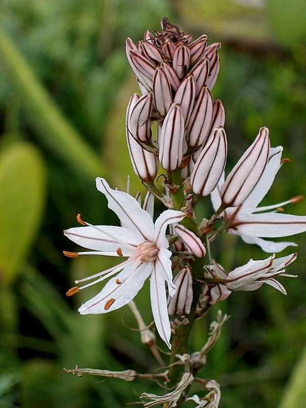 Canarian Asphodel
The mountain belongs to the Monumento Natural de los Volcanes de Teneguía. Therefore behave like in any natural park. The parking lot at the visitor center charges €3.50 per person (even if you don't intend to use it or to visit the centre. When starting from Faro de Fuencaliente be sure to take the western route across Volcán Teneguía. That way you won't pass the ticket booth but after visiting Volcán San Antonio. You can return via the eastern route.
When To Climb
Volcán San Antonio can be climbed all year round. It might be very stormy on the summit so brace yourself: don't carry anything that can be blown away.Accommodation
Camping is a bit of a problem on La Palma. There are some official campgrounds in the north but the one near Los Canarios is still a project. There are, however, a couple of "Zonas Recreativas" where sometimes you are allowed to pitch a tent. None of these are in the vicinity of San Antonio. The best opportunities are the beaches in the south where camping is not allowed but where you'll probably encounter no objections if you go arrive there late enough and start out early.Other accommodations are no problem. Every European travel office will be able to book hotels, rooms and apartments for you. I won't include any links here because all of them definitely are commercial. Another option is to rent a finca (rural house) from the owners directly. You'll have to google for these but sometimes prices are low enough for the scheme to be worthwhile.
Weather Conditions
Usually all year round the Canarias have the same weather with little alterations: north-eastern trade winds which deposit fog and dew on the north-eastern slopes of the islands. The eastern and southern parts usually are very dry and there you'll get some hours of sunshine each day. Especially on the higher islands like La Palma you usually don't have to worry about weather too much. The mountaintops will stick out of the clouds.Now here's the problem: when we were on our vacation to La Palma in late Febuary 2005 we had a week of fierce western winds which were loaded with moisture. We had veritable downpours for ours on end and several times couldn't even drive by car because the roads were flooded. I'm quite sure that this was a freak phenomenon. The western side of La Palma usually gets 28cm (19 inches) of rain per year!
There are no reliable weather forecasts for the mountain regions of La Palma. Often a cloudless day turns into a foggy one within half an hour. Especially the Cumbre Vieja Range is prone to these fogs and here orientation among the lava and scree fields gets very difficult. This is the main reason why you should never leave the trails there.
Forecasts for the coastal regions, however are available. You have to substract 1°C for every 100m of altitude so that Roque de los Muchachos will still be near freezing when the coasts have already fine and sunny beach weather. The following table gives a little overview about the average weather data of the capital of Santa Cruz:
| Month | Jan | Feb | Mar | Apr | May | Jun | Jul | Aug | Sep | Oct | Nov | Dec |
| Avg. day temp.[°C / °F] | 21 / 70 | 21 / 70 | 22 / 72 | 22 / 72 | 22 / 72 | 24 / 75 | 25 / 77 | 26 / 79 | 26 / 79 | 26 / 79 | 24 / 75 | 22 / 72 |
| Avg. night temp.[°C / °F] | 15 / 59 | 14 / 57 | 15 / 59 | 16 / 61 | 17 / 63 | 18 / 64 | 19 / 66 | 21 / 70 | 21 / 70 | 19 / 66 | 18 / 64 | 16 / 61 |
| Water temp.[°C / °F] | 19 / 66 | 18 / 64 | 19 / 66 | 19 / 66 | 19 / 66 | 20 / 68 | 22 / 72 | 23 / 73 | 22 / 72 | 22 / 72 | 21 / 70 | 20 / 68 |
| Sunny Hours / Day | 5 | 6 | 6 | 7 | 8 | 9 | 10 | 9 | 8 | 6 | 5 | 5 |
Maps 'n' Books
Please excuse me if I only post German maps and books. I know there are editions in all European languages but I'm not aware of them. Any help is very welcome!I have used a fantastic map by Freytag & Berndt which shows all of the many hiking and biking trails of the island. With its scale of 1:30000 it is still large enough to be useful for car tours as well. Moreover here you will find all the new designations and acronyms (which were changed some few years back).
- La Palma
1:30000
Edition Freytag & Berndt
ISBN: 3-7079-0346-X
The guidebook I used is every bit as good as the map with excellent tour descriptions. It is available in English as well but I am not sure about the quality of the translation.
- La Palma
A. and W. Wolfsperger
Rother Verlag
ISBN:
3-7633-4246-X (German)
3-7633-4808-5 (English)
External Links
- 360° Summit Panorama Volcán San Antonio
Click on it and move the mouse