
-
 11665 Hits
-
 84.82% Score
-
 19 Votes
|
|
Mountain/Rock |
|---|---|
|
|
28.60460°N / 17.8412°W |
|
|
Hiking |
|
|
Spring, Summer, Fall, Winter |
|
|
5928 ft / 1807 m |
|
|
Overview
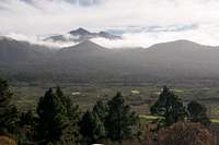
 Cumbre Vieja seen from the ascent to Reventon Pass Cumbre Vieja seen from the ascent to Reventon Pass |
Pico Birigoyo is the northernmost of the main summits on La Palma's Cumbre Vieja Range. It is a perfectly cone-shaped volcano, consisting largely of the tiny lava scree which is so typical of the Canarias. As northernmost outpost of Cumbre Vieja it sees much weather action. The low trade wind clouds usually get pushed up far enough on the eastern slopes of the island that they just reach the Altitudes of the Cumbre Nueva Range to the North of Birigoyo. Due to turbulences around Birigoyo's summit, they often get sucked up towards it.
Consequently a climb of Pico Birigoyo should be started very early. The trade winds get fiercer during the day and additionally any moisture left in the slopes of the mountains will evaporate in the morning sun. Often Birigoyo's summit is shrouded in clouds by noon. Only around sunset - when the winds die down again - you have a second chance for a cloud-free summit.
 |  |  |
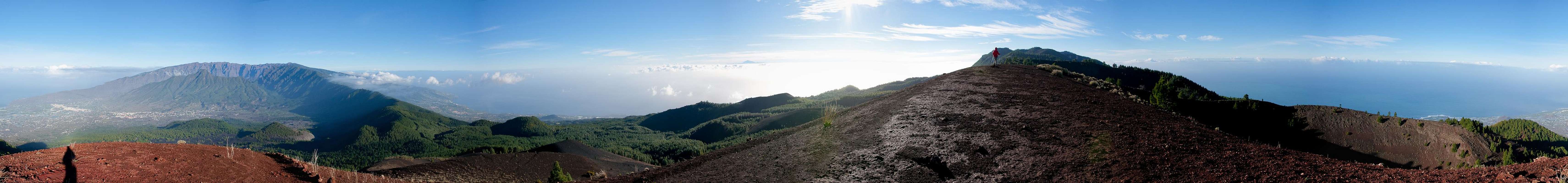
And cloud-free it should be. The exposed position above Cumbre Nueva offers great views towards the Caldera de Taburiente to the north and the Cumbre Vieja volcanoes to the south. On clear days neighbouring La Gomera and even mighty Teide on Tenerife can be seen.
 On the Pico Birigoyo Summit
The Cumbre Vieja range - in contrast to its name - is the youngest part of La Palma. Over the ages volcanism on the island has been relocating towards the south with the latest eruption on the southern tip of the island, which created Volcán Teneguía. The range has been discussed a lot lately, because of a possible huge landslide, which could cause a tsunami of unknown proportions (see below). Pico Birigoyo itself has been dormant for as long as charts about eruptions in the Canarias have been kept. There have been seven historic eruptions, starting from 1470, but Birigoyo was not among them. However, Montaña Quemada at the northern base of Birigoyo as well as Montaña Taduya to its north-west belong to these historic events, having erupted in 1470 and 1585 respectively.
 |  |  |
Birigoyo is a very popular summit. It is located close to the northern trailhead of the Ruta de los Volcanes trekking trail at Rifugio del Pilar and can be reached in 90min from there. Also, there are quite a number of hiking-trails in the west of Birigoyo so that the area to the mountain's base is always full of people.
360° Summit Panorama
  |
Geography of La Palma and the Mega-Tsunami Theory
 La Palma as seen from the ISS from the north-west |
First of all let me state that I will post this section to all La Palma pages which I intend to post here. Both topics, the geography of the island as well as the Mega-Tsunami Theory are far too interesting to be left out. So if you have read it somewhere before, just skip this section.
Geography
La Palma, like said above and like all the other Canarian Islands is of volcanic origin. Actually you can draw a pretty accurate comparison to the Hawaiian Islands since both groups are similar in many respects. The Canarias have been formed 25 - 2 million years ago with La Palma one of the youngest islands together with tiny El Hierro. What strikes us most today is that the ocean floor around and between the islands is about 4000m deep, which makes mighty Teide (3718m) on Tenerife a truly impressive mountain if you consider the elevation from the ocean floor.
La Palma is not quite as impressive but it is the second highest of the Canarias with its highpoint, Roque de los Muchachos at 2426m. On the other hand it is the third smallest of the islands and thus the ratio of overall material to island area is the largest you will find for any island on earth. This makes it the prime candidate for causing the next mega-tsunami (see below).
The Island can be divided in three mountainous regions:
- the Caldera de Taburiente in the north, the world's largest erosion crater with a diameter of 29km and with caldera walls up to 2000m deep! The caldera is the leftover of a huge volcano which used to exist ages ago and which collapsed by sliding to the west of the island 550.000 years ago.
- the Cumbre Nueva, also the leftover of an even larger volcano. If you look at the little map you will see the Cumbre Nueva in the centre of the island. If you take the curvature of the cumbre and prolong it you will see just how large it really was. This volcano also dropped away to the west of the island.
- the Cumbre Vieja. Though viejo means old, this is the youngest part of the island by far. Here you can find 120 volcanoes, all very close to each other on this mountain range, which reaches 1945m in height. It is here that the next landslide to the west of the island is expected which is supposed to cause a devastating mega tsunami.
The Mega Tsunami TheoryClick here for the original scientific paper found by rbi.
To make it short: in 1949, three of the volcanoes (San Juan, Montaña del Fraile and Pico Nambroque) of the Cumbre Vieja erupted simultaneously. Large lava flows covered the western parts of the island and there were a lot of heavy earthquakes. During the eruption a large crack developed and the western part of the Cumbre Vieja slipped by 4m (12ft). Since deep chimneys have been found in the higher regions of the range, which all consist of porous, water-filled rocks, it is expected that the next eruption in this central region of the Cumbre Vieja will be so explosive, that the crack of 1949 widens and eventually the western part of the Cumbre Vieja would tumble into the sea. With huge amounts of material (500 billion tons) rushing to the sea huge waves would be created, which finally will hit the US and the Gulf of Mexico with devastating effects.
Since La Palma and neighbouring El Hierro have a history of these massive landslides a scenario likes this seems feasible. But nobody knows when - or even if - this will happen. Heavy eruptions occur every 200 years on La Palma and it is far from clear that the crack, which developed in 1949 actually is deep enough to split the island in two.
Getting There
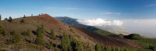 Pico Birigoyo in front of Cumbre Nueva
La Palma, like all the other Canarian Islands can easily be reached from almost all major European airports. The airport is rather small and compared to Tenerife or Gran Canaria air traffic is rather low. There are almost no regular flights but all year round you'll be able to book charter flights.
To reach Rifugio del Pilar head out northward From the airport on LP-1, which you leave at a roundabout, heading in the direction of Los Llanos along LP-2. You cross the Cumbre Nueva through the long Cumbre tunnel and immediately afterwards (the two lane road combines into a single lane) turn onto LP-203 southward. Follow the road up to its (almost) highest point where you'll recognize the rifugio by the number of cars parked to the side of the road.
Red Tape
 Caldera de Taburiente during the ascent to Pico Birigoyo
The Mountain is part of the Parque Natural de Cumbre Vieja. Inside park limits you are not allowed to leave trails nor to camp. Near Rifugio del Pilar, however there are two camping zones. I suppose that you have to make reservations (at the Rifugio or at the Centro de Visitantes de Parque Nacional de la Caldera de Taburiente east of El Paso).
When To Climb
The mountain can be climbed all year round. Only fog has to be considered. The fog can be very dense, the slopes (especially in the north) are very steep so take your time.Camping
There are two camping zones near rifugio del Pilar near Montaña de la Venta. For reservations ask at the Rifugio.Other accommodations are no problem. Every European travel office will be able to book hotels, rooms and apartments for you. I won't include any links here because all of them definitely are commercial. Another option is to rent a finca (rural house) from the owners directly. You'll have to google for these but sometimes prices are low enough for the scheme to be worthwhile.
Mountain Conditions
Usually all year round the Canarias have the same weather with little alterations: north-eastern trade winds which deposit fog and dew on the north-eastern slopes of the islands. The western and southern parts usually are very dry and there you'll get some hours of sunshine each day. Especially on the higher islands like La Palma you usually don't have to worry about weather too much. The mountaintops will stick out of the clouds.
There are no reliable weather forecasts for the mountain regions of La Palma. Often a cloudless day turns into a foggy one within half an hour. Especially the Cumbre Vieja Range is prone to these fogs and here orientation among the lava and scree fields gets very difficult. This is the main reason why you should never leave the trails there.
Forecasts for the coastal regions, however are available. You have to subtract 1°C for every 100m of altitude so that Roque de los Muchachos will still be near freezing when the coasts have already fine and sunny beach weather. The following table gives a little overview about the average weather data of the capital of Santa Cruz:
| Month | Jan | Feb | Mar | Apr | May | Jun | Jul | Aug | Sep | Oct | Nov | Dec |
| Avg. day temp.[°C / °F] | 21 / 70 | 21 / 70 | 22 / 72 | 22 / 72 | 22 / 72 | 24 / 75 | 25 / 77 | 26 / 79 | 26 / 79 | 26 / 79 | 24 / 75 | 22 / 72 |
| Avg. night temp.[°C / °F] | 15 / 59 | 14 / 57 | 15 / 59 | 16 / 61 | 17 / 63 | 18 / 64 | 19 / 66 | 21 / 70 | 21 / 70 | 19 / 66 | 18 / 64 | 16 / 61 |
| Water temp.[°C / °F] | 19 / 66 | 18 / 64 | 19 / 66 | 19 / 66 | 19 / 66 | 20 / 68 | 22 / 72 | 23 / 73 | 22 / 72 | 22 / 72 | 21 / 70 | 20 / 68 |
| Sunny Hours / Day | 5 | 6 | 6 | 7 | 8 | 9 | 10 | 9 | 8 | 6 | 5 | 5 |
Maps & Books
Please excuse me if I only post German maps and books. I know there are editions in all European languages but I'm not aware of them. Any help is very welcome!I have used a fantastic map by Freytag & Berndt which shows all of the many hiking and biking trails of the island. With its scale of 1:30000 it is still large enough to be useful for car tours as well. Moreover here you will find all the new designations and acronyms (which were changed some few years back).
- La Palma
1:30000
Edition Freytag & Berndt
ISBN: 3-7079-0346-X
The guidebook I used is every bit as good as the map with excellent tour descriptions. It is available in English as well but I am not sure about the quality of the translation.
- La Palma
A. and W. Wolfsperger
Rother Verlag
ISBN:
3-7633-4246-X (German)
3-7633-4808-5 (English)