
-
 6811 Hits
-
 80.49% Score
-
 12 Votes
|
|
Mountain/Rock |
|---|---|
|
|
28.55927°N / 17.84141°W |
|
|
Hiking |
|
|
Spring, Summer, Fall, Winter |
|
|
5853 ft / 1784 m |
|
|
Overview
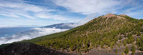
 Montaña Negra during the approach from Ruta de los Volcanes Montaña Negra during the approach from Ruta de los Volcanes |
Montaña Negra, the black mountain - there are few mountains which deserve this name more than a big cratered volcano on the main ridge of Cumbre Vieja, the youngest mountain range of La Palma or indeed of the whole Canary Islands Archipelago. La Palma has been named Isla Verde, the Green Island, but here recent (in geological terms) volcanic activity has left a veritable desert. At almost 2000m (6000ft).
 |  |  |
There are no historic records for an eruption of Montaña Negra so that you can date it back to mediaeval times or earlier. But when it erupted, it must have been one of the largest eruptions that ever happened in the mountain range since it tore one of the largest and deepest craters into the ground, which can be found on the island. Hoyo Negro is bigger, Duraznero is more colourful but given its old age, the Montaña Negra's caldera still impresses with its shape and colour.
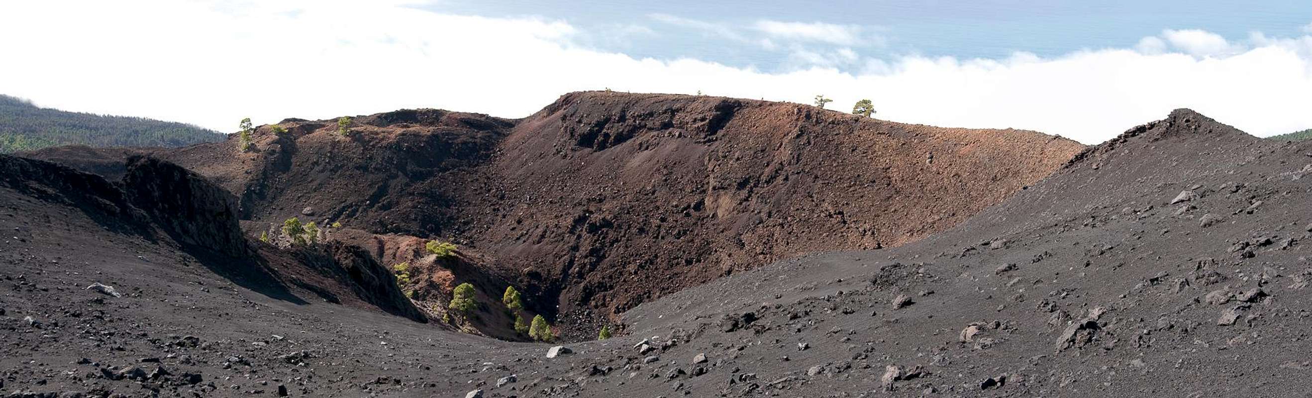  |
It emitted a huge amount of black cinder, which piled up on its eastern side, covering a huge area with black sands. Even today, more than 500 years after the eruption anly few plants grow here, most of them pioneering Canary Pines. Montaña Negra also created one of the longest lava flows of the island, a flow which was directed westward and which almost reached the western shore near the place where today you find the tourist resort of El Remo. The flow also consisted of relatively small particles which gave rise to its name: Los Sablos.
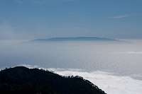
Montaña Negra is located several hundred metres to the west of the Cumbre Vieja main ridge, to the south-west of its highpoint, Volcan de la Deseada. Summit views are not perfect as the higher ridge of the range obstructs much of the views. However, the island of El Hierro can be seen in the south while Caldera de Taburiente peeps out behind Volcan de la Deseada. Thus, Montaña Negra is rather a destination for peak-baggers and students of volcanism than a tourist hot spot.
360° Summit Panorama
 |
Getting There
 Volcán Cabrito, Montaña de los Berejales, Montaña Negra
La Palma, like all the other Canary Islands can easily be reached from almost all major European airports. The airport is rather small and compared to Tenerife or Gran Canaria air traffic is rather low. There are almost no regular flights but all year round you'll be able to book charter flights.
There are three reasonable trailheads, one at Rifugio del Pilar in the north, one at Fuencaliente in the south and one at Jedey in the east. The latter two trailheads require an elevation gain of 1600m and 1300m respectively and thus are far less popular. The elevation gain from the rifugio in the north can amount to 1200m if you follow the main ridge of Cumbre Nueva and about 900m when you follow the Ruta de los Volcanes.
To reach Rifugio del Pilar head out northward From the airport on LP-1, which you leave at a roundabout, heading in the direction of Los Llanos along LP-2. You cross the Cumbre Nueva through the long Cumbre tunnel and immediately afterwards (the two lane road combines into a single lane) turn onto LP-203 southward. Follow the road up to its (almost) highest point where you'll recognize the rifugio by the number of cars parked to the side of the road.
Red Tape
 Caldera de Taburiente and Volcan de la Deseada
The Mountain is part of the Parque Natural de Cumbre Vieja. Inside park limits you are not allowed to leave trails nor to camp. Near Rifugio del Pilar, however there are two camping zones. You have to make reservations (at the Rifugio or at the Centro de Visitantes de Parque Nacional de la Caldera de Taburiente east of El Paso).
Accommodation
There are two camping zones near rifugio del Pilar near Montaña de la Venta. For reservations ask at the Rifugio.Other accommodation is easy to find. Every European travel office will be able to book hotels, rooms and apartments for you. I won't include any links here because all of them definitely are commercial. Another option is to rent a finca (rural house) from the owners directly. You'll have to google for these but sometimes prices are low enough for the scheme to be worthwhile.
Weather Conditions
Usually all year round the Canarias have the same weather with little alterations: north-eastern trade winds which deposit fog and dew on the north-eastern slopes of the islands. The western and southern parts usually are very dry and there you'll get some hours of sunshine each day. Especially on the higher islands like La Palma you usually don't have to worry about weather too much. The mountaintops will stick out of the clouds.
There are no reliable weather forecasts for the mountain regions of La Palma. Often a cloudless day turns into a foggy one within half an hour. Especially the Cumbre Vieja Range is prone to these fogs and here orientation among the lava and scree fields gets very difficult. This is the main reason why you should never leave the trails there.
Forecasts for the coastal regions, however are available. You have to subtract 1°C for every 100m of altitude so that Roque de los Muchachos will still be near freezing when the coasts have already fine and sunny beach weather. The following table gives a little overview about the average weather data of the capital of Santa Cruz:
| Month | Jan | Feb | Mar | Apr | May | Jun | Jul | Aug | Sep | Oct | Nov | Dec |
| Avg. day temp.[°C / °F] | 21 / 70 | 21 / 70 | 22 / 72 | 22 / 72 | 22 / 72 | 24 / 75 | 25 / 77 | 26 / 79 | 26 / 79 | 26 / 79 | 24 / 75 | 22 / 72 |
| Avg. night temp.[°C / °F] | 15 / 59 | 14 / 57 | 15 / 59 | 16 / 61 | 17 / 63 | 18 / 64 | 19 / 66 | 21 / 70 | 21 / 70 | 19 / 66 | 18 / 64 | 16 / 61 |
| Water temp.[°C / °F] | 19 / 66 | 18 / 64 | 19 / 66 | 19 / 66 | 19 / 66 | 20 / 68 | 22 / 72 | 23 / 73 | 22 / 72 | 22 / 72 | 21 / 70 | 20 / 68 |
| Sunny Hours / Day | 5 | 6 | 6 | 7 | 8 | 9 | 10 | 9 | 8 | 6 | 5 | 5 |
Maps & Books
Maps
I have used a fantastic map by Freytag & Berndt which shows all of the many hiking and biking trails of the island. With its scale of 1:30000 it is still large enough to be useful for car tours as well. Moreover here you will find all the new designations and acronyms (which were changed some few years back).
- La Palma
1:30000
Edition Freytag & Berndt
ISBN: 3-7079-0346-X
Books
The guidebook I used is every bit as good as the map with excellent tour descriptions. It is available in English as well but I am not sure about the quality of the translation.
- La Palma
A. and W. Wolfsperger
Rother Verlag
ISBN:
3-7633-4246-X (German)
3-7633-4808-5 (English)