
-
 16412 Hits
-
 91.45% Score
-
 35 Votes
|
|
Mountain/Rock |
|---|---|
|
|
28.53820°N / 17.8387°W |
|
|
Hiking |
|
|
Spring, Summer, Fall, Winter |
|
|
5240 ft / 1597 m |
|
|
Overview
 Summit View Montaña del Fuego towards Volcán Martín (1597m) Summit View Montaña del Fuego towards Volcán Martín (1597m) |
Volcán Martín will always stand out as one of the (emotional) highpoints of my stay on the beautiful Island of La Palma in the Islas Canarias. I hope that some of the pictures I'm posting here will explain why: the crater and both summits are painted in colours that otherwise only expressionist painters would use. Of course it helped that we climbed Volcán Martín on the single perfect day of our vacation. Maybe here also pictures tell more than words can relate.
The volcano is one among the 120 odd volcanoes and craters which can be found in the Cumbre Vieja Range of La Palma. This Range in turn is the most active volcanic zone of La Palma and - come to think of it - of the whole Canarias. All seven eruptions which have been recorded in historical times have taken place here. Volcán Martín itself broke out in 1646 and thus is among the latest five known eruptions.
 |  |  |
While the lower slopes of the volcano are covered with the fine black lava scree, which is so typical of the Canarias, the upper part with the crater and both summits is composed of red sintered material. The crater contains a source, the Fuente del Fuego, located in a volcanic cave. Don't expect too much from this source; most of the time it is dripping only. After heavy rains - and we witnessed those in Febuary - the Fuente actually holds a little pool. Very strange to behold in this otherwise almost barren landscape.
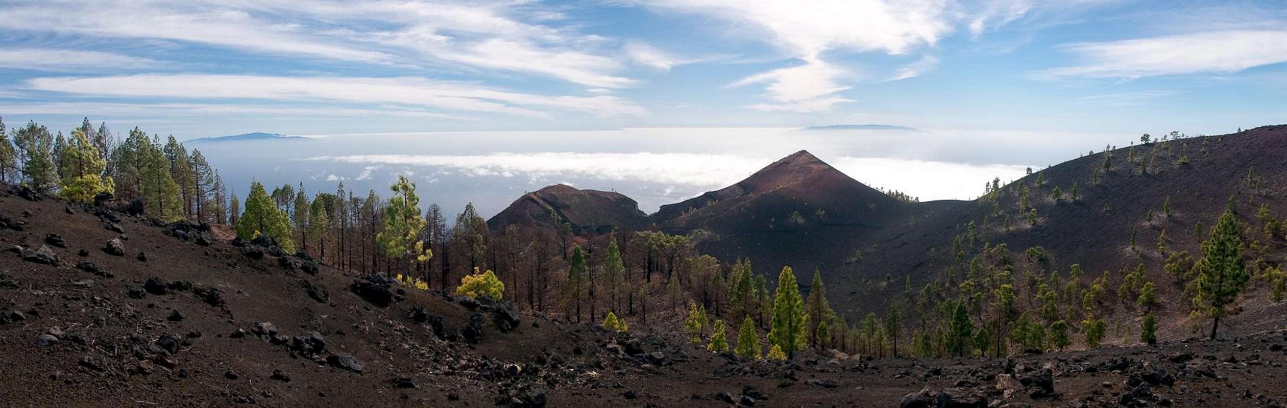
Speaking of which I should add that the slopes of all the Cumbre Vieja are covered by those most beautiful of Pines: the long (and soft) needled Canarian Pines. These forests would be worth a visit even if there were no mountains to top them with.
 |  |  |
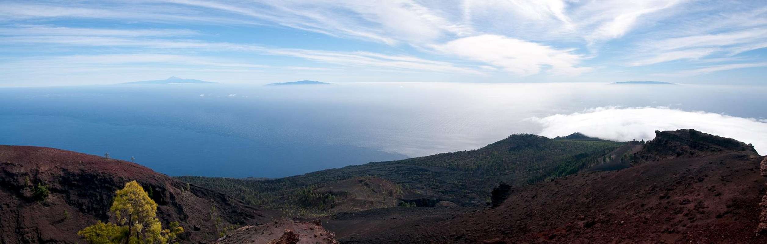
Volcán Martín is located centrally on the Cumbre Vieja Ridge. It is - seen from the southern tip of the island - the first major summit. From here the Cumbre Vieja rapidly rises as you hike northwards to reach almost 2000m in Deseada I. Due to this fact Volcán Martín is - presuming fine weather - a perfect lookout peak. Not only can you see the neighbouring volcanoes of the Cumbre Vieja, but also the islands of La Gomera, El Hierro and Tenerife with the ever imposing Teide. We were very lucky to see Teide completely covered in snow (runner-up in the Mount Hood look-alike contest), a sight very very rare. All of the Cañadas del Teide, Pico Viejo and Guajara were covered with the white stuff.
View from or of the summit
  |
Geography of La Palma and the Mega-Tsunami Theory
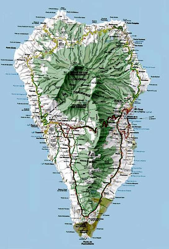 First of all let me state that I will post this section to all Cumbre Vieja pages which I intend to post here. Both topics, the geography of the island as well as the Mega-Tsunami Theory are far too interesting to be left out. So if you have read it somewhere before, just skip this section. Geography La Palma, like said above and like all the other Canarian Islands is of volcanic origin. Actually you can draw a pretty accurate comparison to the Hawaiian Islands since both groups are similar in many respects. The Canarias have been formed 25 - 2 million years ago with La Palma one of the youngest islends together with tiny El Hierro. What strikes us most today is that the ocean floor around and between the islands is about 4000m deep, which makes mighty Teide (3718m) on Tenerife a truly impressive mountain if you consider the elevation from the ocean floor. La Palma is not quite as impressive but it is the second highest of the Canarias with its highpoint, Roque de los Muchachos at 2426m. On the other hand it is the third smallest of the islands and thus the ratio of overall material to island area is the largest you will find for any island on earth. This makes it the prime candidate for causing the next mega-tsunami (see below). The Island can be divided in three mountainous regions:
The Mega Tsunami Theory Click here for the original scientific paper found by Rick B. To make it short: in 1949, three of the volcanoes of the Cumbre Vieja erupted simultaneously. Large lava flows covered the western parts of the island and there were a lot of heavy earthquakes. During the eruption a large crack developped and the western part of the Cumbre Vieja slipped by 4m (12ft). Since deep chimneys have been found in the higher regions of the range, which all consist of porous, water-filled rocks, it is expected that the next eruption in this central region of the Cumbre Vieja will be so explosive, that the crack of 1949 widens and eventually the western part of the Cumbre Vieja would tumbe into the sea. With huge amounts of material rushing to the sea huge waves would be created, which finally will hit the US and the Gulf of Mexico with devastating effects. Since La Palma and neighbouring El Hierro have a history of these massive landslides a scenario likes this seems feasible. But nobody knows when - or even if - this will happen. Heavy eruptions occur every 200 years on La Palma and it is far from clear that the crack, which develpped in 1949 actually is deep enough to split the island in two. |
Getting There
 |
La Palma, like all the other Canarian Islands can easily be reached from almost all major European airports. The airport is rather small and compared to Tenerife or Gran Canaria air trafic is rather low. There are almost no regular flights but all year round you'll be able to book charter flights.
There are two possible trailheads for Volcán Martín: the Zona Recreativa Fuente de los Roques and the town of Los Canarios (La Palma's southernmost one). Both are rather close to each other.
- Fuente de los Roques
From the airport head out south on LP-1322, which soon turns west in the direction of Monte. You soon meet LP-132, on which you turn in southward direction. Near the village of Tigalate LP-132 meets with LP-1 which you drive onto, again in turning south. You'll have to drive through Monte di Luna (also a possible, though faraway trailhead) until you reach km 25.5. Here turn west onto a forest road which runs up through the pine forests to Fuente de los Roques. There are signs at each turn, the Zona Recreativa can't be missed.
- Los Canarios
Same itinerary until Monte de Luna. Here stay on LP-1 and you'll reach Los Canarios. The road turns west within the town limits and you can start your hike near the town church. Look for the signs GR-131 / Ruta de los Volcanes.
Red Tape
 Canarian Pines on the lower sections of the ascent trail
Volcán Martín is part of the Parque Natural de Cumbre Vieja. Within park Limits you are not supposed to leave the trails. Also camping is not allowed, only near the Zonas Recreativas. So, the trailhead at Fuente de Los Roques can be used for overnight accommodation. Water, Picknick benches and tables.
When To Climb
The mountain can be climbed ll year round. In winter you can encounter fierce winds and fog. In these conditions it is not advisable to scramble to the summit. Honestly, it can get real dangerous (orientation and winds).Accommodation
As said above camping is allowed only near the Zonas Recreativas. There are official campgrounds on La Palma but all are located in the north of the island, none near Los Canarios in the south (though one is projected).Other accommodations are no problem. Every European travel office will be able to book hotels, rooms and apartments for you. I won't include any links here because all of them definitely are commercial. Another option is to rent a finca (rural house) from the owners directly. You'll have to google for these but sometimes prices are low enough for the scheme to be worthwhile.
Weather Conditions
Weather on the Canarias is always a little hard to predict. Though usually you can count on north-eastern trade winds you never can say how high the clouds (and there will be clouds!) will reach. Most of the time they'll refrain from covering the south but you cannot be sure. Check the weather when you set out. It will be stable for most of the days.During our vacation to La Palma in late Febuary 2005, however we had a week of fierce western winds which were loaded with moisture. We had veritable downpours for hours on end and several times couldn't even drive by car because the roads were flooded. I'm quite sure that this was a freak phenomenon. The western side of La Palma usually gets 28cm (19 inches) of rain per year! For Cumbre Vieja that meant a cloud cover all the time but for the one day on which we climbed Volcán Martín (among others). On that day the winds died down and couldn't push the clouds across the ridge. "Died down" still means that on the summit of Martín we had to search for cover in order not to be blown away
There are no reliable weather forecasts for the mountain regions of La Palma. Often a cloudless day turns into a foggy one within half an hour. Especially the Cumbre Vieja Range is prone to these fogs and here orientation among the lava and scree fields gets very difficult. This is the main reason why you should never leave the trails there.
Forecasts for the coastal regions, however are available. You have to substract 1°C for every 100m of altitude so that Roque de los Muchachos will still be near freezing when the coasts have already fine and sunny beach weather. The following table gives a little overview about the average weather data of the capital of Santa Cruz:
| Month | Jan | Feb | Mar | Apr | May | Jun | Jul | Aug | Sep | Oct | Nov | Dec |
| Avg. day temp.[°C / °F] | 21 / 70 | 21 / 70 | 22 / 72 | 22 / 72 | 22 / 72 | 24 / 75 | 25 / 77 | 26 / 79 | 26 / 79 | 26 / 79 | 24 / 75 | 22 / 72 |
| Avg. night temp.[°C / °F] | 15 / 59 | 14 / 57 | 15 / 59 | 16 / 61 | 17 / 63 | 18 / 64 | 19 / 66 | 21 / 70 | 21 / 70 | 19 / 66 | 18 / 64 | 16 / 61 |
| Water temp.[°C / °F] | 19 / 66 | 18 / 64 | 19 / 66 | 19 / 66 | 19 / 66 | 20 / 68 | 22 / 72 | 23 / 73 | 22 / 72 | 22 / 72 | 21 / 70 | 20 / 68 |
| Sunny Hours / Day | 5 | 6 | 6 | 7 | 8 | 9 | 10 | 9 | 8 | 6 | 5 | 5 |
Maps 'n' Books
Please excuse me if I only post German maps and books. I know there are editions in all European languages but I'm not aware of them. Any help is very welcome!I have used a fantastic map by Freytag & Berndt which shows all of the many hiking and biking trails of the island. With its scale of 1:30000 it is still large enough to be usefu for car tours as well. Moreover here you will find all the new designations and acronyms (which were changed some few years back).
- La Palma
1:30000
Edition Freytag & Berndt
ISBN: 3-7079-0346-X
The guidebook I used is every bit as good as the map with excellent tour descriptions. It is available in English as well but I am not sure about the quality of the translation.
- La Palma
A. and W. Wolfsperger
Rother Verlag
ISBN:
3-7633-4246-X (German)
3-7633-4808-5 (English)